According to the latest storm information from the Joint Typhoon Warning Center (JTWC), Typhoon Ragasa is currently about 872 km northeast of Manila (Philippines), moving northwest at a speed of about 11 km/h.
Waves around the storm area are up to 8.2 m high.
Over the next 48 hours, Ragasa is forecast to continue to rapidly strengthen thanks to favorable atmospheric conditions and high sea temperatures, which could reach maximum winds of up to 250 km/h and become a super typhoon.
The Philippine Atmospheric, Geophysical and Astronomical Services Administration ( pagasa) said that at 11pm on September 20 (local time), Typhoon Ragasa (local name: Nando) was 710 km east of Isabela and 695 km from Tuguegarao (Cagayan).
The storm has the strongest winds near the center reaching 155 km/h, gusting up to 190 km/h, moving northwest.
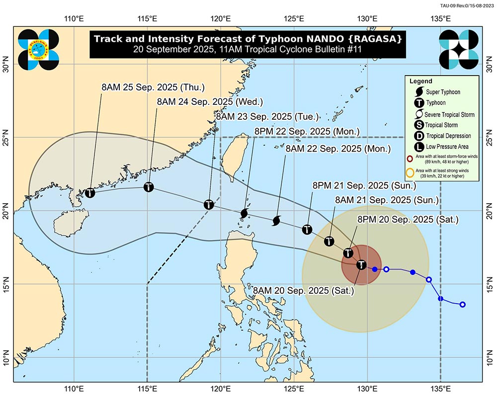
Pagasa forecasts that Ragasa could strengthen into a super typhoon on September 21 (Sunday), approaching the northernmost Luzon and is likely to directly affect or make landfall in Batanes and Babuyan Islands in the afternoon or evening of September 22 (Monday).
The storm is likely to leave the Philippine area of responsibility on the morning of September 23 (Tuesday), moving towards Hong Kong, Macao, southern China and may affect Northern Vietnam when it enters the Gulf of Tonkin.
When it enters the East Sea, Ragasa will become the ninth storm in the East Sea this year. Ragasa is also the strongest super typhoon of 2025.
According to the storm forecast of the National Center for Hydro-Meteorological Forecasting, on the evening of September 20, the strongest wind near the center of Typhoon Ragasa reached level 13 (134-149 km/h), gusting to level 16.
It is forecasted that by 7:00 p.m. on September 21, Typhoon Ragasa will move west-northwest at a speed of 15 km/h, intensifying, reaching level 14-15, gusting above level 17, about 340 km east of Luzon Island.
At 7:00 p.m. on September 22, the storm continued to move west-northwest at 15-20 km/h, strengthening to level 16, gusting above level 17, in the sea north of Luzon Island.
From the afternoon of September 22, the Northeast of the East Sea will have strong winds of level 6-7, then increase to level 8-9, gusting to level 11.
From the night of September 22, the wind will gradually increase to level 10-13; the area near the storm's center may reach level 14-16, gusting above level 17. Waves are 4-8 m high, near the center of the storm alone over 10 m. The sea is rough.
Risk: ships operating in the danger zone will be affected by thunderstorms, whirlwinds, strong winds and large waves.
At 7:00 p.m. on September 23, the storm moved west-northwest at 20-25 km/h, entering the East Sea, about 270 km southeast of Hong Kong (China), maintaining winds of level 16, gusting above level 17.
Dangerous sea area: North of latitude 17.5°N, East of longitude 114.0°E. Natural disaster risk level: level 4 (the northeastern sea area of the East Sea).
The storm is then forecast to move west-northwest, then change direction to west-southwest at a speed of about 20 km/h and gradually weaken.
Due to the impact of super typhoon Ragasa in the East Sea, tourists should limit travel by sea or air in areas directly affected.
Prepare a schedule adjustment plan if you plan to visit the Northern Philippines, Hong Kong, the South in China or the Northern provinces of Vietnam in the next few days.


