According to the latest storm information from the Philippine Atmospheric, Geophysical and Astronomical Services Administration (PAGASA), Typhoon Ragasa (Philippine name Nando) continued to strengthen this morning, September 20, as it moved closer to the Philippine mainland.
At around noon on Saturday, the center of the storm was about 775 km east of Casiguran (Aurora). This is a potential storm No. 9 entering the East Sea next week right after Typhoon No. 8 weakened in mainland China.
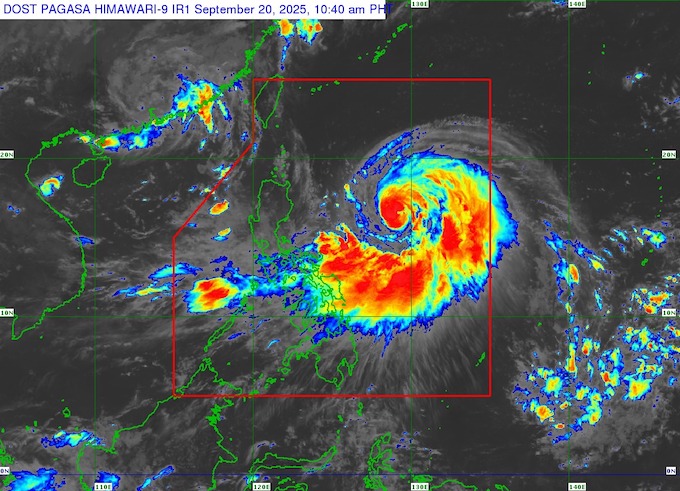
It is forecasted that in the next 24 hours, Typhoon Ragasa will move northwest, then gradually turn west-northwest, towards the northernmost tip of Luzon Island.
The center of the storm is likely to approach or make landfall directly in the Batanes or Babuyan Islands of the Philippines between the evening of September 22 (Monday) and the early morning of September 23 (Tuesday).
The storm could then leave the Philippine Area of Responsibility (PAR) at noon or afternoon on Tuesday, September 23, and enter the South China Sea as the ninth typhoon.
PAGASA warned that Ragasa will continue to strengthen, possibly reaching super typhoon level on September 22 (Monday), right before approaching Babuyan.
Waves around the Luzon coast are expected to rise 3 to 14m from September 21 (Sunday). The risk of storm surge may appear in the northern coast of Luzon.
Currently, Typhoon Ragasa has not directly affected the weather at sea in our country.
The National Center for Hydro-Meteorological Forecasting predicts that by the morning of September 21, Typhoon Ragasa is likely to strengthen to level 13, gusting to level 16, about 530km east of Luzon Island.
By the morning of September 22, the storm continued to strengthen to level 15, gusting above level 17, about 240km northeast of Luzon.
On the morning of September 23, the storm moved faster (20-25km/h), likely entering the East Sea, maintaining a very strong intensity of level 15-16, gusting above level 17.
The danger zone is identified as being 17.0 degrees North latitude North of the North latitude and 116.5 degrees East longitude East of the East longitude. The North East Sea area is warned of level 3 natural disaster risk.
After entering the East Sea, storm No. 9 Ragasa is likely to continue moving west-northwest at a speed of about 20km/h, but its intensity will gradually weaken as it moves further inland.
From the afternoon of September 22, the eastern sea area of the North East Sea will start to have strong winds of level 6-7, then increase to level 8-9, gusting to level 11. From the night of September 22, the wind will gradually increase to level 10-13, the area near the storm's eye will reach level 14-16, gusting above level 17.
Waves are 4-8m high, near the center of the storm alone, they can exceed 10m, the sea is very rough. Ship operating in this area are at high risk of thunderstorms, tornadoes, strong winds and dangerous large waves.
People and tourists should closely monitor weather forecast information from local meteorological agencies, limit going out during the storm. Avoid traveling to coastal areas where there is a risk of high waves and high tides.
If staying at a hotel or resort, you should follow staff's safety instructions and prepare essential items such as drinking water, spare batteries and basic medicine.
In addition, tourists planning to travel by air or rail should check the status of flights and trains in advance because their schedules may be affected by bad weather.


