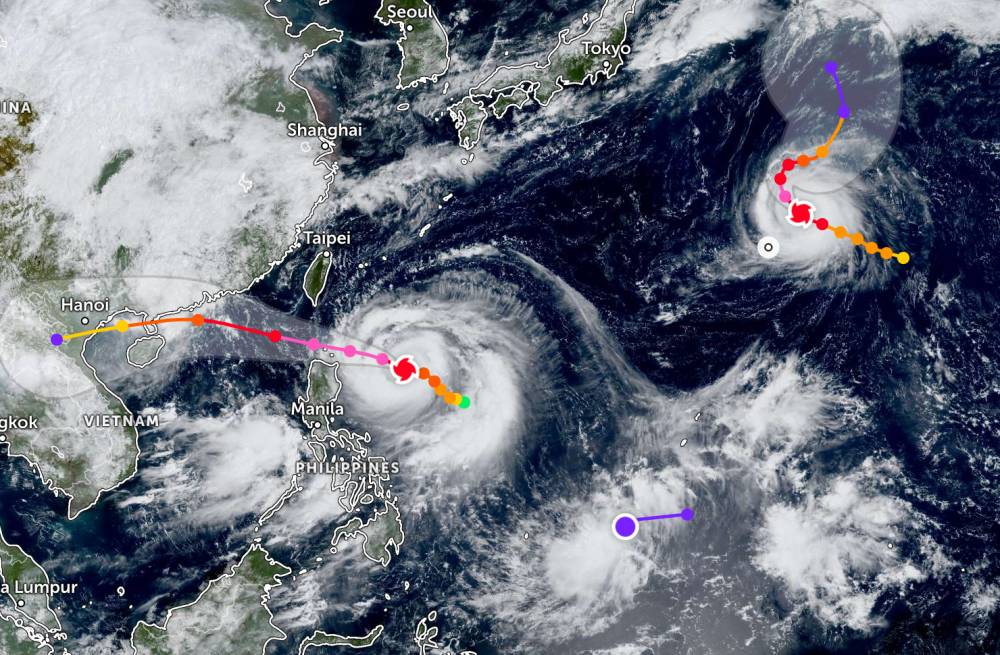
According to storm information from the Philippine Atmospheric, Geophysical and Astronomical Services Administration, on the morning of September 21, Neoguri strengthened into a super typhoon.
As of 2:00 a.m. (local time), the center of the storm was at about 26.8 degrees North latitude - 153.7 degrees East longitude, about 3,305 km northeast of the northernmost tip of Luzon. The storm is moving west-northwest at a speed of about 25 km/h, towards Yokosuka (Japan).
The strongest wind near the center of the super typhoon reached 185 km/h, gusting up to 230 km/h.
According to the Joint Typhoon Warning Center (JWTC), super typhoon Neoguri is Japan's 19th typhoon, currently about 1,639 km east-southeast of Yokosuka (Japan). In the past 6 hours, the super typhoon has been moving west-northwest at a speed of 22 km/h. The maximum waves were recorded at 9.8 meters.
The storm is active at sea, quite far from the mainland, so it has not yet affected Japan.
It is forecasted that in the next 36 hours, the storm will move along the ring road, likely to continue to strengthen.
The name Neoguri was given to Japan's 8th typhoon in 2014, reaching super typhoon level strength. The Japan Meteorological Agency assessed Neoguri as the strongest super typhoon in decades to hit the country. The strong winds of 240km/h and its large circulation have caused record-breaking rainfall in many areas across Japan and South Korea.
Meanwhile, super typhoon RAGASA is currently active in the Philippine Area of Responsibility. As of 8:00 a.m. on September 21, the center of the storm was at about 17.9 degrees North latitude - 127.0 degrees East longitude, about 555 km east of Tuguegarao, Cagayan.
The super typhoon is moving west at a speed of 15 km/h. The strongest wind near the center of the storm reached 185 km/h, gusting up to 230 km/h.
Due to the impact of the storm, Metro Manila, Central Luzon, CALABARZON, Bicol Region, MIMAROPA, Visayas, Northern Mindanao, Zamboanga Peninsula, Caraga, Davao Occidental and Davao Oriental will have heavy rain and strong gusts of wind.
At sea, from September 22, the northeastern area of the East Sea will have winds gradually increasing to level 8-9, then increasing to level 10-14; The area near the storm's eye will have strong winds of level 15-17, gusting above level 17. Waves are over 10 m high, the sea is rough.
People and tourists planning to visit these sea areas or areas where super typhoons swept through should pay attention to weather forecasts. Check your flight schedule and follow local instructions.


