Three typhoons, the strongest super typhoon forecast in 2025 is about to enter the East Sea

Ninh Phương |

The current hurricane season has up to three storms in the Pacific Ocean. Of which, the strongest super typhoon of 2025 will enter the East Sea right after storm No. 8.

According to the latest storm information from the Taiwan Meteorological Station (China), on September 19, three tropical depressions in the Northwest Pacific Ocean strengthened into tropical storms, named Mitag (storm No. 8 in Vietnam), Ragasa (likely to enter the East Sea as storm No. 9) and Neoguri.

Of which, Typhoon No. 8 Mitag made landfall in Guangdong (China) on the afternoon of September 19 and is rapidly weakening.

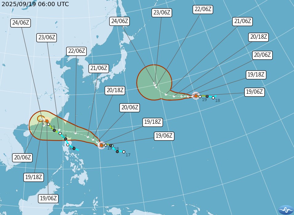
Typhoon Ragasa is located about 1,230 km southeast of Eluanbi Cape (the southernmost point of Taiwan, China), with maximum sustained winds of 72 km/h, gusting to 101 km/h.

Typhoon Ragasa is moving west-northwest towards the Bashi Strait, likely to strengthen into a super typhoon as it enters the East Sea in the next few days.

Ragasa is forecast to be the ninth storm in the South China Sea in the 2025 typhoon season. Maximum winds near the center of the storm could reach 220km/h as it approaches Luzon, Philippines.

Typhoon Neoguri is currently active off the southeastern coast of Japan, away from East Asia, so it has not yet had a direct impact on land.

Du bao duong di va vung anh huong cua bao Ragasa (trai) cung bao Neoguri khi bao so 8 Mitag suy yeu. Hai con bao deu dang tang toc manh len cap cuong phong. Anh: CWA
Forecast of the path and affected areas of Ragasa (left) and Neoguri as Typhoon No. 8 Mitag weakens. Both storms are accelerating to typhoon level. Photo: CWA

Meanwhile, the Korea Meteorological Agency (KMA) said the three storms will bring widespread rain over the weekend of 19-21.

The consensus forecast model predicts that Ragasa is warned to become one of the strongest storms of 2025, with the area of influence stretching from the northern Philippines, southern Taiwan to the coast of Guangdong - Hong Kong (China).

Tourists planning to visit Taiwan (China) on September 22-25 should closely monitor information about Typhoon Ragasa.

The time from Tuesday, September 23 to Wednesday morning, September 24 is forecast to be the time of the strongest storm and can cause very heavy rain and thunderstorms in the east and southeast of the island. Some routes and ships are likely to be interrupted.

Tourists to Hong Kong and Guangdong (China) should note that Typhoon Mitag has weakened after making landfall but still has showers and gusts in the short term.

If you plan to travel during this period, you should check flight status, limit sea travel, prepare safe shelter measures, and update recommendations from local meteorological agencies.

Ninh Phương
TIN LIÊN QUAN

Super typhoon Ragasa appears today, with destructive winds of 250km/h entering the East Sea

|

Typhoon Ragasa rapidly strengthened into a super typhoon today, with destructive power as it approached the East Sea right after Typhoon No. 8 Mitag.

Storm Ragasa rapidly intensifies into a super typhoon in the East Sea in the next 3 days

|

Storm Ragasa continuously increased in intensity, with winds from 65km/h soaring to 120km/h, gusting to 155km/h in just 3 days. Ragasa is forecast to become the ninth typhoon in the South China Sea, reaching super typhoon status.

Storm No. 9 quickly connects storm No. 8 to the East Sea, forecast to become a super typhoon

|

According to the latest storm news, the tropical depression near the East Sea has strengthened into a storm. The storm is forecast to enter the East Sea right after storm No. 8.

Bão cuồng phong RAGASA thành siêu bão trước khi vào Biển Đông 24 giờ tới

Chí Long |

Dự báo bão cuồng phong RAGASA sẽ mạnh lên cấp siêu bão trong 24 giờ tới.

Super typhoon Ragasa appears today, with destructive winds of 250km/h entering the East Sea

Ninh Phương |

Typhoon Ragasa rapidly strengthened into a super typhoon today, with destructive power as it approached the East Sea right after Typhoon No. 8 Mitag.

Storm Ragasa rapidly intensifies into a super typhoon in the East Sea in the next 3 days

Ninh Phương |

Storm Ragasa continuously increased in intensity, with winds from 65km/h soaring to 120km/h, gusting to 155km/h in just 3 days. Ragasa is forecast to become the ninth typhoon in the South China Sea, reaching super typhoon status.

Storm No. 9 quickly connects storm No. 8 to the East Sea, forecast to become a super typhoon

Ninh Phương |

According to the latest storm news, the tropical depression near the East Sea has strengthened into a storm. The storm is forecast to enter the East Sea right after storm No. 8.