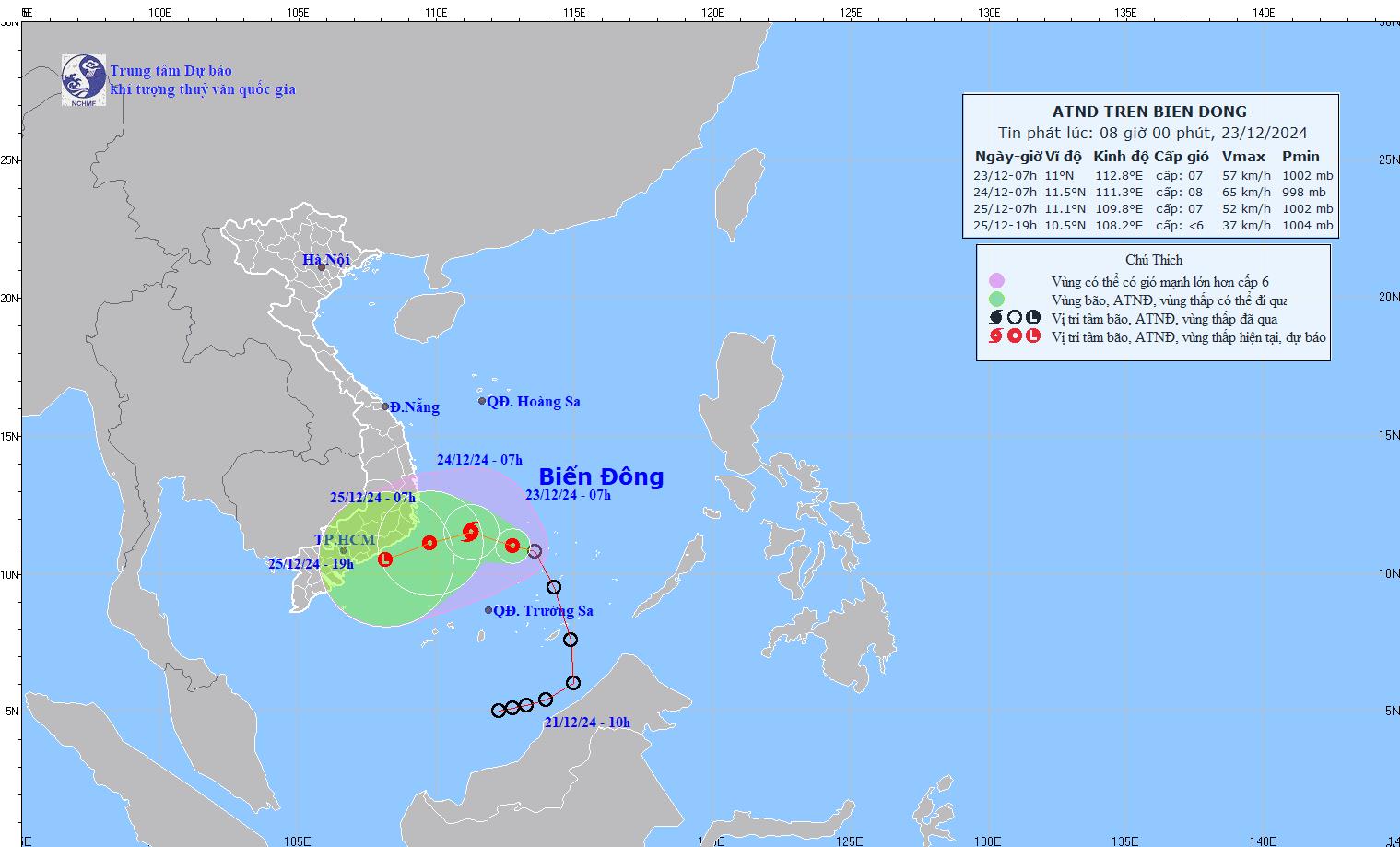
According to the latest weather forecast from the National Center for Hydro-Meteorological Forecasting, at 7:00 a.m. on December 23, the center of the tropical depression was located at about 11.0 degrees North latitude - 112.8 degrees East longitude, in the area northwest of Truong Sa archipelago.
The strongest wind near the center of the tropical depression is level 7 (50-61km/h), gusting to level 9. The tropical depression moves in the West Northwest direction, at a speed of 10km/h.

It is forecasted that by 7am on December 24, the tropical depression will move in a West-Northwest direction at a speed of 10 km/h, with the possibility of strengthening into a storm. The center of the tropical depression will be located at approximately 11.5 degrees North latitude - 111.3 degrees East longitude, in the southwest sea area of the central East Sea.
The strongest wind near the center of the tropical depression is level 8, gusting to level 10. Risk level due to natural disasters: level 3 for the North of the South China Sea (including the area north of Truong Sa archipelago), the sea area southwest of the Central China Sea.
By 7am on December 25, the tropical storm that has strengthened from the low pressure will move in a West-Southwest direction, at a speed of about 5-10 km/h. At this time, the storm will gradually weaken into a tropical depression.
The center of the low pressure is located at about 11.1 degrees North latitude - 109.8 degrees East longitude, over the sea from Phu Yen to Ba Ria - Vung Tau. The strongest wind near the center of the low pressure is level 6-7, gusting to level 9.
Level 3 natural disaster risk for the sea area from Phu Yen to Ba Ria - Vung Tau, the sea area southwest of the Central East Sea, the sea area northwest of the South East Sea (including the area northwest of Truong Sa archipelago).
It is forecasted that in the next 48 to 60 hours, the tropical depression will move in the West Southwest direction, about 10km per hour and gradually weaken.
Due to the influence of the tropical depression, the sea area north of the South East Sea (including the area north of Truong Sa archipelago) and the sea area southwest of the Central East Sea have strong winds of level 6-7, the area near the storm center has strong winds of level 8, gusts of level 10, waves 4 to 6m high; rough seas.
Residents and tourists in localities forecast to be affected by the tropical depression such as Ba Ria - Vung Tau, Binh Thuan, Ninh Thuan... need to pay attention to weather forecasts and update flight schedules to take measures to ensure safety.


