According to the National Center for Hydro-Meteorological Forecasting, at 7:00 a.m. on July 5, the center of storm No. 2 DANAS was at about 20.3 degrees North latitude - 117.4 degrees East longitude. The strongest wind near the storm center is level 8-9 (62-88km/h), gusting to level 11. The storm is moving west-northwest at a speed of 5-10km/h.
It is forecasted that by 7:00 a.m. on July 6, storm No. 2 will move north at a slow speed of about 5-10km/h and is likely to continue to strengthen. The center of the storm is located at about 21.8 degrees North latitude - 117.9 degrees East longitude, in the northeastern sea of the East Sea.
The strongest wind near the storm center is level 10-11, gusting to level 13. Natural disaster risk level: level 3 for the northeastern sea area of the North East Sea.
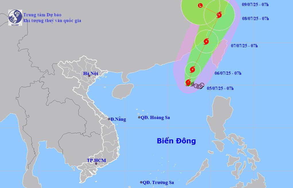
It is forecasted that by 7:00 a.m. on July 7, storm No. 2 will move in the North Northeast direction, accelerating to 15km/h. The center of the storm is located at about 25.1 degrees North latitude - 119.5 degrees East longitude, in the waters of Fujian province (China).
The strongest wind near the storm center is level 10, gusting to level 12. Natural disaster risk level: level 3 for the northeastern sea area of the North East Sea.
At 7:00 a.m. on July 8, storm No. 2 moved in the North Northeast direction, maintaining a speed of 15km/h. The center of the storm is located at about 28.2 degrees North latitude - 121.0 degrees East longitude, in Zhejiang Province (China).
It is forecasted that in the next 72 to 96 hours, the storm will move in a West-Northwest direction at a speed of about 10km/h and gradually weaken into a low pressure area.
Due to the influence of storm No. 2 DANAS, the northeastern sea area of the North East Sea will have storms and strong winds of level 7-8, the area near the storm's eye will have level 9-11, gusts of level 13, and rough seas. Waves are 4.0-6.0m high.
Ship operating in the above-mentioned dangerous areas are likely to be affected by thunderstorms, whirlwinds, strong winds, and large waves.
People and tourists planning to visit Hong Kong (China), Taiwan (China), Zhejiang province (China) and neighboring areas should pay attention to weather forecasts and check flight schedules to avoid storms.


