Meteorological agencies in China, Japan and the Philippines are all monitoring Kong-rey, and are uncertain about its path.
In its weather forecast at 5am on October 28, the Philippine Atmospheric, Geophysical and Astronomical Services Administration (PAGASA) said tropical storm Kong-rey (local name Leon) was about 40km east of Central Luzon.
The storm was moving west at 10 km/h, with maximum sustained winds of 85 km/h near the center and gusts to 105 km/h.
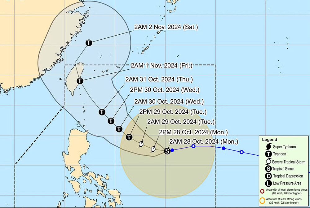
Based on forecast models, PAGASA said the storm could pass through the Batanes region on October 30 or 31. The storm is expected to intensify by the afternoon of October 28 and become a strong typhoon at sea.
China's National Meteorological Center said that Kong-rey could become a strong typhoon or super typhoon. This is the 21st typhoon of the 2024 typhoon season in this country.
According to the China Weather Administration (CWA), the storm's center is forecast to move north on October 28 or 29.
Typhoon Kong-rey will approach the eastern sea of Taiwan (China), bringing rain to the northern and northeastern regions of the island from October 30 to November 1.

Residents and tourists in the above areas are advised to regularly monitor weather forecasts, comply with recommendations from authorities and update announcements from airlines, trains, etc. to be proactive about their schedules and ensure safety.


