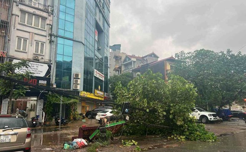
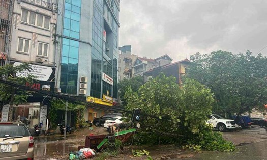
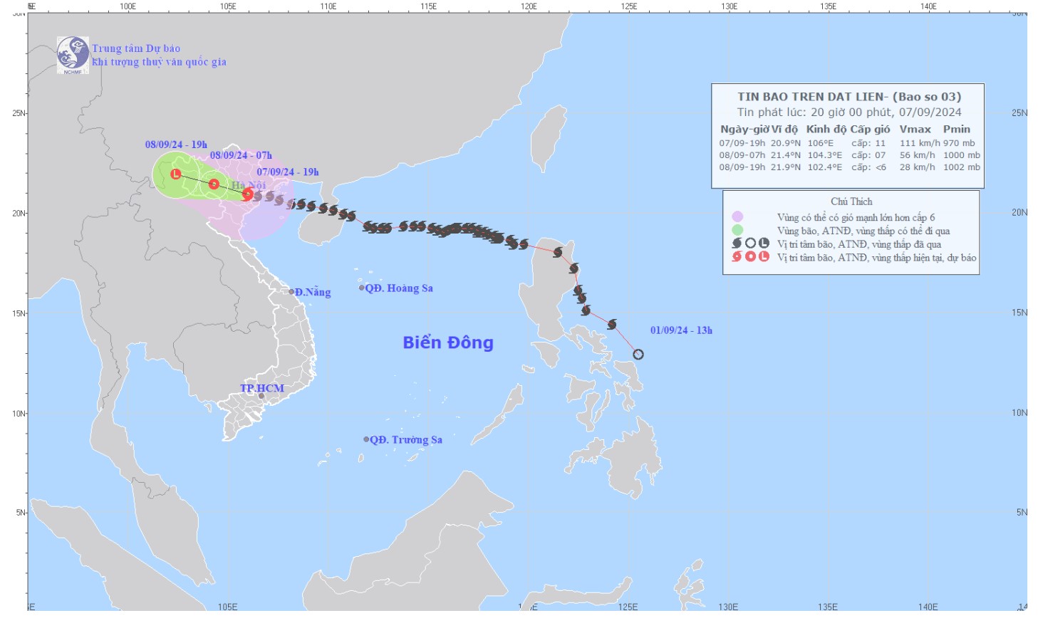
According to the latest announcement from the National Center for Hydro-Meteorological Forecasting, at 10:00 p.m. on September 7, the center of storm No. 3 was located at about 21.0 degrees North latitude; 105.5 degrees East longitude, on land in the Northern Delta region.
The strongest wind near the storm center is level 8-9 (62-88km/h), gusting to level 11, moving in the West Northwest direction, speed 15-20km/h.
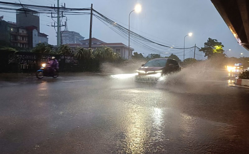
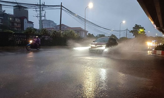
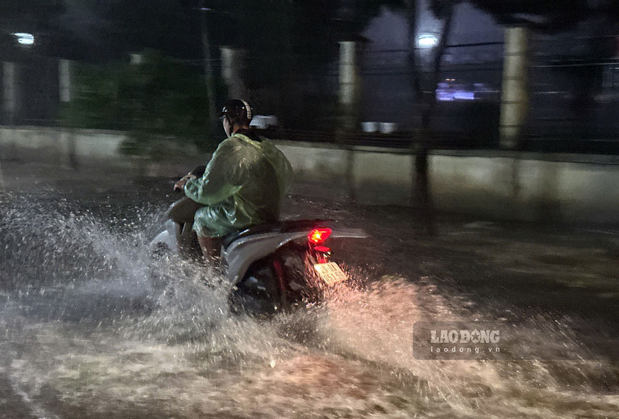
Due to the impact of storm No. 3 Yagi, Hanoi's inner city area is currently facing heavy to very heavy rain.
According to forecasts, in the next 3-6 hours, this area and surrounding areas will continue to have heavy rain with expected rainfall ranging from 50-100mm, possibly exceeding 150mm in some places. This rain is likely to cause serious flooding on many inner-city streets.
Inner-city areas of Hanoi at high risk of flooding include:
Tay Ho District with streets such as Thuy Khue, Duong Quang Ham, Phu Xa... is at risk of flooding from 30-50cm deep.
Ba Dinh District includes areas at risk of deep flooding in Thanh Cong, Huynh Thuc Khang, La Thanh, Lieu Giai, Dien Bien Phu, Nui Truc, Ngoc Khanh, and Nguyen Truong To.
Hoan Kiem District is at risk of deep flooding on streets such as Phung Hung, Lien Tri - Nguyen Gia Thieu, Ta Hien - Luong Ngoc Quyen intersection, Dinh Liet street, Nguyen Sieu street - Gach alley, Tong Dan, Quang Trung - Tran Quoc Toan intersection, Tho Nhuom, Ba Trieu, Dien Bien Phu, Quan Thanh, Duong Thanh - Hang Non intersection.
Dong Da District includes the streets of Bui Xuong Trach, Huynh Thuc Khang, Thai Ha, Chua Boc, Pham Ngoc Thach, Ton Duc Thang, Kham Thien, Le Duan, Van Mieu - Quoc Tu Giam, and Kim Lien.
Thanh Xuan District with areas of Le Trong Tan, Hoang Van Thai, Nguyen Ngoc Nai, Vuong Thua Vu, Nguyen Van Troi, Nguyen Tuan, Luong The Vinh, Nguyen Xien, Quan Nhan - Vu Trong Phung, Nguyen Trai, Nguyen Huy Tuong, Phung Khoang, To Huu street (section from Luong The Vinh to Trung Van).
Hai Ba Trung District includes the streets of Nguyen Khoi, Lac Trung, Mac Thi Buoi, Hang Chuoi, Tran Xuan Soan, Thanh Nhan, and Yec-xanh.
Cau Giay District with areas of Duong Dinh Nghe-Nam Trung Yen intersection (behind Keangnam building), Hoang Quoc Viet (near Electricity University), Phan Van Truong, Phung Chi Kien, Tran Binh, Hoa Bang street.
Hoang Mai District includes Thinh Liet Street, Den Lu Street, Hoang Mai Street, Vinh Hung Street, Truong Dinh, Linh Nam, Dinh Cong.
Bac Tu Liem District with Ke Ve, Tran Cung streets and Nhon station.
Nam Tu Liem District includes Do Duc Duc Street, Phung Khoang Street, and the residential underpass through Thang Long Avenue.
Long Bien District with areas of Co Linh, Dam Quang Trung, Nguyen Van Cu, Ngoc Lam, Hoa Lam (near lane 80).
Ha Dong District with Trieu Khuc Street, Quyet Thang Street, To Hieu Street, Yen Nghia Street.
The flood risk is forecast at level 1, which means the risk is low but people still need to be vigilant and prepared. Vehicles traveling on flooded streets will have difficulty, and flooding may cause local congestion.
Rainfall is generally 50-80mm, higher in some places. Warning of flooding characteristics, in the coming hours, Hanoi city and neighboring areas will continue to have moderate to heavy rain, with total accumulated rainfall generally ranging from 30-60mm, in some places over 70mm.
Hanoi has operated 9 drainage pumping stations with 32 pumps, with a total pumping capacity of about 79,300 m3/h to prevent heavy rains from causing flooding in low-lying areas, urban areas and industrial parks.
The amount of rain is forecast to be less than the amount of rain in late October 2008 that caused the historic flood in Hanoi. The total amount of rain in the Hanoi area is commonly from 350 - 550 mm.
However, when it rains for a long time due to the influence of storm No. 3 Yagai - which is likely to weaken into a low pressure area, water can still rise slowly, causing serious flooding.
People need to take the initiative to prevent flooding. Tourists planning to travel to Hanoi from September 8-10 should pay attention to weather forecasts.
According to the National Center for Hydro-Meteorological Forecasting, from the night of September 7 to the morning of September 8, the Northeast and Thanh Hoa will have heavy to very heavy rain with common rainfall of 70-150mm, locally over 300mm.
Afternoon and night of September 8: moderate rain, locally heavy rain and thunderstorms with common rainfall of 20-50mm, locally over 100mm; mountainous areas have heavy rain, locally very heavy rain with common rainfall of 60-120mm, locally over 250mm.
In the Northwest, from the night of September 7 to the morning of September 9, there will be heavy to very heavy rain with common rainfall of 100-350mm, locally over 500mm.
Heavy rains can cause flooding in low-lying areas; flash floods in small rivers and streams, and landslides on steep slopes.
Residents and tourists need to monitor weather conditions regularly, limit going out during heavy rain, prepare travel plans and take safety measures.