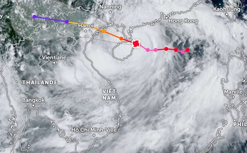
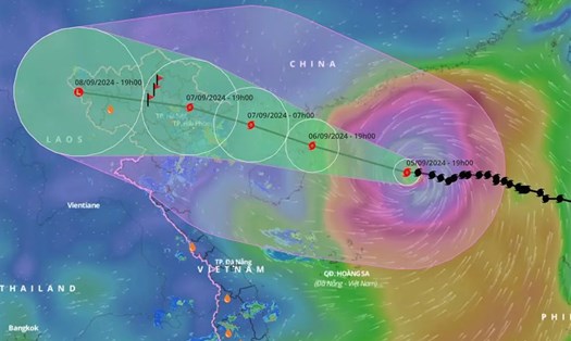
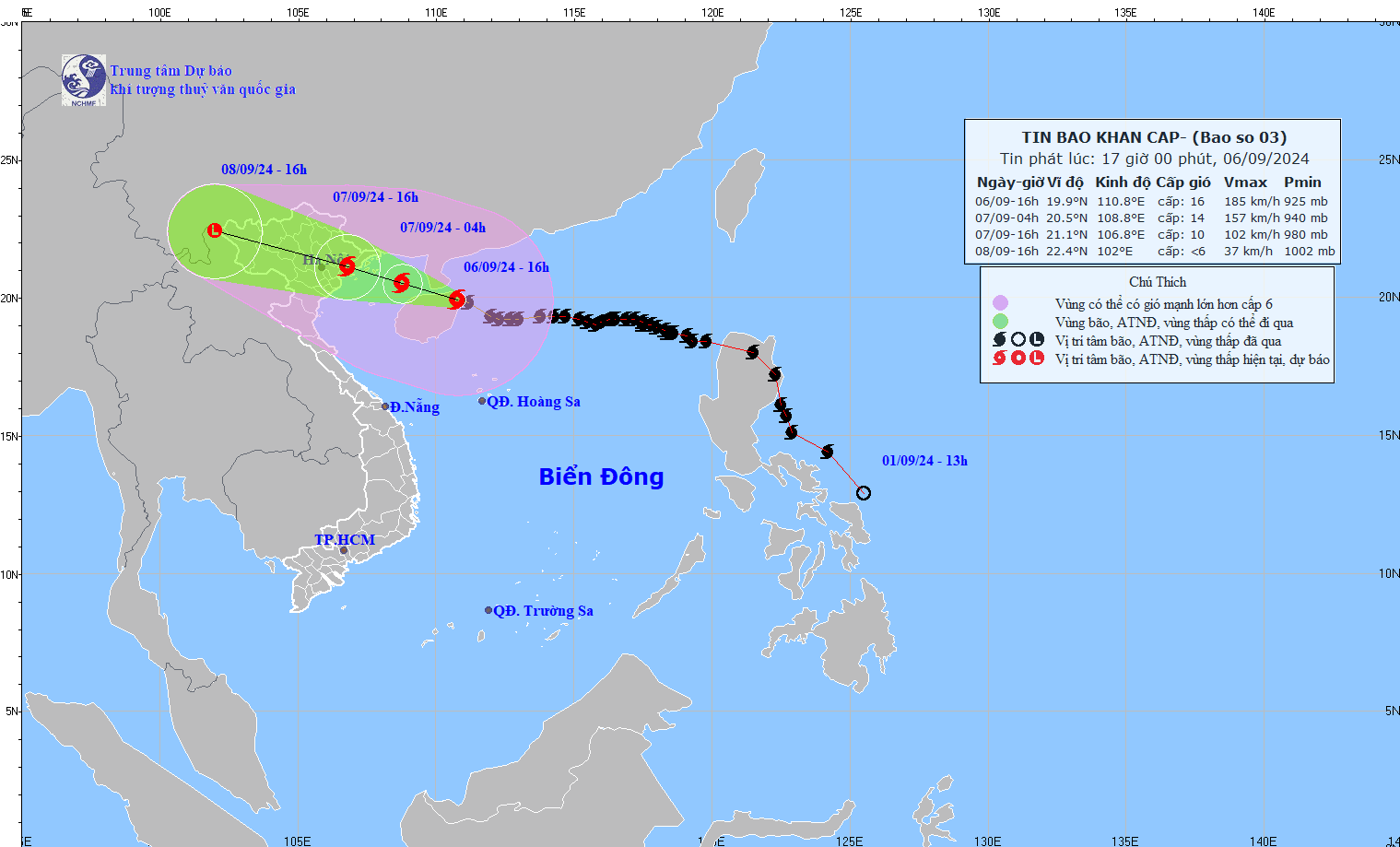
According to the National Center for Hydro-Meteorological Forecasting, at 4:00 p.m. on September 6, the center of storm No. 3 was located at approximately 19.9 degrees North latitude; 110.8 degrees East longitude, on the mainland northeast of Hainan Island (China); approximately 420km East Southeast of Quang Ninh. The strongest wind near the center of the storm was level 16 (184-201km/h), gusting to level 17, moving in a West Northwest direction at a speed of 15-20km/h.
Storm movement direction
At 4:00 a.m. on September 7, the storm center is forecast to be at about 20.5 degrees North latitude and 108.8 degrees East longitude, moving West Northwest at a speed of 15-20 km/h, entering the North Gulf of Tonkin. The storm's location is forecast to be in the North Gulf of Tonkin, about 200 km East Southeast of Quang Ninh. The intensity is level 14, gusting to level 17.
At 4:00 p.m. on September 7, the storm center continued to move to 21.1 degrees North latitude and 106.8 degrees East longitude, on the mainland of Quang Ninh-Thai Binh provinces. The intensity is level 10-11, gusting to level 13.
Level 4 disaster risk warning for coastal waters and mainland of Quang Ninh and Hai Phong; and level 3 for Bac Bo Gulf, coastal waters and mainland of Thai Binh, Nam Dinh, Ninh Binh and Thanh Hoa provinces.
Heavy rain, thunderstorms, tornado warning
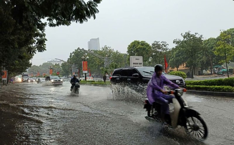
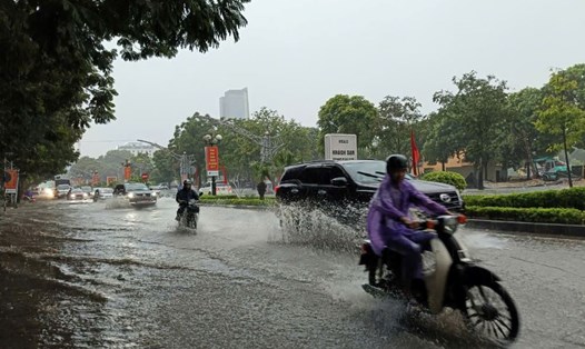
From the night of September 6 to the morning of September 9, in the Northern region and Thanh Hoa, there is a possibility of heavy rain with total rainfall ranging from 100-350mm, in some places over 500mm (the heaviest rain in the Northeast concentrated during the day and night of September 7; in the Northwest from the evening of September 7 to the night of September 8).
Heavy rains can cause flooding in low-lying areas; flash floods in small rivers and streams, and landslides on steep slopes.
Due to the influence of the wide storm circulation, on the night of September 6, in the Northwest region, the area from Thanh Hoa to Thua Thien Hue needs to be on guard against the risk of thunderstorms, tornadoes, and strong gusts of wind before the storm hits.
Wind Warning
From the night of September 6 and early morning of September 7, coastal areas from Quang Ninh to Thanh Hoa will have strong winds of level 6-7, then increasing to level 8-9, areas near the storm center will have winds of level 10-12, gusting to level 14; areas deep inland in the Northeast will have strong winds of level 6-8, gusting to level 9-11. The strongest winds will be from morning to evening of September 7.
The northwest sea area of the North East Sea on the night of September 6 still has strong winds of level 10-12, near the storm center of level 14-16, gusting over level 17; the sea is very rough. On September 7, the wind gradually decreases.
The Gulf of Tonkin (including Bach Long Vi island district) has strong winds of level 6-7. From the evening and night of September 6, the Gulf of Tonkin (including Bach Long Vi island district and Co To) will have winds gradually increasing to level 8-9, then increasing to level 10-11, near the storm center, winds of level 12-14, gusting to level 17; the sea is very rough.
Warning about waves and rising water
In the Gulf of Tonkin (including Bach Long Vi and Co To island districts), waves are 2.0-4.0m high, then increase to 3.0-5.0m, and 6.0-8.0m near the storm's eye.
From the night of September 6 and early morning of September 7, coastal waters from Quang Ninh to Thanh Hoa had waves 2.0-3.0m high, later increasing to 2.0-4.0m, near the storm center 3.0-5.0m.
Coastal areas from Thanh Hoa to Quang Ninh need to be on guard against storm surges of 0.5m (Thanh Hoa) - 2.0m (Quang Ninh) in the afternoon and night of September 7 and storm recedes, about 0.5m (Thanh Hoa) - 1.0m (Quang Ninh) appearing in the morning of September 7.
Low-lying coastal and estuary areas should be on guard against flooding due to rising water and large waves.
In this situation, people and tourists in localities expected to be directly affected by storm No. 3 Yagi need to strictly follow the instructions and recommendations of authorities; proactively monitor weather forecasts and implement measures to ensure safety and prevent natural disasters.