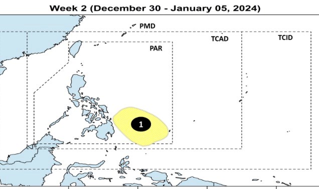
According to the latest typhoon forecast from the Philippine Atmospheric, Geophysical and Astronomical Services Administration (PAGASA) for the week of December 30, 2024 to May 1, 2025, a new low pressure area will form south of the Philippine Forecast Area (PAR). This low pressure area near the East Sea is forecast to have little chance of strengthening into a tropical storm.
PAGASA forecasts that tropical storm Pabuk (local name in the Philippines: Romina, name in Vietnam: storm number 10) active in the East Sea during the week of December 23-29 will move south of Vietnam before gradually weakening into a tropical depression.

Apart from Storm Pabuk, there is little chance of a new tropical depression or tropical storm forming in the PAR region in the last week of 2024.
Previously, PAGASA forecasted that 1 to 2 tropical storms would enter the Philippine forecast area in December. In mid-December, tropical depression Querubin formed in the PAR region of the Philippines but did not strengthen into a storm.
On December 22, Tropical Depression Romina appeared in the South China Sea, then strengthened into a tropical storm. This is the first time since 1963 that PAGASA has assigned a local name to a tropical depression outside the forecast area.
Pabuk is also the 10th storm to hit the East Sea in 2024. Currently, the storm is moving slowly near the sea area from Binh Thuan to Ba Ria - Vung Tau. The storm is expected to gradually weaken into a tropical depression and low pressure area in the next 24-36 hours.
Meteorological experts predict that coastal areas from the Central region to Ho Chi Minh City will have moderate rain, heavy rain, and in some places very heavy rain from December 24 to 29.
Residents and tourists from Ninh Thuan to Ba Ria - Vung Tau need to pay attention to weather forecasts and update the storm's direction to plan their travel schedule and outdoor activities appropriately, ensuring safety.


