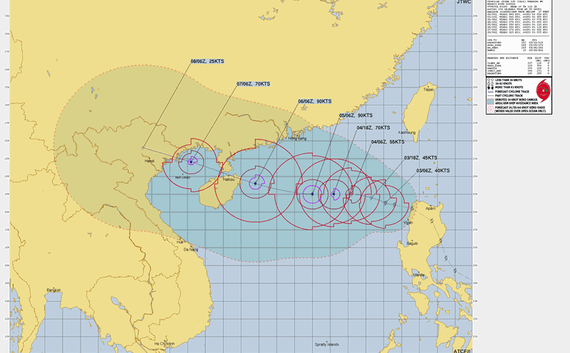
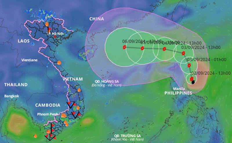
The National Center for Hydro-Meteorological Forecasting said that storm No. 3 (international name: storm Yagi) is one of the strongest storms in 2024 operating in the East Sea, and is likely to make landfall directly in the northern provinces with strong intensity.
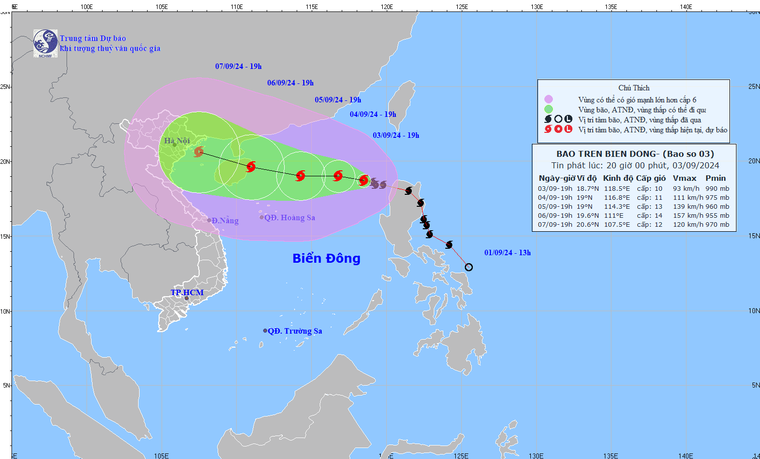
At 7:00 p.m. on September 3, the center of the storm was located at approximately 18.7 degrees North latitude; 118.5 degrees East longitude, in the eastern sea area of the North East Sea. The strongest wind near the center of the storm was level 10 (89-102 km/h), gusting to level 12, moving in the West Northwest direction, at approximately 10 km/h.
It is forecasted that at around 7pm on September 6, Typhoon Yagi will move in a West-Northwest direction at a speed of about 15km/h. The typhoon will be located at 19.6 degrees North latitude; 111.0 degrees East longitude on the eastern coastal area of Hainan Island (China).
Experts warn of level 4 natural disaster risk in the northern part of the North East Sea region.
From the next 72 to 120 hours, the storm will move mainly in the West Northwest direction, traveling 10-15km per hour, with little change in intensity, then gradually decreasing.
With its current trajectory, storm No. 3 is likely to make landfall in the Northern and North Central provinces between September 7 and 8.
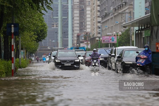
From September 7, the North is likely to experience a very heavy rain. The total rainfall is extremely high, up to 400 to 500 mm, including rain caused by storm circulation. During thunderstorms, there is a possibility of tornadoes, lightning and strong gusts of wind.
Eight years after the first storm (Mirinae) in 2016, the Northern region is once again facing a strong storm that is likely to reach super typhoon level. The Northern provinces, especially Quang Ninh, Hai Phong, Thai Binh, Nam Dinh, Ha Nam and Ninh Binh, need to proactively deploy storm prevention measures right now to protect lives and property.
The meteorological agency warned that storm No. 3 will continue to strengthen, with the strongest winds at sea possibly reaching level 13, gusting to level 16, in the coming days, moving rapidly towards Hainan Island (China) and the Gulf of Tonkin.
Experts warn of the risk of flooding in low-lying areas of provinces and cities such as Quang Ninh, Hai Phong, Thai Binh, Nam Dinh, Hai Duong, Hung Yen, Hanoi, Hoa Binh, Vinh Phuc, Thai Nguyen, Yen Bai. In particular, the northern mountainous provinces are at high risk of flooding due to torrential rains.
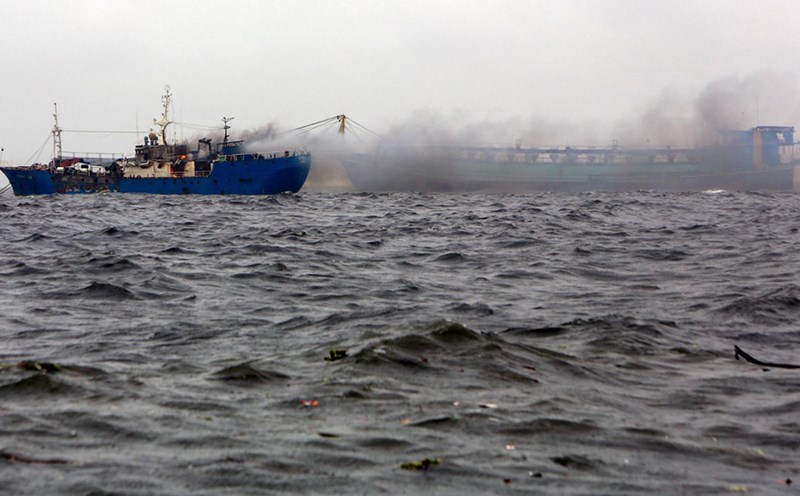
Due to the influence of the storm, the eastern sea area of the North East Sea has strong winds of level 8-9, the area near the eye of the storm has winds of level 10-11, gusting to level 13; the sea is very rough. From the night of September 4-6, storm No. 3 may reach very strong storm level in the northern sea area of the North East Sea, strong winds can reach level 14, gusting to level 17.
On September 3, Prime Minister Pham Minh Chinh issued an official dispatch directing ministries, branches and localities to urgently deploy responses to storm No. 3 in 2024. The official dispatch requested coastal provinces and cities to proactively provide timely information, direct and guide people to respond to storms and floods, focusing on ensuring safety for activities at sea and on islands, based on the actual situation and the potential impact of storms and floods in the locality.
Organize inspection, counting, proactively inform and guide vehicles and boats (including fishing boats, transport ships, and tourist boats) still operating at sea to know, not to enter or exit dangerous areas or to return to safe shelters; take measures to ensure safety for boats at anchorage areas.
Given the complex developments of Typhoon Yagi, residents and tourists need to pay attention to updates on the storm situation, affected areas and prepare preventive measures right now. Consider your travel schedule in the coming time, especially limit travel to the sea and provinces where Typhoon No. 3 is likely to make landfall; choose solid, safe accommodation and follow instructions from local authorities.