Routes where roads are completely banned (no vehicles are allowed to circulate, except for vehicles with badges for celebrations and priority vehicles):
A series of key routes in Ba Dinh, Hoan Kiem, Dong Da, Tay Ho districts include:
Ba Dinh area and vicinity: Hoang Hoa Tham; Thuy Khue (from Hung Vuong to Van Cao); Mai Xuan Thuong; Quan Thanh; Phan Dinh Phung; Hung Vuong; Thanh Nien; Hoang Van Thu; Doc Lap; Dien Bien Phu; Ba Huyen Thanh Quan; Chua Mot Cot; Le Hong Phong; Ong Ich Khiem; Ngoc Ha; Bac Son; Ton That Dam; Nguyen Canh Chan; Hoang Dieu; Nguyen Tri Phuong; Chu Van An; Ton Duc Thang; Cat Linh; Trinh Hoai Duc; Hang Chao; Tran Phu; Son Tay.
Hoan Kiem and Dong Da areas: Kim Ma; Lieu Giai; Van Cao; Nghi Tam; Yen Phu; Cua Bac; Doi Can; Doc La-Pho; Nguyen Thai Hoc; Le Duan; Tran Nhan Tong (from Le Duan to Quang Trung); Trang Thi; Hang Khay; Trang Tien; Co Tan; Phan Chu Trinh (from Hai Ba Trung to Trang Tien); Le Thanh Tong; Tong Dan (from Ly Dao Thanh to Trang Tien); Tran Quang Khai.
Some expanded routes: Tran Khanh Du; Quang Trung (from Ly Thuong Kiet to Trang Thi); Ly Thai To; Nguyen Huu Huan; Ngo Quyen (from State Bank Square to Trang Tien); Giang Vo; Lang Ha; Lang (from Lang Ha to Tran Duy Hung).
Temporarily banned routes:
Inside Ring Road I: all vehicles are temporarily banned (except for vehicles with protection badges, vehicles serving celebrations, priority vehicles, official vehicles, buses, garbage collection vehicles, and vehicles for incident handling)
From Ring Road I to Ring Road II: temporarily ban trucks with a capacity of 1.5 tons or more and passenger cars with 16 seats or more (except for priority vehicles, used for ceremonies, official services, buses, garbage trucks, official vehicles, etc.).
Routes with limited traffic:
From Ring Road II to Ring Road III: limit personal cars, motorbikes, and passenger cars with less than 16 seats at the above-mentioned time frames.
Some suburban routes from Ring Road III: National Highway 32, Cau Dien, Ho Tung Mau, Le Duc Tho, Le Quang Dao, Thang Long Avenue, Lang Tuong Road, National Highway 21A, Ho Chi Minh Road, National Highway 6, Quang Trung, Tran Phu, Nguyen Trai, Provincial Road 419, 429, Vo Nguyen Giap, National Highway 18; Traffic is restricted (except for buses, garbage trucks, incident handling vehicles, vehicles with badges for celebrations).
On these routes, buses, garbage trucks, incident handling vehicles and vehicles serving celebrations are allowed to operate, the rest will be limited.
The route of the A80 parade and march blocks
Nghi Truong block: follow Nguyen Thai Hoc - Trang Thi - Trang Tien direction, end at Thang Tam Revolution Square.
The infantry (Army, Police, militia, foreign groups) withdrew in 3 main directions:
Nguyen Thai Hoc Kim Ma Lieu Giai Van Cao Deputy Director of Quan Ngua.
Nguyen Thai Hoc - Trang Thi - Trang Tien - August Revolution Square.
Nguyen Thai Hoc Le Duan Thong Nhat Park.
Mobile Police and Cavalry blocks: Follow Le Hong Phong - Ngoc Ha road, to Bach Thao Park.
Hong Ky Block: Do Le Hong Phong - Doi Can - Giang Van Minh - Kim Ma - Lieu Giai, about Quan Ngua.
Mass, Culture - Sports: Go straight through the stage, end at Hang Day Stadium (Nguyen Thai Hoc - Trinh Hoai Duc model car).
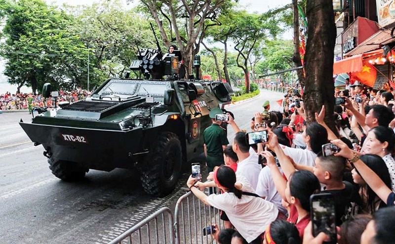
Motor vehicle block: Divided into 2 main routes:
Cua Bac - Nghi Tam - Au Co - Vo Chi Cong - Duong Lang - Tran Duy Hung - Thang Long Avenue - Le Quang Dao - F1 racetrack.
Nguyen Thai Hoc Giang Vo Duong Lang Tran Duy Hung Thang Long Avenue Le Quang Dao F1 racetrack.
Location for gathering parading andideing blocks
Nghi Truong Block: August Revolution Square
Military, Police, Militia, Foreign Forces: Quan Ngua Stadium
Part of the walking block: Thong Nhat Park
Mobile Police, Horse soldiers: Bach Thao Park
Hong Ky block: Quan Ngua Stadium (towards Doi Can)
Public, Cultural - Sports block: Hang Day Stadium
Mechanical block, artillery vehicles: F1 racetrack

