Storm No. 3 is strengthening very quickly, continuing to increase in intensity in the next 24 hours.

AN AN |

The meteorological agency said that storm No. 3 has increased in intensity very quickly and is forecast to continue to increase in level.

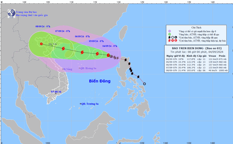
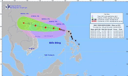
Latest update from the National Center for Hydro-Meteorological Forecasting, at 10:00 a.m. on September 4, the center of storm No. 3 was located at about 19 degrees north latitude; 117.5 degrees east longitude, in the eastern sea of ​​the North East Sea, about 730km east of Hainan Island (China).

The strongest wind near the storm center is level 12 (118-133km/h), gusting to level 15, moving west-northwest, about 10km/h.

It is forecasted that in the next 24 hours , storm No. 3 will move west-northwest at a speed of 10 - 15 km/h. At 10:00 on September 5, the center of the storm will be at about 19.3 degrees north latitude - 115.2 degrees east longitude; about 470 km east of Hainan Island (China).

The strongest wind near the storm center is level 13 - 14, gusting to level 17.

It is forecasted that in the next 48 hours , storm No. 3 will move west-northwest at a speed of 10 - 15 km/h. At 10:00 on September 6, the center of the storm will be at about 19.7 degrees north latitude - 111.9 degrees east longitude; about 120 km east of Hainan Island (China).

The strongest wind near the storm center is level 14 - 15, gusting to level 17.

It is forecasted that in the next 72 hours , storm No. 3 will move west-northwest at a speed of 15 - 20km/h. At 10:00 on September 7, the center of the storm will be at about 20.5 degrees north latitude - 107.9 degrees east longitude; in the Gulf of Tonkin.

The strongest wind near the storm center is level 12 - 13, gusting to level 16.

From the next 72 to 120 hours , the storm will move mainly in the west-northwest direction, traveling 15 - 20km per hour, and its intensity will continue to decrease.

Regarding the impact of the storm , the North East Sea has strong winds of level 9-11, near the eye of the storm, winds of level 12-14, gusts of level 17; rough seas. From September 5 to 6, storm No. 3 continues to increase in intensity, strong winds can reach level 15, gusts above level 17 near the eye of the storm.

In the next 24 hours, the eastern sea of ​​the North East Sea will have waves 5-7m high, and 7-9m near the storm center. From September 5-6, they may gradually increase to 9-11m. The sea will be rough. Ships operating in the above-mentioned dangerous areas are likely to be affected by strong winds and large waves.

AN AN
TIN LIÊN QUAN

Dự báo mới nhất đường đi và cường độ của bão số 3 Yagi

NHÓM PV |

Sáng nay 4.9, cơ quan khí tượng của Việt Nam đã cập nhật vị trí, đường đi và cường độ của bão số 3 Yagi.

Dự báo thời điểm bão số 3 Yagi mạnh nhất, biển động dữ dội

AN AN |

Cơ quan khí tượng của Việt Nam nhận định bão số 3 Yagi có thể đạt cường độ mạnh nhất trong 2 ngày tới.

Bão số 3 Yagi rất mạnh, dự báo kịch bản đổ bộ

NHÓM PV |

Đại diện cơ quan khí tượng cảnh báo bão số 3 Yagi có thể đạt cường độ rất mạnh và hiện tại có 2 kịch bản đường đi.

Dự án 3 lần lùi tiến độ bị thanh tra toàn diện tại Quảng Nam

Lam Duy |

Dự án của Công ty TNHH Thương mại và Dịch vụ tổng hợp Viesky bị thanh tra toàn diện tại Quảng Nam có 3 lần xin điều chỉnh tiến độ.

Một nhà hàng ở Yên Bái bị tố chặt chém đoàn từ thiện bão lũ

Trần Bùi |

Một nhà hàng trên địa bàn TP Yên Bái bị đoàn khách từ thiện tố "chặt chém" khi thu hóa đơn tới gần 5 triệu đồng cho bữa cơm 12 người.

Bà Nguyễn Phương Hằng được ra tù vào hôm nay

ĐÌNH TRỌNG |

Cơ quan chức năng tại tỉnh Bình Dương cho biết, sáng nay (19.9), bà Nguyễn Phương Hằng được ra tù sau khi được xét giảm án.

Bão số 4 chưa vào, cây cối ở Quảng Bình đã bật gốc

CÔNG SÁNG |

Bão số 4 chưa vào, cây cối tại đường Võ Thị Sáu (TP Đồng Hới, tỉnh Quảng Bình) đã bật gốc.

Ứng phó bão số 4, chủ động với các tình huống xấu nhất xảy ra

PHẠM ĐÔNG |

Thủ tướng Chính phủ yêu cầu quyết liệt ứng phó bão số 4 theo phương châm "bốn tại chỗ", chủ động xử lý các tình huống xấu nhất có thể xảy ra.

Latest forecast of the path and intensity of storm No. 3 Yagi

NHÓM PV |

This morning, September 4, Vietnam's meteorological agency updated the location, path and intensity of storm number 3 Yagi .

Forecast of the time when storm No. 3 Yagi is strongest, the sea is very rough

AN AN |

Vietnam's meteorological agency said that storm No. 3 Yagi could reach its strongest intensity in the next 2 days.

Typhoon No. 3 Yagi is very strong, forecast scenario of landfall

NHÓM PV |

The meteorological agency representative warned that storm No. 3 Yagi could reach very strong intensity and currently has 2 path scenarios.