Tropical depression officially makes landfall

Chí Long |

The low pressure area in the Pacific Ocean has officially made landfall on the small island south of the Solomon Islands.

According to storm news, the latest low pressure from the Joint Typhoon Warning Center (JTWC), a low pressure has passed through a small island in the Solomon Islands to head towards Kirakira Island.

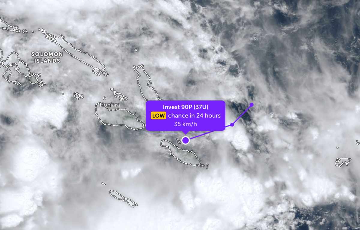
As of this morning April 1st, the center of the low pressure bearing the symbol Invest 90P (37U) is currently off the southern Solomon Islands.

The strongest wind near the center of the low pressure remains at about 35 km/h. JTWC forecasts that the low pressure is unlikely to strengthen into a tropical depression or storm in the next 24 hours.

Due to the influence of the low pressure, there are scattered thunderstorms in Kirakira and some nearby small islands. Tourists in this area need to be wary of thunderstorms accompanied by tornadoes, lightning, and strong gusts of wind.

Cập nhật hướng đi của áp thấp trên Thái Bình Dương. Ảnh: JTWC
Update on the direction of the low pressure in the Pacific Ocean. Photo: JTWC

In the East Sea, according to the National Center for Hydro-Meteorological Forecasting, the Northern Gulf area will have scattered rain in the morning, with thunderstorms in some places; then it will decrease to showers and thunderstorms in a few places. In thunderstorms, it is necessary to prevent tornadoes and strong gusts of wind. Visibility is over 10km, reduced to 4-10km when it rains. Northeast wind level 4-5, waves 1.0-2.0m high.

Southern Gulf of Tonkin has showers and thunderstorms in some places, visibility over 10km. Southeast to easterly wind level 4, waves 1.0-2.0m high. From Southern Quang Tri to Quang Ngai there is rain in some places, visibility over 10km. Southeast wind level 4-5, waves 1.0-2.0m high.

The area from Gia Lai to Khanh Hoa, Lam Dong to Ca Mau and Ca Mau to An Giang is generally rainless, visibility over 10km. Wind is light to level 4, waves are 0.5-1.5m high.

The North East Sea area and the Hoang Sa special zone area are rainless, visibility over 10km, south to southwest wind level 4, waves 0.5-2.0m high.

People and tourists planning to visit the above sea areas should pay attention to weather forecasts. Follow local instructions to have a safe trip, avoid heavy rain and big waves at sea causing danger.

Chí Long
TIN LIÊN QUAN

Tropical depression officially becomes storm Indusa strengthens fiercely

|

The tropical depression over the Indian Ocean has strengthened into tropical storm Indusa, causing widespread rain.

Northern region officially welcomes cold air, risk of ice rain

|

Weak cold air is pouring into the North, accompanied by the risk of extreme weather patterns such as thunderstorms, lightning, hail, and strong gusts of wind.

Cold air compresses low pressure trough, forecast very heavy rain in the area

|

Weak cold air is moving southward, forecasting widespread thunderstorms in the North.

New low pressure officially strengthens into a storm at sea

|

Depression 99S over the southwest Indian Ocean officially strengthens into tropical storm 29S, likely to intensify rapidly in the coming days.

Depression strengthens rapidly, forecast to soon become a storm

|

The low pressure area over the Indian Ocean is likely to strengthen rapidly, tourists need to monitor weather developments when planning their travel.

Tropical depression officially becomes storm Indusa strengthens fiercely

Dương Đông |

The tropical depression over the Indian Ocean has strengthened into tropical storm Indusa, causing widespread rain.

Northern region officially welcomes cold air, risk of ice rain

Dương Đông |

Weak cold air is pouring into the North, accompanied by the risk of extreme weather patterns such as thunderstorms, lightning, hail, and strong gusts of wind.

Cold air compresses low pressure trough, forecast very heavy rain in the area

Dương Đông |

Weak cold air is moving southward, forecasting widespread thunderstorms in the North.

New low pressure officially strengthens into a storm at sea

Dương Đông |

Depression 99S over the southwest Indian Ocean officially strengthens into tropical storm 29S, likely to intensify rapidly in the coming days.

Depression strengthens rapidly, forecast to soon become a storm

Dương Đông |

The low pressure area over the Indian Ocean is likely to strengthen rapidly, tourists need to monitor weather developments when planning their travel.