New low pressure forms, forecast to strengthen in the next 24 hours

Chí Long |

It is forecast that a new low pressure area has formed in the Western Pacific Ocean.

According to storm news, the latest low pressure from the Joint Typhoon Warning Center (JTWC), this morning March 26, a new low pressure has formed in the Pacific Ocean.

The center of the low pressure is located in the western Pacific Ocean, near the Marshall Islands. The strongest wind near the center of the low pressure reaches 30 km/h.

JTWC forecasts that the low pressure is unlikely to develop strongly into a tropical depression or storm in the next 24 hours.

Áp thấp mới hình thành trên biển Thái Bình Dương. Ảnh: JTWC
New low pressure formed in the Pacific Ocean. Photo: JTWC

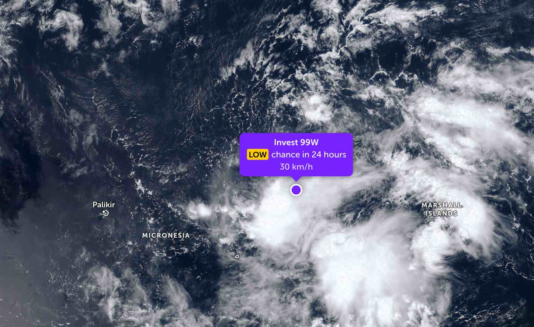
Because it is still quite far from the mainland, the low pressure has not significantly affected the weather on neighboring islands.

Meanwhile, Typhoon Narelle has intensified violently in the Indian Ocean, becoming a tropical storm of level 4. The strongest wind near the storm center reached 195 km/h, approaching super typhoon level.

The eye of the storm is currently off the coast of Port Hedland, in the Pilbara region, Western Australia. In the past 6 hours, the storm has moved in a Southwest direction at a speed of 19 km/h. Significant wave height reaches a maximum of 12.2 m.

JTWC forecasts storm Narelle will strengthen to super typhoon level this afternoon March 26 (local time), with winds up to 220 km/h before making landfall again in the Carnarvon coastal area (Australia).

Bão Narelle sắp mạnh lên thành siêu bão. Ảnh: JTWC
Typhoon Narelle is about to strengthen into a super typhoon. Photo: JTWC

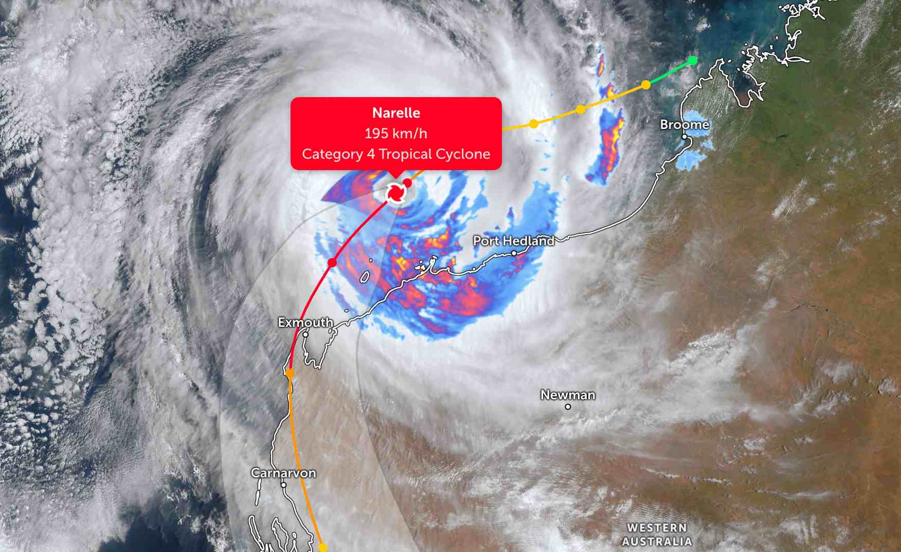
The Australian Meteorological Administration does not rule out the possibility that the storm may reach level 5 intensity in a short time.

Senior forecaster Jessica Lingard said that this storm has a large radius of strong winds. Today, the storm is likely to continue moving southwest, approaching the Pilbara coast.

By the end of the day, strong winds with potential damage will make landfall in Exmouth and Onslow, with gusts of up to 275 km/h.

The time is likely when the storm will make landfall late Friday night, around Shark Bay area.

The super typhoon is likely to begin weakening tomorrow as it moves further south, gliding over the coast near Carnarvon, and may weaken to Category 3 tomorrow evening before making landfall in Shark Bay area later in the night," she said.

People and tourists planning to visit Shark Bay or near the storm's path should pay attention to weather forecasts. Check flight schedules and follow local instructions to ensure safety.

Chí Long
TIN LIÊN QUAN

Typhoon 2026 forecast: Risk of strong storms and extreme weather increases

|

2026 is assessed to have storm and extreme weather fluctuations, posing high risks to tourism activities, especially at sea destinations.

Super typhoon Narelle officially revealed, winds destroy more than 275km/h when making landfall

|

Super typhoon Narelle is rapidly intensifying, forecast to make landfall in Western Australia with gusts of up to 275 km/h.

Forecast of low pressure, storms appearing in the East Sea and extreme weather

|

The possibility of tropical depressions or storms appearing in the East Sea is assessed as low in the next month.

Tropical depression officially strengthens into storm for the 2nd time

|

The tropical depression weakened from Hurricane Narella has strengthened into a storm for the second time.

Tropical depression is about to strengthen into a storm when entering the sea

|

It is forecast that the tropical depression weakened from Typhoon Narelle will strengthen again, with the possibility of becoming a storm in the next 24 hours.

Typhoon 2026 forecast: Risk of strong storms and extreme weather increases

Dương Đông |

2026 is assessed to have storm and extreme weather fluctuations, posing high risks to tourism activities, especially at sea destinations.

Super typhoon Narelle officially revealed, winds destroy more than 275km/h when making landfall

Dương Đông |

Super typhoon Narelle is rapidly intensifying, forecast to make landfall in Western Australia with gusts of up to 275 km/h.

Forecast of low pressure, storms appearing in the East Sea and extreme weather

Dương Đông |

The possibility of tropical depressions or storms appearing in the East Sea is assessed as low in the next month.

Tropical depression officially strengthens into storm for the 2nd time

Chí Long |

The tropical depression weakened from Hurricane Narella has strengthened into a storm for the second time.

Tropical depression is about to strengthen into a storm when entering the sea

Chí Long |

It is forecast that the tropical depression weakened from Typhoon Narelle will strengthen again, with the possibility of becoming a storm in the next 24 hours.