According to the latest storm and low pressure news from the Philippine Atmospheric, Geophysical and Astronomical Services Administration (PAGASA), Typhoon Nokaen near the East Sea has weakened into a tropical depression.
As of 8 am on January 20, the position of the center of the tropical depression is 17.8 degrees North latitude - 129.1 degrees East longitude, inside the Philippine Responsibility Area (PAR).
The strongest wind near the center of the tropical depression reached 55 km/h, gusting up to 70 km/h. The low pressure is moving in the Northeast direction at a speed of 10 km/h.
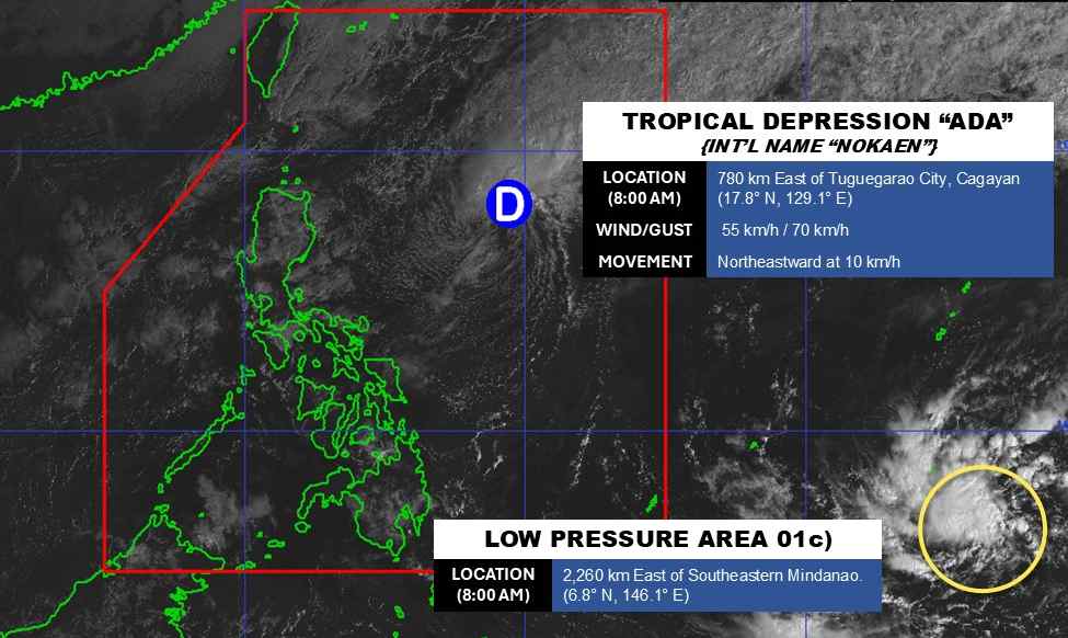
Meanwhile, another low pressure area has appeared outside the PAR area. The center of the low pressure is located at about 6.8 degrees North latitude - 146.1 degrees East longitude, about 2,260 km southeast of the eastern Mindanao.
The strongest wind near the center of the low pressure reaches 30 km/h. The low pressure is unlikely to become a tropical depression in the next 24 hours.
Due to being quite far away, the low pressure has not affected the mainland Philippines.
In the East Sea, according to the National Center for Hydro-Meteorological Forecasting, early in the morning of January 20, the sea area northeast of the Northern East Sea area had strong Northeast winds at level 6, sometimes level 7.
Forecast for the day and night of January 20, the North East Sea area (including the Hoang Sa special zone sea area) will gradually strengthen to level 6; especially the East level 6, sometimes level 7, gusts level 8-9. Sea is rough; waves are commonly 3.0-5.0 m high.
On January 21st, day and night, the North East Sea area will have waves of 4.0-6.0 m high, strong sea waves. In the Gulf of Tonkin, the Northeast wind will gradually strengthen to level 6, gusting to level 7-8; waves 2.0-3.0 m high.
From the evening of January 21, the sea area from South Quang Tri to Khanh Hoa and the Central East Sea area will have strong Northeast winds at level 6, gusts at level 7-8; waves 2.5-3.5 m high, especially the Central East Sea area 3.0-5.0 m, rough seas.
Faced with the complicated developments of the tropical depression and strong winds in the East Sea, people, fishermen and ships operating at sea need to closely monitor weather forecasts, proactively prevent strong winds and big waves.
Tourists should limit participation in sea and island tourism activities in the coming days, especially in the Northern East Sea area, the Gulf of Tonkin and the sea area from South Quang Tri to Khanh Hoa. Follow local instructions to avoid storms and big waves at sea that are dangerous.


