Strong tropical depression turns into storm, suddenly changes direction

Ninh Phương |

The tropical depression weakened from Typhoon Nokaen intensified again, reaching maximum wind speeds of about 75 km/h.

According to the latest storm news from the Joint Typhoon Warning Center (JTWC), tropical depression Ada (Philippine name) located about 640 km east-northeast of Manila has developed again into Typhoon Nokaen after about a day of weakening.

In the past 6 hours, the storm has moved in a Northeast direction at a speed of 17 km/h. The highest wave near the storm center reached 5.2 m, causing danger to maritime activities.

In the next 2 days, environmental conditions will still be relatively favorable for the storm to slightly increase in intensity, reaching a maximum wind speed of about 75 km/h. However, from after this milestone, increased dry air and high-level winds will cause the storm to weaken quickly and may dissipate within the next 3 days.

Meanwhile, the Philippine Atmospheric, Geophysical and Astronomical Services Administration (PAGASA) forecasts that the storm will change direction to the East-Southeast from the evening of January 2 to January 21.

The strongest wind in the area near the center is about 55 km/h, gusting at 70 km/h. The wind radius extends up to 300 km from the center of the storm.

Ap thap nhiet doi Ada manh thanh bao tro lai, tam bao o khoang 16,4 do Vi Bac, 126,5 do Kinh Dong. Anh: PAGASA
Tropical depression Ada strengthens into a storm again, the storm's center is at about 16.4 degrees North latitude, 126.5 degrees East longitude. Photo: PAGASA

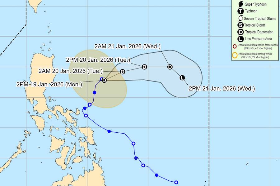
Due to the impact of dry air from monsoons, this system is forecast to gradually weaken and may degrade to a low pressure area in the next 48 - 72 hours.

Strong winds and rough seas affect the islands and northern coast of the Philippines. gusts of 50 - 100 km/h may occur in coastal and highland areas such as Batanes, Babuyan Islands, Ilocos Norte, Cagayan, Aurora, Metro Manila, Visayas region...

Tourists planning to visit the Philippines should regularly update storm forecasts and latest weather forecasts. Sea tourism, coral diving and high-speed cruises may be canceled or postponed due to strong winds and high waves.

Travel agencies and airlines need to proactively adjust schedules, notify passengers early and ensure safety plans, especially at coastal destinations and small islands.

Ninh Phương
TIN LIÊN QUAN

New update on Typhoon Nokaen near the East Sea

|

Typhoon Nokaen is forecast to gradually change direction away from the mainland Philippines.

Typhoon Nokaen causes widespread rain as it approaches mainland

|

Typhoon Nokaen makes a whirlwind near the East Sea, causing widespread rain.

New low pressure area appears, forecasting more storms to form next week

|

A new low pressure offshore the South Pacific, is highly likely to develop into a strong tropical storm off the coast of Australia early next week.

Low pressure series of storms continuously forming right in January

|

Forecast of continuous low pressure, tropical depression and storms in the Indian Ocean and Pacific Ocean in January.

New update on Typhoon Nokaen near the East Sea

Chí Long |

Typhoon Nokaen is forecast to gradually change direction away from the mainland Philippines.

Typhoon Nokaen causes widespread rain as it approaches mainland

Chí Long |

Typhoon Nokaen makes a whirlwind near the East Sea, causing widespread rain.

New low pressure area appears, forecasting more storms to form next week

Ninh Phương |

A new low pressure offshore the South Pacific, is highly likely to develop into a strong tropical storm off the coast of Australia early next week.

Low pressure series of storms continuously forming right in January

Chí Long |

Forecast of continuous low pressure, tropical depression and storms in the Indian Ocean and Pacific Ocean in January.