According to the latest storm news from the Joint Typhoon Warning Center (JTWC), the tropical depression Invest 94P (Tropical Low 14U) is operating in the Coral Sea and is highly likely to develop into a tropical storm in the next 24 hours.
Currently, the strongest wind near the center reaches 45-50 km/h.
Satellite data recorded winds of 35-45 km/h surrounding the east of the tropical depression. In addition, a strong wind range of up to 46 km/h was detected about 207 km northwest of the center, indicating that the wind region is expanding.
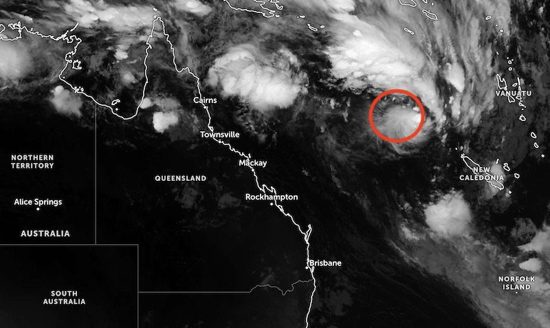
Environmental conditions on San Ho Sea are assessed as favorable for the development of a tropical depression, with low wind shear, sea surface temperature of 27-28 degrees Celsius, and weak but stable high-level wind drainage.
Global forecast models show that the tropical depression may strengthen to reach the tropical storm level (about 65 km/h) in the next 12-24 hours.
The New Zealand Meteorological Agency (MetService) is also monitoring this tropical depression, which is currently located more than 700 km northwest of New Caledonia.
MetService forecasts a new tropical depression - symbol 17U - expected to form in Carpentaria Bay on January 19 (local time), then move north of the San Jose Sea on January 21, 2026.
Tourists who are planning to travel or travel by sea in the San Ho Sea area and neighboring islands need to closely follow the next bulletins from the local meteorological agency.
Meanwhile, Typhoon NOKAEN near the East Sea has weakened again into a tropical depression, according to forecasts from the Philippine Meteorological Agency (PAGASA).
The center of the tropical depression is located about 570 km east of Casiguran, Aurora province of the Philippines, over the sea east of Luzon. The strongest wind near the center reaches 55 km/h, gusting up to 70 km/h.
The tropical depression is moving in a northeast direction at a speed of 15 km/h. The strong wind area caused by the low pressure has a radius of up to 340 km from the center.
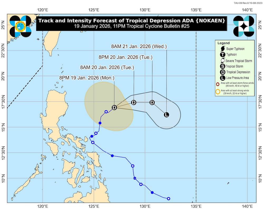
It is forecast that the tropical depression will continue to move in an east-northeast direction on January 20, then gradually shift to the southeast direction on January 21.
Due to the impact of dry air mass from the northeast monsoon, the tropical depression is forecast to gradually weaken and may degrade to a low pressure area on January 21. The storm is unlikely to enter the East Sea.
However, increased cold air will cause strong winds and high-level gusts in many localities, especially coastal and mountainous areas in the Philippines. In the next 24 hours, many coastal areas will have high waves and rough seas.
Tourists planning to travel to the Philippines should proactively take measures to ensure safety for people and property, and regularly update reports of heavy rain, thunderstorms and dangerous weather.


