Low pressure series of storms continuously forming right in January

Chí Long |

Forecast of continuous low pressure, tropical depression and storms in the Indian Ocean and Pacific Ocean in January.

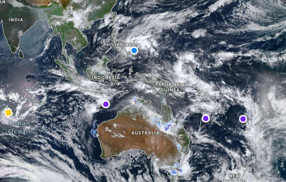
Near the East Sea, the Philippine Atmospheric, Geophysical and Astronomical Services Administration (PAGASA) forecasts that tropical depression Ada will continue to strengthen rapidly.

By 10 am this morning, the center of the tropical depression was located at about 9.6 degrees North latitude - 129.3 degrees East longitude, Surigao city, Surigao del Norte 420 km east.

The strongest wind near the center of the tropical depression reached 55 km/h, gusting up to 70 km/h. The tropical depression is moving in a northwest direction at a speed of 10 km/h.

Ap thap nhiet doi gan Bien Dong sap manh len thanh bao. Anh: PAGASA
Tropical depression near the East Sea is about to strengthen into a storm. Photo: PAGASA

Tropical depression Ada is forecast to strengthen into a storm this afternoon, January 15, causing thunderstorms and strong winds in many areas of the Philippine mainland such as Eastern Samar, Dinagat Islands, Surigao del Norte and Surigao del Sur...

Meanwhile, 2 other low pressure areas are also operating strongly in the Pacific Ocean.

According to the Joint Typhoon Warning Center (JTWC), the low pressure bearing the symbol Invest 94P is located near New Caledonia (France) in the South Pacific region. The strongest wind near the center of the low pressure reaches 30 km/h, gusting up to 35 km/h. The low pressure is unlikely to develop into a tropical depression in the next 24 hours.

Another low pressure bearing the symbol Invest 95P is currently operating near the island nation of Fiji in the South Pacific region. The strongest wind near the center of the low pressure reaches 30 km/h and is also unlikely to develop into a tropical depression in the next 24 hours.

Ap thap va bao xuat hien day dac tren bien An Do Duong va Thai Binh Duong trong thang dau nam. Anh: JTWC
Low pressure and storms appear densely in the Indian Ocean and Pacific Ocean in the first month of the year. Photo: JTWC

In the Indian Ocean, super typhoon Dudzai is showing signs of strengthening again. The strongest wind near the storm center reaches 120 km/h, and is forecast to increase to 130-150 km/h in the next few days.

In addition, a low pressure with the symbol Invest 96S has just appeared in the south of the Nusa Tenggara archipelago, Indonesia. The strongest wind near the center of the low pressure reaches 35 km/h and is forecast to have little chance of developing into a storm in the next 24 hours.

The frequency of quite dense emergence of low pressure and tropical storms at the beginning of the year shows that weather developments in ocean basins pose many risks to maritime activities, offshore fishing and island tourism.

Before this development, tourists who are planning to travel, sightsee or vacation in the Philippines, the South Pacific and Indian Ocean regions need to regularly follow weather forecasts and warnings from local and international authorities.

Tourists should limit going to sea, avoid activities at sea when there is a warning of thunderstorms and strong winds; and proactively adjust their schedules, comply with evacuation instructions and safety recommendations to ensure life and property.

Chí Long
TIN LIÊN QUAN

Typhoon Nokaen officially forms near the East Sea, heavy rain

|

Typhoon Nokaen officially appeared near the East Sea, in the East Sea area of Mindanao (Philippines).

New low pressure area appears, forecasting more storms to form next week

|

A new low pressure offshore the South Pacific, is highly likely to develop into a strong tropical storm off the coast of Australia early next week.

Forecast of when Typhoon Nokaen near the East Sea will officially appear

|

The tropical depression near the East Sea is highly likely to strengthen into a storm within 24 hours.

6 areas affected by tropical depression about to become a storm near the East Sea

|

It is forecast that the tropical depression near the East Sea will strengthen into a storm in the next 24 hours, 6 areas of the Philippines are in the Category 1 storm warning zone.

Tropical depression makes a dashway near the East Sea, heavy rain of 200 mm

|

It is forecast that the tropical depression near the East Sea is going in circles, closely following the mainland area of the Philippines.

Typhoon Nokaen officially forms near the East Sea, heavy rain

Chí Long |

Typhoon Nokaen officially appeared near the East Sea, in the East Sea area of Mindanao (Philippines).

New low pressure area appears, forecasting more storms to form next week

Ninh Phương |

A new low pressure offshore the South Pacific, is highly likely to develop into a strong tropical storm off the coast of Australia early next week.

Forecast of when Typhoon Nokaen near the East Sea will officially appear

Ninh Phương |

The tropical depression near the East Sea is highly likely to strengthen into a storm within 24 hours.

6 areas affected by tropical depression about to become a storm near the East Sea

Chí Long |

It is forecast that the tropical depression near the East Sea will strengthen into a storm in the next 24 hours, 6 areas of the Philippines are in the Category 1 storm warning zone.

Tropical depression makes a dashway near the East Sea, heavy rain of 200 mm

Chí Long |

It is forecast that the tropical depression near the East Sea is going in circles, closely following the mainland area of the Philippines.