Official tropical depression forms near the East Sea, heavy rain

Chí Long |

It is forecast that the low pressure near the East Sea has strengthened into a tropical depression.

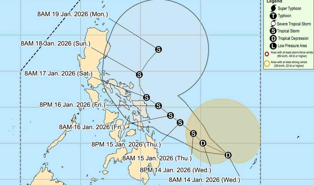
According to the latest weather forecast from the Philippine Atmospheric, Geophysical and Astronomical Services Administration (PAGASA), on the morning of January 14, a low pressure area near the East Sea strengthened into a tropical depression.

By 10 am this morning (local time), the center of the low pressure is located at about 8.2 degrees North latitude - 132.1 degrees East longitude, about 635 km east of Hinatuan. Northeast monsoon affects Northern Luzon.

The strongest wind near the center of the low pressure reached 45 km/h, gusting up to 54 km/h. The low pressure is forecast to be highly likely to strengthen into a tropical depression in the next 24 hours.

Ap thap gan Bien Dong chinh thuc manh len thanh ap thap nhiet doi. Anh: PAGASA
The low pressure area near the East Sea officially strengthens into a tropical depression. Photo: PAGASA

Due to the influence of the tropical depression, the sky is gloomy, scattered thunderstorms begin to appear in some areas such as Visayas East, Davao Region, Caraga, Camiguin, Misamis Oriental, Bukidnon... Moderate to heavy rain may lead to the possibility of floods and landslides.

Weather forecast for tomorrow, January 15, heavy rain of 50-200mm occurs in many places including: Samar, Dinagat Islands, Surigao del Norte, and Surigao del Sur, Catanduanes, Sorsogon, Samar, Biliran, Leyte, Leyte, Dinagat Islands, Surigao del Norte...

In the East Sea, according to the National Center for Hydro-Meteorological Forecasting, on the morning of January 14, at Huyen Tran station, there was strong Northeast wind at level 6, sometimes level 7.

Forecast for the day and night of January 14, the sea area northeast of the Northern East Sea and the sea area west of the Southern East Sea (including the sea area west of the Truong Sa special zone) will have strong Northeast winds at level 6, gusts at level 7-8; rough seas, waves 2.0-3.0m high.

On January 15, the sea area northeast of the Northern East Sea area has strong Northeast winds at level 5, sometimes level 6, gusting at level 7; waves 2.0-3.0m high; rough seas. Level of natural disaster risk at sea: Level 2.

Ships operating in the above areas are at high risk of being affected by strong winds and big waves. People and tourists planning to visit these sea areas should pay attention to weather forecasts and follow local instructions to avoid dangerous storms and floods.

It's a bit of a bit of a bit of a bit of a bit of a bit.

Chí Long
TIN LIÊN QUAN

First super typhoon of 2026 continues to wreak havoc at sea

|

The first strong storm in 2026 - still shedding fierce rain and winds in the Indian Ocean after degrading from super typhoon to typhoon.

Tropical depression makes a dashway near the East Sea, heavy rain of 200 mm

|

It is forecast that the tropical depression near the East Sea is going in circles, closely following the mainland area of the Philippines.

Tropical depression near the East Sea is about to strengthen into a storm heading towards the mainland

|

It is forecast that tropical depression Ada near the East Sea is highly likely to strengthen into a storm in the next 24 hours.

The first impact of the storm is about to appear near the East Sea

|

Tropical depression Ada forming near the East Sea is likely to strengthen into a storm in the next 24 hours.

Official tropical depression forms near the East Sea, heavy rain

|

It is forecast that the low pressure near the East Sea has strengthened into a tropical depression.

Low pressure area near the East Sea likely to become a storm, making landfall

|

The low pressure area near the East Sea is at high risk of strengthening into a tropical depression and developing into the first storm in 2026, warning of heavy rain.

First super typhoon of 2026 continues to wreak havoc at sea

Ninh Phương |

The first strong storm in 2026 - still shedding fierce rain and winds in the Indian Ocean after degrading from super typhoon to typhoon.

Tropical depression makes a dashway near the East Sea, heavy rain of 200 mm

Chí Long |

It is forecast that the tropical depression near the East Sea is going in circles, closely following the mainland area of the Philippines.

Tropical depression near the East Sea is about to strengthen into a storm heading towards the mainland

Chí Long |

It is forecast that tropical depression Ada near the East Sea is highly likely to strengthen into a storm in the next 24 hours.

The first impact of the storm is about to appear near the East Sea

Ninh Phương |

Tropical depression Ada forming near the East Sea is likely to strengthen into a storm in the next 24 hours.

Official tropical depression forms near the East Sea, heavy rain

Chí Long |

It is forecast that the low pressure near the East Sea has strengthened into a tropical depression.

Low pressure area near the East Sea likely to become a storm, making landfall

Ninh Phương |

The low pressure area near the East Sea is at high risk of strengthening into a tropical depression and developing into the first storm in 2026, warning of heavy rain.