According to new weather news from the National Center for Hydro-Meteorological Forecasting, on the evening of September 24, storm No. 9 Ragasa was about 330km east of Mong Cai (Quang Ninh).
The strongest wind is level 12 (118-133km/h), gusting to level 15. The storm continues to move westward, at a speed of about 20km/h.
It is forecasted that by 7:00 a.m. on September 25, the storm will move westward at a speed of about 20km/h and gradually weaken, with the center of the storm at about 21.6°N; 108.9°E, about 100km east of Mong Cai.
The intensity decreased to level 8-9, gusting to level 11. The danger zone is located north of latitude 20.0°N and west of longitude 113.0°E.
The natural disaster risk level is level 3, affecting the northwestern sea area of the North East Sea, the northern Gulf of Tonkin and the northeastern coastal areas.
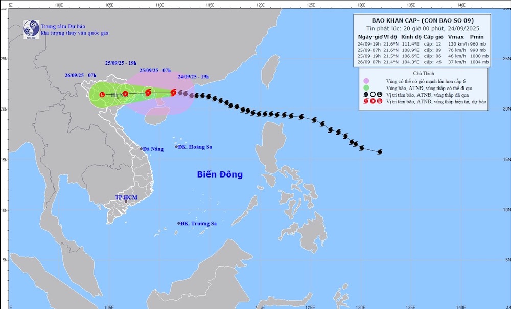
It is forecasted that by 7:00 p.m. on September 25, the storm will continue to move westward at a speed of about 20km/h and gradually weaken into a tropical depression. The center of the low pressure is located at about 21.5°N; 106.6°E, on the mainland of the Northeastern provinces of the North. The intensity is level 6, gust level 8.
The danger zone is located north of latitude 20.0°N and west of longitude 110.0°E. The natural disaster risk level remains at level 3, affecting the Northern Gulf of Tonkin and the Northeast coastal area.
In the northwest sea area of the North East Sea, there will be strong winds of level 8-10, near the center of the storm level 11-12, gusts of level 15, waves 6.0 8.0-00m high, and rough seas.
The North of the Gulf of Tonkin, including Bach Long Vi, Van Don, Co To, Cat Hai and Hon Dau, will have strong winds of level 6-8, waves 2.0-4.0m high; near the storm center, level 9-10, gusts of level 12, waves 3.0-4.0m high, very rough seas.
The coastal waters of Quang Ninh are likely to experience storm surges of 0.3-0.5m high, strongly affecting anchored ships and coastal aquaculture areas.
On land, from early morning on September 25, coastal areas from Quang Ninh to Hung Yen will have winds gradually increasing to level 6-7, near the storm center level 8, gusting to level 9-10. The deep inland areas of the Northeast will have strong winds of level 5, some places will have level 6, gusting to level 7-8.
From the night of September 24 to the end of the night of September 26, the North, Thanh Hoa and Nghe An will have heavy to very heavy rain, with common rainfall of 150-300mm, some places over 450mm, at risk of flooding in urban areas.
In addition, in the afternoon and evening of September 25, the Central and Southern highlands will have scattered showers and thunderstorms with rainfall of 15-30mm, locally heavy rain over 70mm.
From September 25 to 27, floods appeared on rivers in the North, Thanh Hoa and Nghe An. On the Thao River and some small rivers, the flood peak is likely to reach alert level 2-3. On the Lo River, upstream of the Thai Binh, Hoang Long, Buoi rivers and upstream of the Ma River, the flood peak is at alert level 1-2, some rivers are above alert level 2. There is a high risk of flooding, flash floods on small rivers and streams and landslides in mountainous areas.
People and tourists should note that due to the widespread circulation of Typhoon No. 9 Ragasa, they should continue to be on guard against thunderstorms, whirlwinds and strong gusts of wind both before and during the storm's landfall.

Weather forecast for tomorrow, September 25:
Hanoi Lowest temperature: 23-25 degrees Celsius Highest temperature: 27-29 degrees Celsius Cloudy, moderate rain, heavy rain and thunderstorms, locally very heavy rain.
North to northwest wind level 2-3, from early tomorrow morning the wind will gradually increase to level 5.
Northwest Lowest temperature: 22-25 degrees Celsius, some places below 21 degrees Celsius Highest temperature: 27-30 degrees Celsius Cloudy night, scattered showers and thunderstorms; cloudy day, heavy to very heavy rain and thunderstorms.
Light wind.
Northeast Lowest temperature: 23-26 degrees Celsius, mountainous areas below 23 degrees Celsius Highest temperature: 26-29 degrees Celsius Cloudy, moderate rain, heavy rain and scattered thunderstorms at night, locally very heavy rain; heavy to very heavy rain and thunderstorms during the day.
North to northwest wind level 2-3, from early morning coastal areas from Quang Ninh to Hung Yen will have winds gradually increasing to level 6-7, near the storm center level 8-9, gust level2; deep inland areas will have strong winds of level 5, some places level 6, gust level 7-8.
Thanh Hoa to Hue Lowest temperature: 24-27 degrees Celsius Highest temperature: 28-31 degrees Celsius Cloudy, scattered showers and thunderstorms in the North at night, heavy to very heavy rain and thunderstorms during the day; scattered showers and thunderstorms in the South.
North to northwest wind level 2-3.
South Central Coast Lowest temperature: 24-27 degrees Celsius Highest temperature: 31-34 degrees Celsius Cloudy, showers and thunderstorms in some places in the evening and at night, sunny during the day.
West to southwest wind level 2-3.
Central Highlands Lowest temperature: 19-22 degrees Celsius Highest temperature: 27-30 degrees Celsius Cloudy, scattered showers and thunderstorms in some places, scattered showers and thunderstorms in the late afternoon and evening, locally heavy rain in some places.
Southwest wind level 2-3.
Southern region Lowest temperature: 24-27 degrees Celsius Highest temperature: 30-33 degrees Celsius Cloudy, scattered showers and thunderstorms in some places, scattered showers and thunderstorms in the late afternoon and evening, locally heavy rain in some places.
Southwest wind level 2-3.
Ho Chi Minh City Lowest temperature: 24-26 degrees Celsius Highest temperature: 31-33 degrees Celsius Cloudy, scattered showers and thunderstorms in some places, scattered showers and thunderstorms in the late afternoon and evening, locally heavy rain in some places.
Southwest wind level 2-3.


