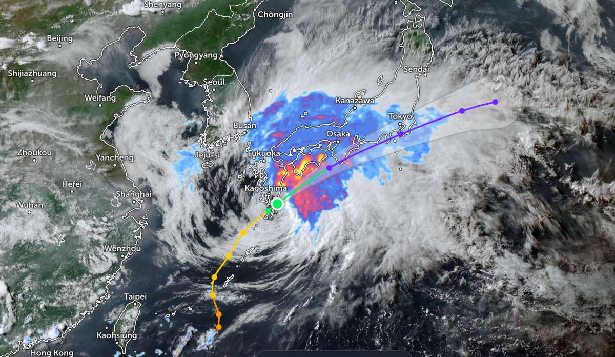
According to Japan Times, as of 11:45 am on June 2, the center of Typhoon Jangmi was located about 140 km southwest of Yakushima Island, Kagoshima Prefecture. The typhoon is moving northeast at a speed of 30 km/h. The sustained wind near the center is up to 25 m/s and gusts are up to 35 m/s.
This morning, Chief Cabinet Secretary Minoru Kihara said that the government had received reports from Kagoshima and Okinawa prefectures about partial damage to six houses, flooded roads, trees and objects knocked down by the storm. Nine people were slightly injured by the storm.
As of 5 am, power outages have affected about 47,930 households in Kagoshima and Okinawa prefectures, and traffic networks have also been disrupted. Two highways including 15 sections have been closed, and one railway line has temporarily stopped operating. Six other operators are expected to temporarily suspend services on 19 other routes later in the day.
A total of 331 flights, mainly to and from the Kyushu area, are expected to be canceled today. Ferry and other maritime services are also affected, with 64 routes operated by 57 companies temporarily suspended in the Kinki, Shikoku, Kyushu and Okinawa areas.
Mr. Kihara said that the government is closely coordinating with local authorities to provide information, collect damage reports and carry out emergency disaster response activities.
He also warned that traffic in the Tokyo metropolitan area could be disrupted from tomorrow morning, June 3.
In areas affected by the storm, we request people to pay attention to the evacuation information issued by local authorities, evacuate early if necessary and always be vigilant while taking measures to protect their lives," he said.
This agency has warned about strong winds, big waves, high tides, landslides, floods in low-lying areas and rising or overflowing river levels in affected areas.
It is expected that the typhoon will gradually shift eastward and move closer to the south of Kyushu today. Tomorrow, according to the Japan Meteorological Society, the typhoon is forecast to move northeast along the southern coast of Honshu and move closer to the Shikoku and Kanto areas, while maintaining strong winds.
In addition, a cold air mass stretching across western Japan is expected to move north along the northeast side of the storm.
Due to strongly developing rain clouds located in the North and East of the storm center, it is expected that there will be widespread heavy rain even before the storm center approaches. Very strong winds can occur even outside the storm center. Several areas may experience torrential rain.
In 24 hours as of 7:20 am this morning, a rainfall station in Amagi town, Kagoshima prefecture recorded heavy rainfall of 209.5 mm, the highest level ever recorded in this area in June.
In the 24 hours up to tomorrow morning, rainfall is forecast to reach 350 mm in Tokai and Kinki regions; 300 mm in the Izu Islands; 250 mm in Shikoku; 200 mm in northern Kyushu and Kanto-Koshin; and 180 mm in southern Kyushu.
As of Thursday morning, rainfall is expected to reach 150 mm in the Kanto region, while the Tohoku region may record 100 mm.
The sea is forecast to become extremely violent, with big waves. Wave height reaches 9 m in the south of Kyushu and the Izu Islands; 8 m in Amami, as well as in the Shikoku, Tokai, Kinki and Kanto regions.
People and tourists planning to visit the sea and islands in southern Japan, where Typhoon Jangmi is sweeping through, should pay attention to weather forecasts. Check flight schedules and consider your itinerary to avoid dangerous storms.


