Typhoon Kalmaegi could strengthen into a super typhoon before making landfall in the next 24 hours

Ninh Phương |

Typhoon Kalmaegi - the predecessor of Typhoon No. 13 - is likely to rapidly intensify, even strengthening into a super typhoon as it approaches the Philippine mainland.

According to the latest storm information from the Philippine Meteorological Agency (PAGASA), typhoon Kalmaegi (local name: Tino) is likely to rapidly strengthen, even strengthening into a super typhoon as it approaches the mainland.

As of this morning, November 3, the center of typhoon Kalmaegi is located 430 km east of Guiuan (Eastern Samar), with the strongest winds of 110 km/h, gusting up to 135 km/h, according to PAGASA's report.

Typhoon Kalmaegi is expected to strengthen into a strong typhoon today, and is likely to approach or make landfall for the first time as it approaches its peak intensity.

PAGASA said that according to different scenarios and climate data, it is impossible to rule out the possibility of Typhoon Kalmaegi reaching super typhoon level.

Weather expert Daniel James Villamil stressed the possibility of rapid intensification as very high, as the sea area in front of the storms path has high water surface temperatures, creating favorable conditions for the storm to strengthen.

Typhoon Kalmaegi is forecast to enter the East Sea from morning to afternoon on Wednesday, November 4 and officially become the 13th storm of the 2025 typhoon season.

Du bao duong di va vung chiu anh huong truc tiep cua bao Kalmaegi sap vao Bien Dong tro thanh bao so 13. Anh: NCHMF
The forecast track and area directly affected by storm Kalmaegi is about to enter the East Sea, becoming storm No. 13. Photo: NCHMF

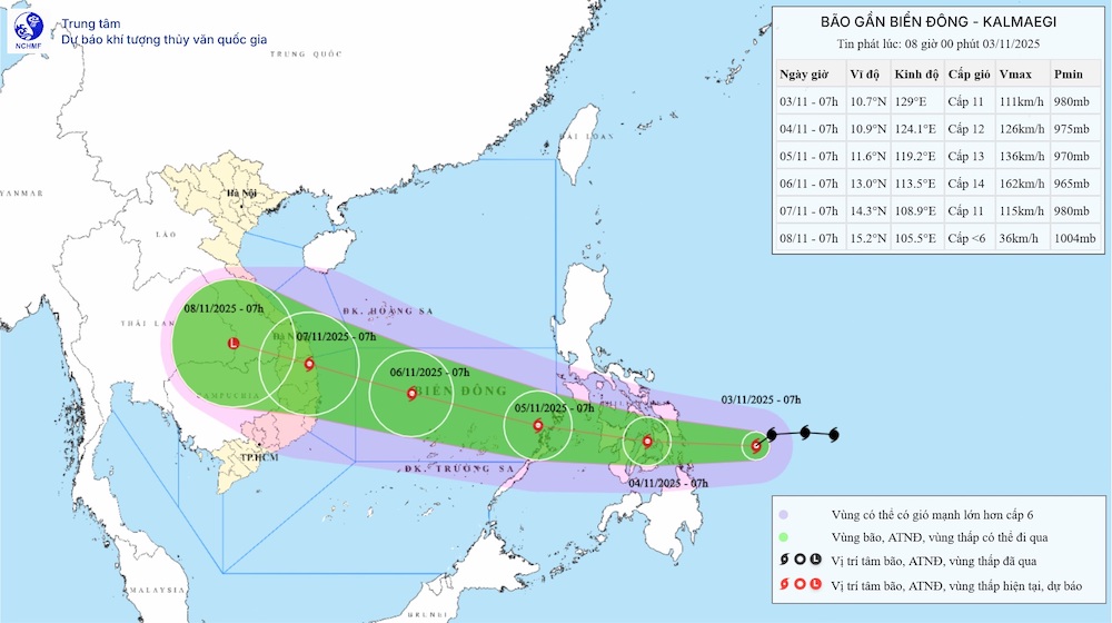
According to the storm news near the East Sea from the National Center for Hydro-Meteorological Forecasting, around the morning of November 5, storm Kalmaegi will officially move into the East Sea, affecting the eastern sea area of the Central East Sea.

From around the afternoon of November 4, the sea area east of the Central East Sea will have winds gradually increasing to level 6-7, then increasing to level 8-9; the area near the storm center will be strong at level 10-12, gusting to level 14-15, waves 5.0-4.0m high. The sea is rough.

During the period from November 5 to 6, the Central East Sea area (including Truong Sa special zone), the sea off the Da Nang - Khanh Hoa area is likely to be affected by strong winds of level 12-14, gusting above level 17, waves 8.0-10.0m high. The sea is rough.

Tourists in the Philippines - especially in the Philippines, Philippines, and Palawan; the sea and islands from Da Nang to Khanh Hoa need to continuously update weather warnings.

The operation of boats, ferries, and aircraft may be interrupted.

Proactively adjust your outdoor schedule, especially at coastal or island tourist destinations.

Ninh Phương
TIN LIÊN QUAN

Cold and rainy weather in Hanoi lasts until the end of the week before welcoming the warm sun

|

Hanoi weather forecast for the next 7 days is the coldest at about 17 degrees Celsius with humid rain, locally heavy rain, due to the influence of the strengthening cold air.

Weather forecast for today, November 3: Storm Kalmaegi increases in intensity when entering the East Sea

|

Weather forecast for today, November 3, cold air continues to cause rain in the North and Central regions. Typhoon Kalmaegi rapidly intensified before entering the South China Sea as Typhoon No. 13.

Typhoon Kalmaegi accelerates to make landfall, enters the East Sea as a strong storm No. 13

|

Typhoon Kalmaegi is likely to reach its peak intensity, with winds of up to about 195 km/h when it enters the East Sea.

Storm No. 13 could enter the East Sea next week

|

The low pressure off the Philippines has strengthened into a tropical depression, continuing to develop into the first storm to enter the East Sea in early November.

Cold and rainy weather in Hanoi lasts until the end of the week before welcoming the warm sun

Ninh Phương |

Hanoi weather forecast for the next 7 days is the coldest at about 17 degrees Celsius with humid rain, locally heavy rain, due to the influence of the strengthening cold air.

Weather forecast for today, November 3: Storm Kalmaegi increases in intensity when entering the East Sea

Lam Hải |

Weather forecast for today, November 3, cold air continues to cause rain in the North and Central regions. Typhoon Kalmaegi rapidly intensified before entering the South China Sea as Typhoon No. 13.

Typhoon Kalmaegi accelerates to make landfall, enters the East Sea as a strong storm No. 13

Ninh Phương |

Typhoon Kalmaegi is likely to reach its peak intensity, with winds of up to about 195 km/h when it enters the East Sea.

Storm No. 13 could enter the East Sea next week

Ninh Phương |

The low pressure off the Philippines has strengthened into a tropical depression, continuing to develop into the first storm to enter the East Sea in early November.