New low pressure is expected to appear in November

Ninh Phương |

The new low pressure may strengthen into a tropical depression. The possibility of a strong storm or super typhoon near the East Sea is forecast in early November.

According to the new low pressure forecast from the Joint Typhoon Warning Center (JTWC), two low pressure areas operating in the western Pacific are likely to develop into tropical depressions in the next few days.

Low pressure

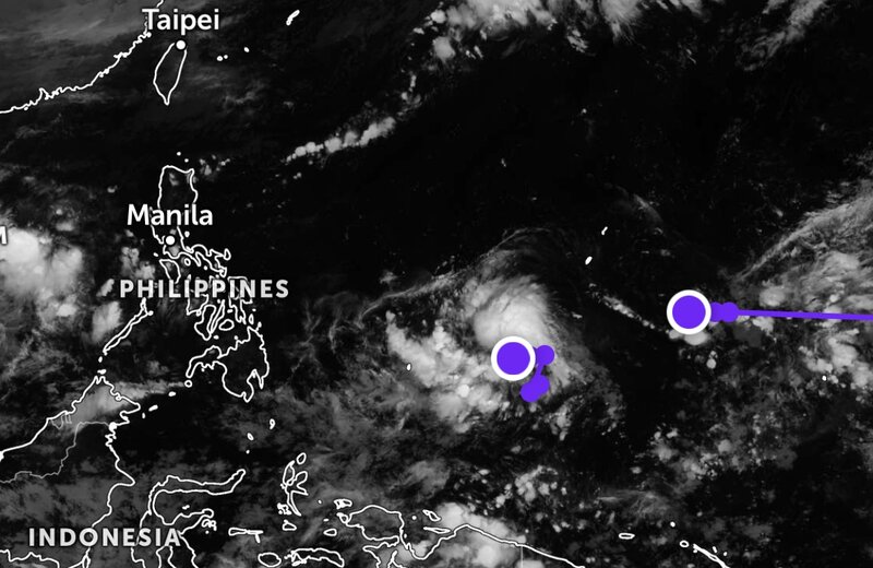
A low pressure is currently located near Yap (Micronesia) and has a moderate chance of strengthening into a tropical depression in the next 24 hours. The wind will remain strong at about 25-35 km/h, and the environmental conditions will be quite favorable for development in the next 1-2 days.

The Philippine Atmospheric and Geophysical Agency (PAGASA) is also monitoring the low pressure.

The low pressure is located about 1,560 km east of Northeast Mindanao. PAGASA assessed the possibility of tropical depression formation at a high level.

It is likely that tomorrow evening or Sunday, the system will strengthen and become a tropical depression.

The low pressure is forecast to enter PAR on Sunday, November 2 or Monday, November 3 as a tropical depression or tropical storm.

Another low pressure is located in the western Pacific, with a low chance of developing into a tropical depression in the next 24 hours. The strongest wind near the center of the depression is about 25-35 km/h.

Forecast models show that this low pressure is likely to continue moving westward and may gradually strengthen over the next few days.

Hai vung ap thap lien tiep xuat hien gan Bien Dong. Anh: JWTC
Two consecutive low pressure areas appear near the East Sea. Photo: JWTC

Risk of storm formation, even super typhoon appearance

According to PAGASA's weather bulletin, the forecast model shows that next week, a new low pressure area may appear, moving west-north towards Palawan, then out of the Philippine monitoring area (PAR). This is a cloud system being observed in the Palawan and Mindoro regions.

In addition, the low pressure area off the Philippines is likely to gradually strengthen as it moves across the Philippine Sea. Initial forecasts show that by Sunday, the system could enter the Philippine Area of Responsibility and develop into a typhoon.

The possibility of this low pressure strengthening into a super typhoon before affecting the Philippine mainland cannot be ruled out.

However, due to the forecast time being far away, the trajectory and intensity may change, it is necessary to monitor further PAGASA bulletins.

Behind the system, the meteorological model also shows another low pressure area likely to form and move west-northwest, towards Northern Luzon next week. The paths of both systems are still uncertain.

The storm is expected to be Tino and next to Ferbena.

Recommendations for tourists

Tourists planning to travel by sea, fly through the Philippines, Taiwan (China)... or travel to coastal destinations this week and next week should:

Follow updates from official forecasters. Limit belief in unverified information spread on social networks about "super storms" or strong storms.

Check the weather before booking flights, island tours, sea tours; some trains or outdoor activities may be adjusted when the weather is bad.

Proactively contact airlines, hotels or travel companies to have a plan to change your schedule if there are new recommendations.

Ninh Phương
TIN LIÊN QUAN

Low pressure developments in the East Sea cause widespread heavy rain

|

The low pressure in the East Sea is causing severe thunderstorms, rough seas, and high waves.

Storm No. 13 could enter the East Sea next week

|

The low pressure off the Philippines has strengthened into a tropical depression, continuing to develop into the first storm to enter the East Sea in early November.

Low pressure connects to low pressure continuously appears, likely to strengthen in the next 24 hours

|

A new low pressure system is expected to form one after another, with one system likely to strengthen into a tropical depression heading towards the East Sea.

Weather forecast for tomorrow, November 1: Monsoon overflows to the Central region, cold rain covers

|

Weather forecast for tomorrow, November 1, cold air continues to strengthen, the North, Thanh Hoa and North Nghe An will have rain in many places.

Central region is about to welcome a new flood, warning of deep flooding

|

The forecast of prolonged heavy rain causing the water level of Thu Bon River to exceed alert level 3, many areas in the Central region continue to face the risk of flooding.

Hue to welcome 2 more prolonged heavy rains after record floods

|

Hue weather continues to have rain due to the influence of cold air. The total rainfall from October 30 to November 8 is forecast to be 600-900mm, with some places over 1,000mm.

Low pressure developments in the East Sea cause widespread heavy rain

Ninh Phương |

The low pressure in the East Sea is causing severe thunderstorms, rough seas, and high waves.

Storm No. 13 could enter the East Sea next week

Ninh Phương |

The low pressure off the Philippines has strengthened into a tropical depression, continuing to develop into the first storm to enter the East Sea in early November.

Low pressure connects to low pressure continuously appears, likely to strengthen in the next 24 hours

Ninh Phương |

A new low pressure system is expected to form one after another, with one system likely to strengthen into a tropical depression heading towards the East Sea.

Weather forecast for tomorrow, November 1: Monsoon overflows to the Central region, cold rain covers

Ninh Phương |

Weather forecast for tomorrow, November 1, cold air continues to strengthen, the North, Thanh Hoa and North Nghe An will have rain in many places.

Central region is about to welcome a new flood, warning of deep flooding

NGUYỄN ĐẠT |

The forecast of prolonged heavy rain causing the water level of Thu Bon River to exceed alert level 3, many areas in the Central region continue to face the risk of flooding.

Hue to welcome 2 more prolonged heavy rains after record floods

Hồ Thu |

Hue weather continues to have rain due to the influence of cold air. The total rainfall from October 30 to November 8 is forecast to be 600-900mm, with some places over 1,000mm.