Typhoon Luana hits the mainland, pouring heavy rain

Chí Long |

Typhoon Luana is forecast to strengthen fiercely when it makes landfall.

According to the Joint Typhoon Warning Center (JTWC), Typhoon Luana has strengthened fiercely as it makes landfall in Australia, becoming a Category 2 tropical storm.

On the evening of January 24, the center of the storm was about 100 km northeast of Broome city (Australia). The strongest wind near the center of the storm reached 95 km/h. The storm moved in a Southeast direction at a speed of about 11 km/h.

Cap nhat huong di cua bao Luana. Anh: JTWC
Update on the direction of Typhoon Luana. Photo: JTWC

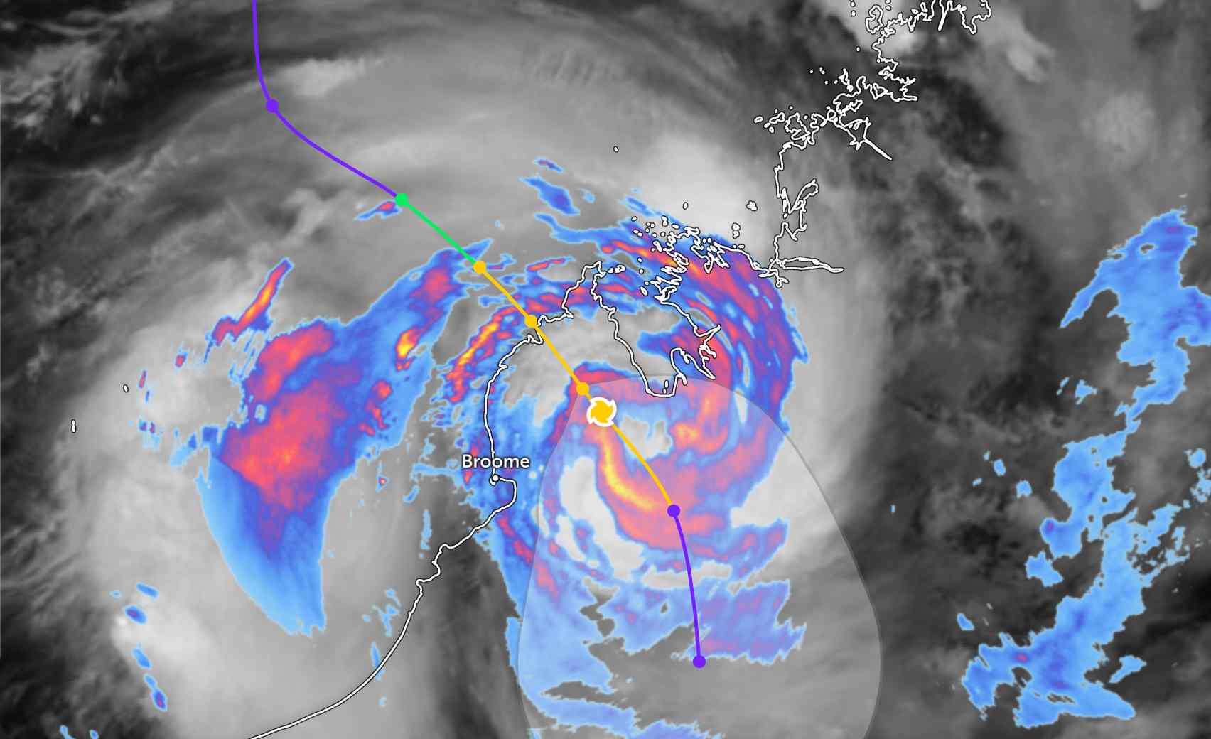
JTWC forecasts that Typhoon Luana will continue to move deep into the mainland of the Kimberley area, Western Australia. In the next 12 hours, Typhoon Luana will continue to move in a Southeast direction, then gradually move south as a high pressure area forms in the central area of Australia and dominates the direction of the typhoon.

Due to the impact of the terrain, the storm's circulation is forecast to weaken rapidly, decreasing below the intensity of a tropical depression in the next 24 hours.

Meteorologist Jonathan How of the Australian Meteorological Agency (BoM) said Typhoon Luana will bring dangerous weather to people and tourists in the coastal areas of Kimberley and Northern Australia throughout the weekend holiday.

He said: "Strong winds can reach speeds of up to 120 km/h in the southern areas of the alert zone, including Broome.

Heavy rain causing flash floods may also occur, causing roads to be flooded. Rainfall is expected to reach 100-200 mm.

The storm is expected to move south, bringing heavy rain into the mainland of Western Australia early next week.

People and tourists who plan to go to places where the storm passes should pay attention to weather forecasts. Follow local instructions to avoid dangerous storms and rain throughout the journey.

Chí Long
TIN LIÊN QUAN

New cold air wave is about to arrive, the North is cold again

|

A new cold air wave at the end of January will flood into the North, causing the temperature to drop again, with gloomy weather.

Weather forecast today 25.1: Northern region cold rain, lowest below 7 degrees C

|

Weather forecast today 25.1, Northern and North Central regions have cold rain, Southern region sunny.

Vietnamese tourists hunt for rare red auroras amidst the strongest solar storm in 20 years

|

Vietnamese tourists have had unforgettable memories when witnessing the brilliant night sky in Europe with rare red aurora borealis.

Tropical depression officially becomes a storm approaching the mainland

|

Tropical depression 16P officially strengthens into a tropical storm in the southern Pacific Ocean.

Typhoon Dudzai makes a detour, new low pressure appears

|

Typhoon Dudzai has strengthened again over the southwestern Indian Ocean, while a tropical depression is operating near Mozambique.

New cold air wave is about to arrive, the North is cold again

Dương Đông |

A new cold air wave at the end of January will flood into the North, causing the temperature to drop again, with gloomy weather.

Weather forecast today 25.1: Northern region cold rain, lowest below 7 degrees C

Chí Long |

Weather forecast today 25.1, Northern and North Central regions have cold rain, Southern region sunny.

Vietnamese tourists hunt for rare red auroras amidst the strongest solar storm in 20 years

Ninh Phương |

Vietnamese tourists have had unforgettable memories when witnessing the brilliant night sky in Europe with rare red aurora borealis.

Tropical depression officially becomes a storm approaching the mainland

Dương Đông |

Tropical depression 16P officially strengthens into a tropical storm in the southern Pacific Ocean.

Typhoon Dudzai makes a detour, new low pressure appears

Ninh Phương |

Typhoon Dudzai has strengthened again over the southwestern Indian Ocean, while a tropical depression is operating near Mozambique.