Tropical Storm 16P is currently located about 352 km northwest of Noumea (New Caledonia, French overseas territory), moving southeast at a fairly fast speed of more than 45 km/h in the past 6 hours.
The maximum wave height reaches about 4.9 m, showing dangerous sea conditions for tourism and maritime activities.
Accuweather recorded the strongest wind near the storm center reaching 75 km/h, gusting at 95 km/h.
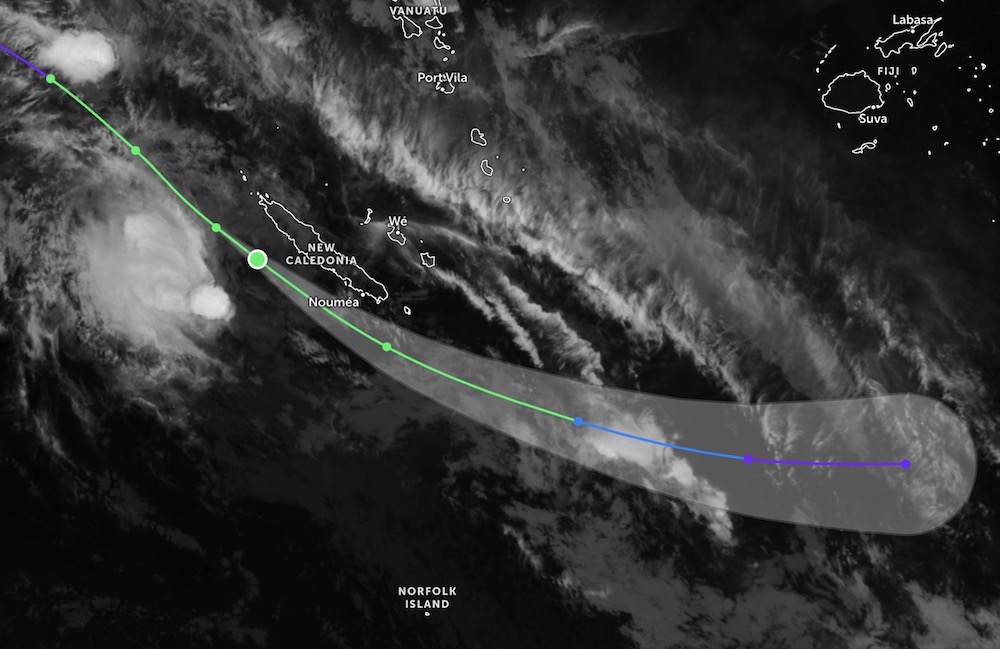
According to the latest storm news from the US Joint Typhoon Warning Center (JTWC), forecast for the next 24 hours, tropical storm 16P is forecast to continue to move southeast, following the southwest edge of the subtropical high pressure.
Current forecast models show that the storm's center is likely to deviate southward to New Caledonia, but just a slight deviation in orbit could lead to the possibility of a direct landfall in this area.
After the 24-hour mark, the storm is forecast to gradually move eastward.
Tropical Storm 16P is forecast to maintain its current intensity in the next 12 hours, due to unchanged environmental conditions. However, if the system interacts more with the terrain of New Caledonia, a rapid weakening possibility is a possible scenario.
Strong winds are forecast to sweep through the southern coastal area of New Caledonia, in which the vicinity of Noumea may be directly affected as the storm's eye passes through.
Tourists planning to travel to New Caledonia or travel by sea in the Southwest Pacific region should regularly update tropical depression or storm bulletins, limit outdoor activities, especially sea tourism, diving, yachts, until the weather situation stabilizes again.
Meanwhile, Typhoon NOKAEN near the East Sea has weakened into a low pressure, no longer capable of strengthening again.
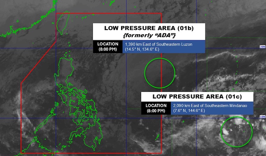
Another low pressure area operating outside the Philippine responsibility zone LPA 01c is being monitored and is forecast to be unlikely to rise in the next 24 hours.
Weather forecast at sea in Vietnam, the Northern East Sea area (including Hoang Sa special zone) strong Northeast wind level 6-7, gusts level 8-9, sea waves 4.0-6.0m high, strong sea waves.
In the Gulf of Tonkin, the Northeast wind is strong at level 6, gusting at level 7-8, waves 2.0-3.0m high, rough seas.
The area from South Quang Tri to Khanh Hoa and the Central East Sea area will gradually strengthen the Northeast wind to level 6, gusting to level 7-8, waves 2.0-5.0m high, rough seas.
The sea area from Lam Dong to Ca Mau, the western sea area of the South East Sea (including the western sea area of Truong Sa special zone) will gradually strengthen to level 6, sometimes level 7, gusts level 8-9, waves 3.0-5.0m high, strong sea waves.
Localized heavy rain, strong winds and big waves at sea are likely to affect socio-economic activities and boats. People and tourists need to comply with the recommendations of functional agencies if they plan to travel by sea.


