According to the latest storm news from the Philippine Atmospheric, Geophysical and Astronomical Services Administration (PAGASA), Typhoon Nokaen has approached the mainland Philippines.
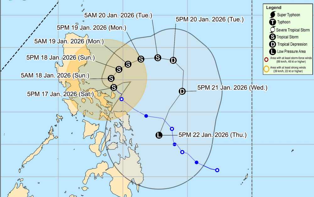
As of 7 pm tonight (local time), the storm's center is located at about 14.5 degrees North latitude - 124.2 degrees East longitude, over the waters along the coast of Pandan, Catanduanes.
The strongest wind near the storm center reaches 85 km/h, gusting at 105 km/h. The storm moves in a Northwest direction at a speed of about 15 km/h. The wind radius from the storm center stretches up to 440 km.
Areas with strong winds that pose a small threat to life and property include the East of Camarines Norte (Vinzons, San Lorenzo Ruiz, San Vicente, Talisay, Basud, Mercedes, Daet, Paracale), the East and center of Camarines Sur (Siruma, Tinambac, Ocampo, Goa, Lagonoy, Milaor, Nabua, Buhi, Caramoan, Baao, Cabusao, Bato, Camaligan, Pili, Sipocot, Tigaon, Pamplona, Garchitorena, City of Iriga, San Fernando, Magarao, Minalabac, Balatan, Libmanan, City of Naga, Calabanga, Bombon, Bula, Canaman, Pasacao, Sag nay, San Jose, Presentacion, Gainza, Lupi), Albay and Catanduanes.
Heavy rain of 100-200 mm appeared in the Catanduanes and Camarines Sur areas. Other areas including Quezon, Camarines Norte, Albay, Sorsogon and Northern Samar have forecast rainfall of about 50-100 mm.
Heavy rain leads to the possibility of flooding, especially in urbanized areas, low-lying areas or riverside areas. The risk of landslides is high in areas easily affected from medium to high.
Typhoon Nokaen is forecast to move to the Northwest today before slowly shifting to the North to the Northeast on January 18. From tomorrow onwards, it is forecast that the typhoon will follow a ring road on the sea east of Luzon.
It is forecast that Nokaen will still maintain the intensity of a tropical storm when moving through the sea east of Luzon. It is possible that the storm will strengthen fiercely in the near future.
In the East Sea, according to the National Center for Hydro-Meteorological Forecasting, on the night of January 17 and January 18, the sea area east of the Northern East Sea area had strong Northeast winds at level 6, sometimes level 7, gusting at level 8-9; strong sea waves, waves 2.0 to 4.0m high.
Forecast for the night of January 18 and day of January 19, the sea area east of the Northern East Sea area will continue to have strong Northeast winds at level 6, sometimes level 7, gusting at level 8-9; strong sea waves, waves 2.0 to 4.0m high.
Faced with the complicated developments of Typhoon Nokaen, functional agencies recommend that people in affected areas should proactively closely monitor weather forecasts and warnings; limit going out when unnecessary, especially in riverside areas, low-lying areas, and areas at risk of landslides.
For tourists, it is necessary to consider adjusting their itinerary, avoiding moving to areas with heavy rain, strong winds or rough seas. All ships and vehicles operating at sea are advised not to go out to sea during this time, and at the same time quickly find safe shelters to limit damage caused by strong winds and big waves.


