According to the latest storm news from the Philippine Atmospheric, Geophysical and Astronomical Services Administration (PAGASA), Typhoon Nokaen continues to operate strongly near the East Sea.
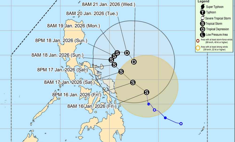
As of 10 am this morning, the storm's center was located at about 11.5 degrees North latitude - 128.7 degrees East longitude, 325 km east of Guiuan, Eastern Samar.
The strongest wind near the storm center reaches 65 km/h, gusting at 80 km/h. The storm moves in a Northwest direction at a speed of about 15 km/h.
Due to the impact of the storm, areas with heavy rain of 100-200 mm in the next 24 hours are forecast to include North Samar and East Samar. The areas of Catanduanes, Albay, Sorsogon, Samar, Biliran, Leyte, South Leyte, and the Dinagat Islands have rain from 50-100 mm.
Forecast for the next 24 to 48 hours (January 17-18), areas with rain of 100-200 mm include Catanduanes, Albay, and Sorsogon. Rainfall of 50-100 mm in Camarines Norte, Camarines Sur, Masbate, North Samar, East Samar, Samar, Biliran, and Leyte
Forecast rainfall may be higher in mountainous and highland areas. Heavy rain may cause significantly worse weather.
PAGASA emphasized that heavy rain and strong winds may still occur in localities outside the landing point and forecast.
Typhoon Koraen will move normally to the Northwest from today to tomorrow (January 17) before slowly shifting from the Northwest to the Northeast on Sunday (January 18). Starting on Tuesday evening (January 20), the typhoon is forecast to move southeast as it passes through the sea east of the Bicol Region.
The storm's center may move closer to Eastern Samar and Northern Samar tomorrow and Catanduanes from tomorrow evening to Sunday. If it deviates further west, the storm is likely to make landfall in eastern Visayas and the Bicol region of the Philippines.
Tourists who plan to travel by air or sea through the storm-affected area should pay attention to weather forecasts. Avoid going out to sea when the sea is rough and follow local instructions to ensure safety.


