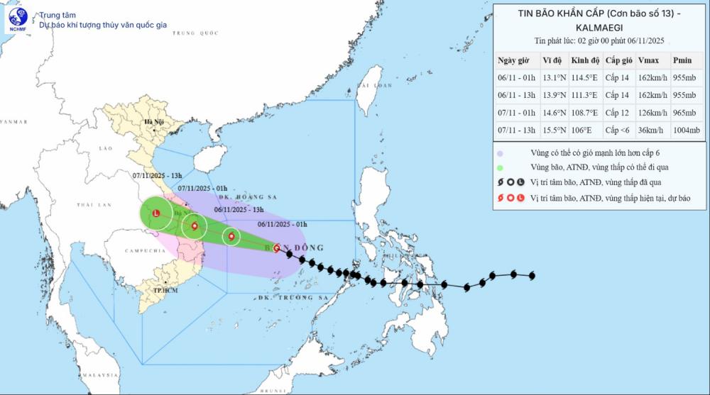
According to the latest storm information from the National Center for Hydro-Meteorological Forecasting, at 8:00 a.m. this morning (November 6), the center of storm Kalmaegi was at about 13.1 degrees North latitude; 112.0 degrees East longitude, about 310km East Southeast of Quy Nhon (Gia Lai).
The strongest wind near the storm center is level 14 (150-166km/h), gusting to level 17 (202-220km/h) - super typhoon level. It is forecasted that in the next 3 hours, the storm will move mainly in a westerly direction, at a speed of about 25km/h.
As of 7:00 p.m. today, the center of the storm was at about 14.0 degrees North latitude - 109.4 degrees East longitude, in the coastal area of Quang Ngai - Dak Lak. The strongest wind near the storm center is level 14, gusting to level 17.
The storm is moving west-northwest at a speed of 25-30km/h. Natural disaster risk level: Level 4 for the West of the Central East Sea, the sea area from Quang Ngai to Dak Lak (including Ly Son special zone); the mainland east of the area from Quang Ngai to Gia Lai; Level 3 for the sea area from South Quang Tri to Da Nang city (including Cu Lao Cham island) and Khanh Hoa; mainland from South Quang Tri to Da Nang city, the East of Dak Lak province and the North of Khanh Hoa province.
At 7:00 a.m. on November 7, the center of the storm was at about 15.0 degrees North latitude - 107.0 degrees East longitude, in the Southern Laos area. The storm is moving west-northwest at a speed of about 25km/h, making landfall and gradually weakening into a tropical depression.
The strongest wind near the storm center is level 7, gusting to level 9. Natural disaster risk level: level 4 for the sea area from Quang Ngai to Dak Lak (including Ly Son special zone); mainland east of Quang Ngai to Gia Lai; Level 3 for the sea area from South Quang Tri to Da Nang city (including Cu Lao Cham island) and Khanh Hoa; mainland South Quang Tri to Da Nang city, the west of Quang Ngai and Gia Lai provinces, the east of Dak Lak province and the north of Khanh Hoa province.
Due to the influence of the storm, the Central East Sea area has strong winds of level 8-11; the area near the storm center has strong winds of level 12-14, gusts of level 17, waves 5.0-4.0m high, the area near the storm center has 8.0-10.0m high; the sea is very rough.
The sea area from South Quang Tri to Khanh Hoa (including Ly Son special area, Cu Lao Cham island) will have winds gradually increasing to level 6-7, then increasing to level 8-11, waves 3.0-6.0m high; the area near the storm's eye will have strong winds of level 12-14, gusts of level 17, waves 7.0 9.0m high; the sea will be very rough.
Coastal areas from South Quang Tri to Dak Lak will have storm surge of 0.4-0.8m high.
From the afternoon of November 6, coastal areas from Hue City to Dak Lak should be on guard against rising sea levels accompanied by large waves causing flooding in low-lying areas, waves of dike overflow, coastal roads, and coastal erosion, slowing flood drainage in the area. All ships, boats, and aquaculture areas in the above-mentioned dangerous areas are strongly affected by thunderstorms, whirlwinds, strong winds, large waves, and rising sea levels.
From the afternoon of November 6, on land from the South of Da Nang City to Dak Lak, the wind will gradually increase to level 6-7, then increase to level 8-9, the area near the storm's eye will have strong winds of level 10-12 (focusing on the East of Quang Ngai - Gia Lai provinces), gusting to level 14-15.
The area from South Quang Tri to the North of Da Nang City and the North of Khanh Hoa Province will have strong winds of level 6-7, gusting to level 8-9. The strongest wind will be from the evening to the night of November 6.
From the evening and night of November 6, the western provinces from Quang Ngai to Gia Lai will have winds gradually increasing to level 6-7, near the storm's eye will have strong winds of level 8-9, gusting to level 11.
From November 6-7, the area from Da Nang City to Dak Lak will have very heavy rain with common rainfall of 200-400mm/ods, locally over 600mm/ods; the area from South Quang Tri to Hue City, Khanh Hoa and Lam Dong will have heavy rain with common rainfall of 150-300mm/ods, locally very heavy rain over 450mm/ods. From November 8, heavy rain in the above areas tends to decrease.
From November 7-8, the North of Quang Tri to Thanh Hoa will have moderate rain, heavy rain with common rainfall of 50-150mm/ods, locally very heavy rain over 200mm/ods. Warning of the risk of heavy rain (>200mm/3 hours)
Due to the influence of a wide storm circulation, it is necessary to be on guard against the risk of thunderstorms, tornadoes and strong gusts of wind both before and during the storm's landfall.
People and tourists in these areas should pay attention to weather forecasts. Avoid going out when the weather turns bad and follow local instructions to prevent dangerous storms.


