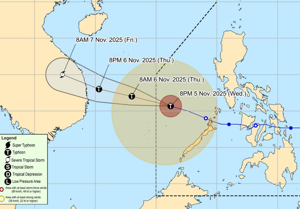
According to the latest weather forecast from the National Center for Hydro-Meteorological Forecasting, today, November 6, storm No. 13 Kalmaegi will approach the mainland of Central Vietnam.
It is forecasted that by 7:00 p.m. on November 6, the center of the storm will be at about 13.7 meters of Vi Bac - 110.3 degrees East longitude, about 120km East Southeast of Quy Nhon (Gia Lai). The storm is moving west-northwest at a speed of about 25km/h.
The strongest wind near the storm center is level 14, gusting to level 17. Natural disaster risk level: level 4 for the Central East Sea area (including the sea area north of Truong Sa special zone), the sea area off the coast from Quang Ngai to Dak Lak (including Ly Son special zone); the mainland east of Quang Ngai to Dak Lak; Level 3 for the sea area from South Quang Tri to Da Nang city (including Cu Lao Cham island) and Khanh Hoa; the mainland from South Quang Tri to Da Nang city and the northern area of Khanh Hoa province.
The storm will move inland Vietnam tonight and early tomorrow morning, November 7.
Due to the influence of storm No. 13, the Central East Sea area (including the northern sea area of Truong Sa special zone) has strong winds of level 8-19. The area near the storm's eye will have strong winds of level 12-14, gusts of level 17, waves 5.0-7.0m high, the area near the storm's eye will have a height of 8.0-10.0m; the sea will be very rough.
From early this morning, the sea area from South Quang Tri to Khanh Hoa (including Ly Son special area, Cu Lao Cham island) will have winds gradually increasing to level 6-7, then increasing to level 8-11, waves 3.0-5.0m high; the area near the storm's eye will have strong winds of level 12-14, gusts of level 17, waves 6.08,0m high; the sea will be very rough.
From this evening, coastal areas from Hue City to Dak Lak should be on guard against rising sea levels accompanied by large waves causing flooding in low-lying areas, waves of dike overflow, coastal roads, and coastal erosion, slowing flood drainage in the area.
All ships, boats, and aquaculture areas in the above-mentioned dangerous areas are strongly affected by thunderstorms, whirlwinds, strong winds, large waves, and rising sea levels.
On the mainland along the coast from South Quang Tri to Da Nang City, the East of the provinces from Quang Ngai to Dak Lak, the wind will gradually increase to level 6-7, then increase to level 8-9, the area near the storm's eye will be strong at level 10-12 (focusing on the East of Quang Ngai - Dak Lak provinces), gusting to level 14-15.
From tonight and tonight, the West of the provinces from Quang Ngai to Dak Lak, the northern area of Khanh Hoa province will gradually increase the wind to level 6-7, the area near the storm's eye will have strong winds of level 8-9, gusting to level 11.
Today and tomorrow, the area from Da Nang City to Dak Lak will have very heavy rain with common rainfall of 200-400mm/ods, locally over 600mm/ods; the area from South Quang Tri to Hue City, Khanh Hoa and Lam Dong will have heavy rain with common rainfall of 150-300mm/ods, locally very heavy rain over 450mm/ods.
From November 8, heavy rain in the above areas tends to decrease.
People and tourists in provinces and cities directly affected by storm No. 13 Kalmaegi should pay attention to weather forecasts, find safe shelters, raise furniture, prepare food reserves and emergency communication measures.
Avoid going out when the weather turns bad, absolutely do not go to sea and follow local instructions to ensure safety.
Weather forecast for today, November 6, nationwide:
City. Hanoi
Lowest temperature: 19-21 degrees Celsius.
Highest temperature: 25-27 degrees Celsius.
Cloudy, no rain, sunny in the afternoon.North to northeast wind level 2-3.Cold at night and early morning.
Northwest
Lowest temperature: 17-20 degrees Celsius, some places below 16 degrees Celsius.
Highest temperature: 24-27 degrees Celsius, some places above 27 degrees Celsius.
Cloudy, some rain, sunny in the afternoon.Light wind.Cold at night and early morning.
Northeast
Lowest temperature: 17-20 degrees Celsius, mountainous areas below 16 degrees Celsius.
Highest temperature: 24-27 degrees Celsius, some places above 27 degrees Celsius.
Cloudy, some rain, sunny in the afternoon.North to northeast wind level 2-3.Cold at night and early morning.
Thanh Hoa to Hue
Lowest temperature: 19-22 degrees Celsius.
Highest temperature: 24-27 degrees Celsius.
Cloudy, some rain in the North; South has scattered showers and thunderstorms, some places have heavy rain, from tomorrow afternoon there will be heavy to very heavy rain.North to northwest wind level 2-3; in the South tomorrow afternoon, the wind will gradually increase to level 6-7.Cold at night and morning.During thunderstorms, there is a possibility of tornadoes, lightning and strong gusts of wind.
South Central Coast
Lowest temperature: 22-25 degrees Celsius.
Highest temperature: North 24-26 degrees Celsius; South 27-29 degrees Celsius.
Cloudy, scattered showers and thunderstorms, locally heavy rain; from tomorrow afternoon there will be heavy to very heavy rain.Northwest wind level 2-4, tomorrow evening gradually increase to level 6-7.During thunderstorms, there is a possibility of tornadoes, lightning and strong gusts of wind.
Central Highlands
Lowest temperature: 20-23 degrees Celsius.
Highest temperature: 23-26 degrees Celsius.
Cloudy, scattered showers and thunderstorms, locally heavy rain; from tomorrow afternoon there will be heavy to very heavy rain.Northwest wind level 2-4.During thunderstorms, there is a possibility of tornadoes, lightning and strong gusts of wind.
Southern region
Lowest temperature: 23-26 degrees Celsius.
Highest temperature: 29-32 degrees Celsius.
Cloudy, scattered showers and thunderstorms; in the afternoon and evening, there will be scattered showers and thunderstorms, locally heavy rain.Light wind.During thunderstorms, there is a possibility of tornadoes, lightning and strong gusts of wind.
Ho Chi Minh City
Lowest temperature: 23-25 degrees Celsius.
Highest temperature: 30-32 degrees Celsius.
Cloudy, scattered showers and thunderstorms; in the afternoon and evening, there will be scattered showers and thunderstorms, locally heavy rain.Light wind.During thunderstorms, there is a possibility of tornadoes, lightning and strong gusts of wind.


