According to the latest storm news from the National Center for Hydro-Meteorological Forecasting, early this morning, November 5, storm Kalmaegi entered the eastern sea area of the Central East Sea, the 13th storm in the East Sea in 2025.
At 8:00 a.m. this morning, the center of the storm was at about 11.4 degrees North latitude - 118.7 degrees East longitude, about 480km east of Song Tu Tay Island. The strongest wind near the storm center is level 13 (134-149km/h), gusting to level 16.
It is forecasted that in the next 3 hours, the storm will move in a West-Northwest direction, at a speed of about 20-25km/h.
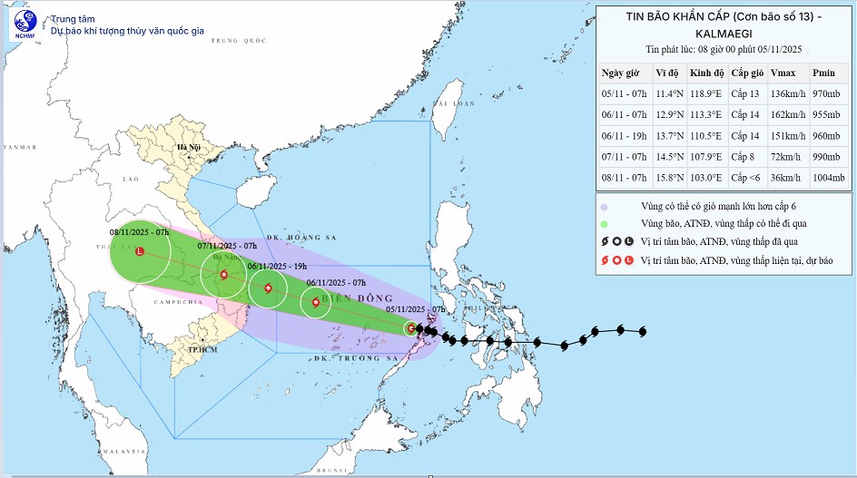
At 7:00 a.m. on November 6, the center of storm No. 7 was at about 12.9 degrees North latitude - 113.3 degrees East longitude, about 480 km East Southeast of the Gia Lai province coast. The storm is moving west-northwest at a speed of about 25 km/h, likely to strengthen.
The strongest wind near the storm center is level 14, gusting to level 17. Natural disaster risk level: level 4 for the central East Sea area, including the sea area north of Truong Sa special zone.
At 7:00 p.m. on November 6, the storm continued to move in a West-Northwest direction at a speed of about 25 km/h, approaching the shore. The center of the storm was determined to be at about 13.7 degrees North latitude - 110.5 degrees East longitude, right in the sea of Quang Ngai - Dak Lak, only 150 km East Southeast of the Gia Lai province coast.
The strongest wind near the center of the storm will remain at level 13-14, gusting to level 17. Natural disaster risk level: level 4 for the western area of the central East Sea, including the northwestern sea area of Truong Sa special zone.
It is forecasted that at 7:00 a.m. on November 7, storm No. 13 will make landfall, in the area from Quang Ngai to Dak Lak, then gradually weaken into a tropical depression. At this time, the center of the storm is at about 14.5 degrees North latitude - 107.9 degrees East longitude, strong winds of level 8, gusting to level 10.
Natural disaster risk level: level 4 for the western sea area of the central East Sea, including the area from Da Nang to Khanh Hoa (including Ly Son special zone) and the eastern mainland from Quang Ngai to Dak Lak. The coastal area from South Quang Tri to Da Nang and the West of the provinces from Quang Ngai to Dak Lak are in the level 3 warning zone.
Due to the influence of storm No. 13, the Central East Sea area (including the northern sea area of Truong Sa special zone) has strong winds of level 8-19. The area near the storm's eye has strong winds of level 12-14, gusting to level 17. Waves are 5.0-4.0m high, near the center of the storm are 8.0-10.0m high; the sea is rough.
From early morning on November 6, the sea area from Da Nang City to Khanh Hoa (including Ly Son special zone) will have winds gradually increasing to level 6-7, then increasing to level 8-11, the area near the storm's eye will have strong winds of level 12-14, gusting to level 17. Coastal areas from Hue City to Dak Lak have waves 4.0-6.0m high, near the storm's eye 6.0 8.0m high; rough seas.
Coastal areas from Hue City to Dak Lak have storm surge of 0.3-0.6m high.
From the evening of November 6, coastal areas from Hue City to Dak Lak should be on guard against rising sea levels accompanied by large waves causing flooding in low-lying areas, waves of dike overflow, coastal roads, and coastal erosion, slowing flood drainage in the area. All ships, boats, and aquaculture areas in the above-mentioned dangerous areas are strongly affected by thunderstorms, whirlwinds, strong winds, large waves, and rising sea levels.
From the evening of November 6, on the mainland along the coast from South Quang Tri to Da Nang City, the East of the provinces from Quang Ngai to Dak Lak, the wind will gradually increase to level 6-7, then increase to level 8-9, the area near the storm's eye will have strong winds of level 10-12 (focusing on the East of Quang Ngai - Dak Lak provinces), gusting to level 14-15.
From the evening and night of November 6, the western provinces from Quang Ngai to Dak Lak will have winds gradually increasing to level 6-7, near the storm's eye, level 8, gusting to level 10.
People and tourists in areas affected by storm No. 13 should pay attention to weather forecasts. Do not go to sea when there are big waves or strong winds and follow local instructions to avoid dangerous storms.


