Forecast of 14 provinces and cities affected by the tropical depression about to enter the East Sea

Ninh Phương |

14 coastal provinces and cities are required to proactively respond to tropical depressions near the East Sea.

According to the latest tropical depression forecast from the National Center for Hydro-Meteorological Forecasting, the tropical depression near the East Sea is maintaining its strongest winds of level 6, gusting to level 8.

The tropical depression is moving westward at a speed of about 15 km/h.

It is forecasted that in the next 24 to 48 hours, the low pressure will continue to move in the West Southwest direction, at a speed of about 15-20 km/h.

The tropical depression then gradually weakened over the next 48-72 hours.

From the morning of December 8, the sea area in the Southeast Central East Sea (including the sea area in the Northeast of Truong Sa province) will have winds gradually increasing to level 6, gusting to level 8, waves 2-4m high, rough seas.

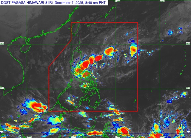
According to the Philippine Atmospheric and Geophysical Agency (PAGASA), the tropical depression officially made landfall in the central part of the country on the night of December 6, with the strongest winds near the center reaching 45 km/h, gusting to 60 km/h. The strong wind emission extends up to 150 km from the center of the tropical depression.

Ap thap nhiet doi da chinh thuc do bo dat lien Philippines va giam cuong do, tuy nhien van gay mua lon, gio manh tren dien rong. Anh: Pagasa
The tropical depression has officially made landfall in the Philippines and reduced its intensity, but still caused widespread heavy rain and strong winds. Photo: Pagasa

In response to the development of the tropical depression near the East Sea, the National Civil Defense Steering Committee sent a telegram requesting 7 ministries: National Defense, Public Security, Agriculture and Environment, Construction, Industry and Trade, Foreign Affairs, Science and Technology and 14 coastal provinces and cities from Quang Tri to An Giang - to be ready to deploy response measures to the tropical depression heading towards the East Sea.

Specifically, 14 provinces and cities include Quang Tri, Hue, Da Nang, Quang Ngai, Gia Lai, Dak Lak, Khanh Hoa, Lam Dong, Ho Chi Minh City, Dong Thap, Vinh Long, Can Tho, Ca Mau, An Giang.

In particular, on December 7, the People's Committee of Khanh Hoa province issued a telegram requesting departments, branches and localities to proactively monitor weather developments and deploy response measures for the tropical depression that is moving rapidly and is expected to enter the East Sea.

Organize the counting and strictly manage the means of transport going out to sea; promptly notify the location, direction of movement and developments of the tropical depression so that ship owners and captains can proactively avoid and not move into the danger zone.

Ninh Phương
TIN LIÊN QUAN

Tropical depression weakens but thunderstorms over a wide area

|

The tropical depression forecast near the East Sea is active in the Philippine area of responsibility, tending to weaken gradually.

Tropical depression is about to change direction to the East Sea, warning of bad weather

|

According to the latest tropical depression news, the tropical depression is in the eastern coast of Palawan Island (Philippines). Weather forecast for the East Sea will turn bad.

Weather forecast for December 8: Tropical depression officially enters the East Sea

|

Weather forecast for tomorrow, December 8, the East Sea officially welcomes the tropical depression. On land, there will be scattered thunderstorms across the country.

Dangerous area when tropical depression enters the East Sea, bad weather forecast

|

The tropical depression near the East Sea continues to move West Southwest, causing strong winds, large waves and directly affecting the sea weather.

Tropical depression officially makes landfall, heavy rain and wind

|

The tropical depression has officially made landfall in the central Philippines and accelerated into the East Sea in the next 24 hours.

Latest storm news: Tropical depression accelerates into the East Sea towards the South

|

According to the latest storm news, the tropical depression will maintain its intensity when making landfall in the Philippines before officially entering the East Sea.

Tropical depression weakens but thunderstorms over a wide area

Chí Long |

The tropical depression forecast near the East Sea is active in the Philippine area of responsibility, tending to weaken gradually.

Tropical depression is about to change direction to the East Sea, warning of bad weather

Ninh Phương |

According to the latest tropical depression news, the tropical depression is in the eastern coast of Palawan Island (Philippines). Weather forecast for the East Sea will turn bad.

Weather forecast for December 8: Tropical depression officially enters the East Sea

Ninh Phương |

Weather forecast for tomorrow, December 8, the East Sea officially welcomes the tropical depression. On land, there will be scattered thunderstorms across the country.

Dangerous area when tropical depression enters the East Sea, bad weather forecast

Ninh Phương |

The tropical depression near the East Sea continues to move West Southwest, causing strong winds, large waves and directly affecting the sea weather.

Tropical depression officially makes landfall, heavy rain and wind

Ninh Phương |

The tropical depression has officially made landfall in the central Philippines and accelerated into the East Sea in the next 24 hours.

Latest storm news: Tropical depression accelerates into the East Sea towards the South

Ninh Phương |

According to the latest storm news, the tropical depression will maintain its intensity when making landfall in the Philippines before officially entering the East Sea.