According to the new weather forecast from the Philippine Meteorological Agency ( pagasa), the tropical depression is completely within the Philippine responsibility area.
The tropical depression is at about 12.1 degrees North latitude - 125.6 degrees East longitude off the coast of Oras, Eastern Samar, Philippines. The tropical depression is moving west-northwest at a slow speed of about 10 km/h.
A thick cloud line from the edge of the tropical depression is affecting southeastern Luzon, while the tropical depression's cloud areas continue to affect much of Visayas in the next 24 hours.
These are important developments in the forecast of the new tropical depression.
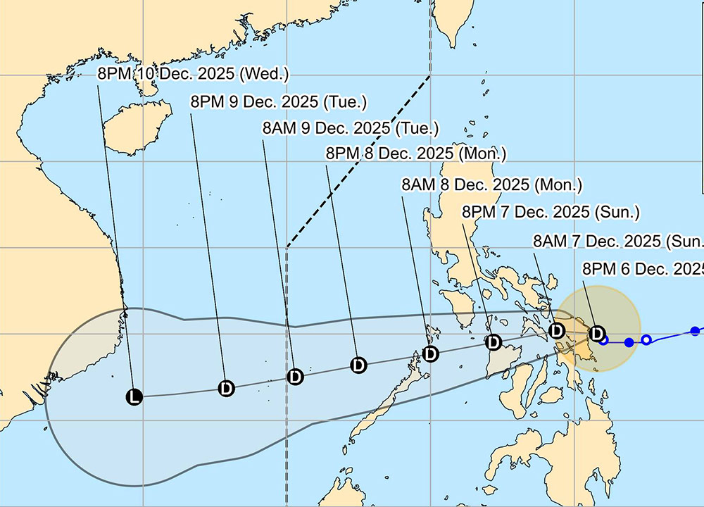
The latest storm news updated at 11pm on December 6 (local time) shows that the tropical depression is likely to strengthen and make landfall in Eastern Samar or Northern Samar on the night of December 6, early morning of December 7.
The tropical depression will then move westward, passing through much of Visayas through tomorrow. By Monday, December 8, the tropical depression will make landfall in the Sulu Sea off the coast of the Philippines and head north of Palawan and officially enter the East Sea.
In the next 24 hours, heavy rains will continue to appear in Mimaropa, Quezon, Bicol region and some areas of Visayas. Rainfall may reach 100-200 mm.
Tourists traveling through mountainous areas need to pay attention to the risk of landslides and flash floods according to the forecast of tropical depressions. Pay special attention to the latest storm information and limit sea travel during the tropical depression approaching the Philippine coast.
Strong seas continue to be warned in northern Quezon, Pulilio, Camarines Norte - Sur, Catanduanes, Albay, Cagayan, Isabela and Aurora, with waves from 2-5m.
The tropical depression is likely to maintain its intensity when it makes landfall in the Philippines, with a tendency to weaken into a low area due to dry air from the Northeast monsoon.
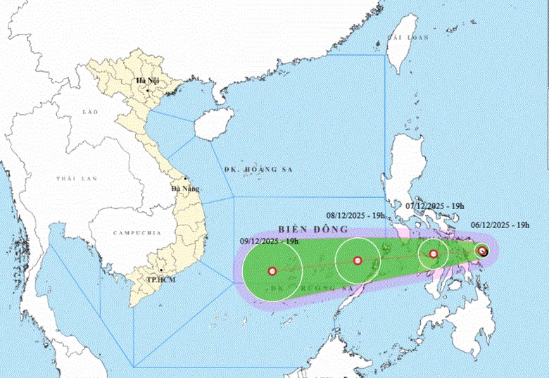
According to the National Center for Hydro-Meteorological Forecasting, in the next 48-72 hours, the tropical depression will change little in intensity.
The tropical depression continues to move in a West-Southwest direction, at a speed of about 20-25 km/h - an increase compared to the speed moving through the Philippines.
From early morning on December 8, the sea area in the East Central East Sea will have winds gradually increasing to level 6, gusting to level 8, waves 2-4m high, rough seas.
The forecast track of the tropical depression will be towards the South by 7:00 p.m. on December 8.
The tropical depression situation is still uncertain, not excluding the possibility of the tropical depression strengthening into storm No. 16 in the East Sea. Tourists on sea tours, island tours or small boats are advised not to go out to sea due to big waves, rough seas and bad weather.


