According to the latest storm forecast from the National Center for Hydro-Meteorological Forecasting, tropical depression Mirasol has left the Philippine mainland to enter the East Sea.
As of 7:00 a.m. on September 18, the center of the tropical depression was at about 19.8 degrees North latitude - 119.0 degrees East longitude, in the northeastern sea area of the North East Sea. The strongest wind near the center of the tropical depression is level 7 (50-61km/h), gusting to level 9.
The tropical depression is moving northwest at a speed of about 20km/h.
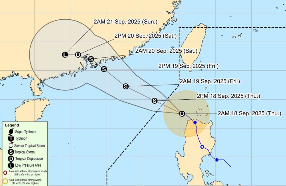
It is forecasted that by 7:00 a.m. on September 19, the tropical depression will move northwest at a speed of 15-20 km/h and is likely to strengthen into storm No. 8. The center of the storm is currently at about 21.9 degrees North latitude - 116.2 degrees East longitude, in the northern sea area of the North East Sea.
The strongest wind near the storm center is level 8-9, gusting to level 11. Natural disaster risk level: Level 3 for the northeastern sea area of the North East Sea.
By 7:00 a.m. on September 20, storm No. 8 moved northwest, slowing down to about 10-15km/h. The center of the storm is located at about 23.2 degrees North latitude - 113.5 degrees East longitude, in the area south of Guangdong province (China). The strongest wind near the storm center is level 8, gusting to level 10. Natural disaster risk level: Level 3 for the northern sea area of the North East Sea.
From the next 48 to 72 hours, the storm will move mainly in the West direction, traveling about 10km per hour and gradually weakening.
Due to the influence of the tropical depression about to become a storm in the East Sea, the northeastern sea area of the North East Sea will have winds gradually increasing to level 6-7, gusting to level 9; near the storm center, level 8-9, gusting to level 11, waves 3.0-5.0m high. The sea is very rough.
Ship operating in the above-mentioned dangerous areas are likely to be affected by thunderstorms, whirlwinds, strong winds, and large waves.
People and tourists planning to visit these coastal areas or areas where storms pass through should pay attention to weather forecasts. Check flight schedules and follow local instructions to avoid dangerous storms.


