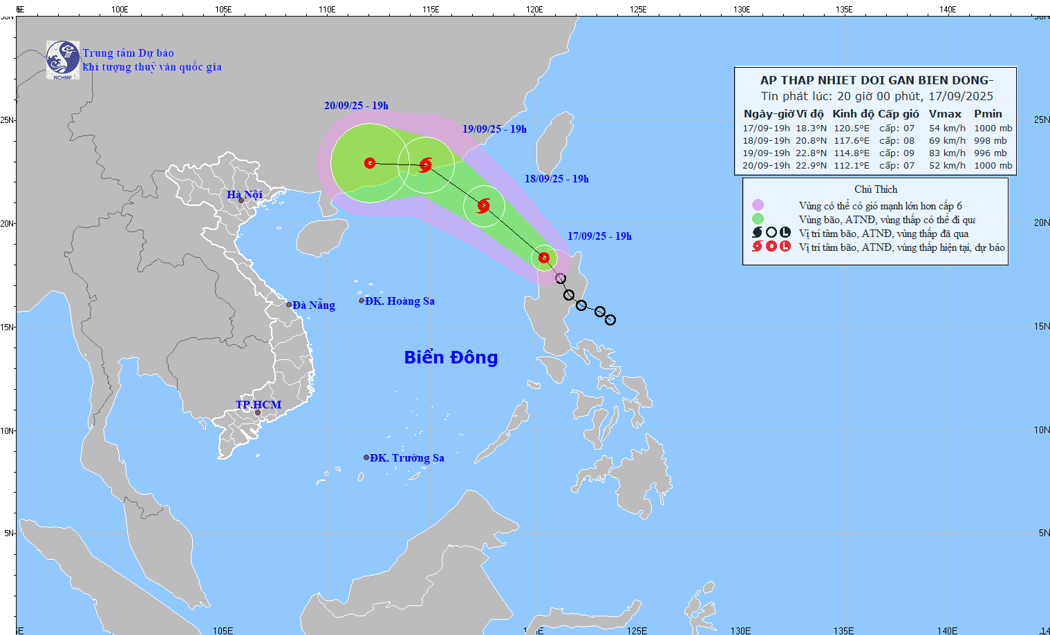
According to the latest weather forecast from the National Center for Hydro-Meteorological Forecasting, on the evening of September 17, the tropical depression is in the sea northwest of Luzon Island (Philippines).
The strongest wind near the center of the tropical depression is level 7 (50-61km/h), gusting to level 9. Moving northwest at a speed of about 15-20km/h.
It is forecasted that by the evening of September 18, the tropical depression will move northwest at a speed of 15-20 km/h, entering the East Sea and is likely to strengthen into storm No. 8.
The center of storm No. 8 at around 7pm on September 18 was at about 20.8 degrees North latitude - 117.6 degrees East longitude, in the northeastern sea of the North East Sea.
The strongest wind is level 8, gusting to level 10. The danger zone is identified as the north of the latitude of 17.5 degrees North and the east of the longitude of 116 degrees East.
The natural disaster risk level is assessed as level 3 for the northeastern sea area of the North East Sea.
By 7:00 p.m. on September 19, storm No. 8 continued to move northwest at a speed of about 15 km/h and was likely to strengthen.
The center of storm No. 8 is located at about 22.8 degrees North latitude - 114.8 degrees East longitude, in the sea south of Guangdong province (China).
The strongest wind is level 8-9, gusting to level 11. The danger zone is north of latitude 19 degrees North and east of longitude 113 degrees East. The natural disaster risk level continues to be at level 3 for the northeastern sea area of the North East Sea.
In the next 48 to 72 hours, storm No. 8 tends to move mainly westward, traveling about 10 km/h and gradually weakening.
The northeastern sea area of the North East Sea will have winds gradually increasing to level 6-7, gusting to level 9; In the area near the storm's center, there will be strong winds of level 8, gusting to level 10. Waves are 2.5 to 4.5 m high, rough seas.
People and tourists should note that boats operating in the above dangerous areas are likely to be affected by thunderstorms, whirlwinds, strong winds and large waves.
On land, the North will have scattered showers and thunderstorms, locally heavy rain, concentrated at night and in the morning.
Thanh Hoa to Thua Thien Hue will have scattered showers and thunderstorms, with some places having heavy rain.
From Da Nang to Lam Dong and the South in the afternoon and night, there will be rain, moderate rain, scattered thunderstorms, locally heavy to very heavy rain.
Weather forecast for tomorrow, September 18:
Hanoi Lowest temperature: 25-27 degrees Celsius Highest temperature: 31-33 degrees Celsius Cloudy, occasional showers and thunderstorms, intermittent sunshine during the day.
Light wind.During thunderstorms, there is a possibility of tornadoes, lightning and strong gusts of wind.
Northwest Lowest temperature: 23-26 degrees Celsius, some places below 22 degrees Celsius Highest temperature: 31-34 degrees Celsius Cloudy, scattered showers and thunderstorms, locally heavy rain, rain concentrated at night and morning.
Light wind.During thunderstorms, there is a possibility of tornadoes, lightning, hail and strong gusts of wind.
Northeast Lowest temperature: 24-27 degrees Celsius, mountainous areas below 23 degrees Celsius Highest temperature: 30-33 degrees Celsius, some places above 33 degrees Celsius Cloudy, scattered showers and thunderstorms at night and in the morning, locally heavy rain, rain concentrated at night and in the morning.
Light wind.During thunderstorms, there is a possibility of tornadoes, lightning, hail and strong gusts of wind.
Thanh Hoa to Thua Thien Hue Lowest temperature: 24-27 degrees Celsius Highest temperature: 29-32 degrees Celsius Cloudy, scattered showers and thunderstorms, locally heavy rain.
Light wind.During thunderstorms, there is a possibility of tornadoes, lightning, hail and strong gusts of wind.
South Central Coast Lowest temperature: 24-27 degrees Celsius Highest temperature: 30-33 degrees Celsius Cloudy, scattered showers and thunderstorms; tonight and tomorrow afternoon, there will be rain, moderate rain and scattered thunderstorms, locally heavy rain.
Southwest wind level 2-3.During thunderstorms, there is a possibility of tornadoes, lightning, hail and strong gusts of wind.
Central Highlands Lowest temperature: 19-22 degrees Celsius Highest temperature: 28-31 degrees Celsius Cloudy, scattered showers and thunderstorms; tonight and tomorrow afternoon, there will be rain, moderate rain and scattered thunderstorms, locally heavy rain.
Southwest wind level 2-3.During thunderstorms, there is a possibility of tornadoes, lightning, hail and strong gusts of wind.
Southern region Lowest temperature: 24-27 degrees Celsius Highest temperature: 30-33 degrees Celsius, some places above 33 degrees Celsius Cloudy, scattered showers and thunderstorms; tonight and tomorrow afternoon, there will be rain, moderate rain and scattered thunderstorms, locally heavy rain.
Southwest wind level 2-3.During thunderstorms, there is a possibility of tornadoes, lightning, hail and strong gusts of wind.
Ho Chi Minh City Lowest temperature: 24-26 degrees Celsius Highest temperature: 31-33 degrees Celsius Cloudy, scattered showers and thunderstorms; tonight and tomorrow afternoon, there will be rain, moderate rain and scattered thunderstorms, locally heavy rain.Southwest wind level 2-3.
During thunderstorms, there is a possibility of tornadoes, lightning, hail and strong gusts of wind.