
Many tourist destinations in the North have heavy rain
According to the National Center for Hydro-Meteorological Forecasting, from the evening of August 21 to August 23, the Northeast region, the south of Phu Tho and Thanh Hoa provinces will have moderate rain, heavy rain and thunderstorms, common rainfall of 70-150mm, locally over 300mm.
Lang Son, Bac Ninh, Quang Ninh and Hai Phong City will have heavy to very heavy rain, common rainfall of 150-250mm, locally over 400mm. Rain is likely to appear with high intensity, over 120mm in 3 hours.
For tourists planning to visit Northern destinations on weekends, especially in Quang Ninh, Hai Phong, Lang Son and mountainous areas, it is necessary to consider outdoor activities, trekking, visiting waterfalls or moving through roads at risk of flooding and landslides.
Heavy rain can also affect travel, especially during heavy rain. Visitors should check the forecast before departure and regularly update the weather situation at the destination.
In the afternoon and night of August 21, Nghe An, Central Highlands and Southern regions will have scattered showers and thunderstorms, common rainfall of 15-30mm, locally over 60mm.
In thunderstorms, there is a possibility of tornadoes, lightning and strong gusts of wind. Tourists who choose outdoor activities such as camping, mountain climbing, eco-tourism or traveling by waterway should pay special attention.
Northern sea tourism needs caution
The weather at sea will have notable developments in the last two days of the week.
On the night of August 21st and August 22nd, the Gulf of Tonkin, the northern sea area of the Northern East Sea, the sea area from Ca Mau to An Giang and the Gulf of Thailand will have showers and thunderstorms. The Gulf of Tonkin is likely to experience rain and storms.
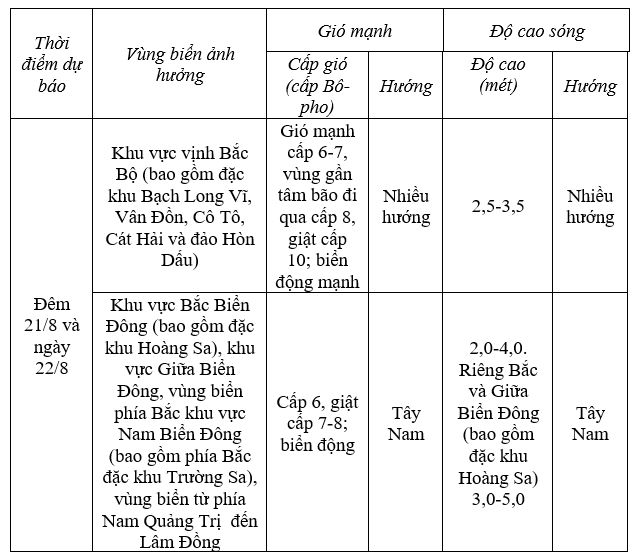
In thunderstorms, there is a possibility of tornadoes, strong gusts of wind at level 7-8, sea waves over 2m high. This may affect sea tourism activities, sightseeing boats, speedboats and water entertainment activities.
Especially, on the night of August 22nd and August 23rd, the Gulf of Tonkin will have strong winds of level 6-7; the area near the storm center passing through may be strong at level 8, gusting at level 10. Sea waves are 2-4m high, rough seas.
For sea tourist destinations in Quang Ninh and Hai Phong, tourists should proactively follow the announcements of functional agencies, transport units and destination management boards before participating in boat trips and island tours.
In addition to the Gulf of Tonkin, the North and Central East Sea areas, including the Hoang Sa special zone; the sea area north of the South East Sea area, including the North of the Truong Sa special zone; and the sea area from South Quang Tri to Lam Dong have strong Southwest winds at level 6, gusts at level 7-8. Sea waves in these areas are 2-4m high, especially the North and Central East Sea can be 3-5m high, rough seas.
The level of natural disaster risk at sea is warned at level 2; especially the Gulf of Tonkin, including Bach Long Vi, Van Don, Co To, Cat Hai and Hon Dau island areas, at level 3. All ships operating in the above sea areas are at high risk of being affected by strong winds and large waves.
What should tourists do if they have planned to go on weekends?
For land trips, tourists should prioritize indoor activities in areas forecast to have heavy rain, and prepare raincoats, umbrellas and suitable travel plans.
Trekking, mountain climbing, camping or visiting river, stream, and waterfall areas should be carefully considered when prolonged heavy rain.
For sea tourism, especially in the Gulf of Tonkin, tourists should not be subjective when they see that the weather in the accommodation area is still stable. Strong winds and big waves offshore can cause boat schedules, island tours or sea activities to change rapidly.


