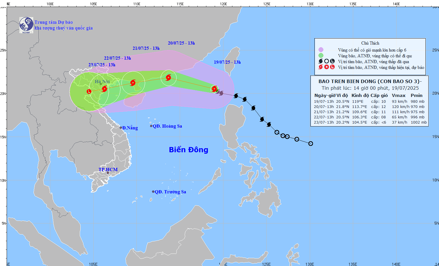
According to the storm news from the National Center for Hydro-Meteorological Forecasting, today, July 20, storm No. 3 Wipha is continuing to move deep into the East Sea.
It is forecasted that by 7:00 a.m. this morning, storm No. 3 will move in a West-Northwest direction at a speed of about 20 km/h, entering the East Sea and strengthening. The center of the storm is located at about 21.8 degrees North latitude - 115.7 degrees East longitude, in the northern sea area of the North East Sea; about 600 km east of the Lusi Peninsula (China).
The strongest wind near the storm center is level 10-11, gusting to level 13. Natural disaster risk level: level 3, for the eastern sea area of the North East Sea.
By 4:00 p.m. on July 20, the storm will move west-northwest at a speed of about 20-25 km/h and is likely to strengthen.
The center of the storm is located at about 21.7 degrees North latitude - 113.0 degrees East longitude, in the northern sea area of the North East Sea; about 370 km east of the Lusi Peninsula (China). The strongest wind near the storm center is level 11-12, gusting to level 15.
Due to the influence of storm No. 3, the North East Sea area has strong winds of level 8-10, near the center of the storm level 11-12, gusts of level 15; waves 4.0-6.0m high.
Ships operating in the danger zone should stay away from the storm's affected area, regularly update new information and strictly implement storm response instructions from local authorities.
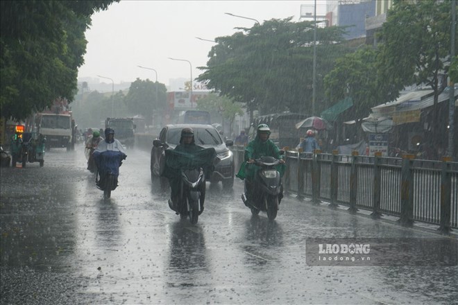
On land, the Northern region will be cloudy, with scattered showers and thunderstorms in the evening and at night, with some places having heavy rain; sunny during the day, especially Lao Cai, Yen Bai and the western area of Phu Tho province will have hot weather.
The area from Thanh Hoa to Hue and the South Central Coast will be cloudy, with showers and thunderstorms in some places in the evening and at night; sunny during the day, some places will be hot and hot. The highest temperature is over 37 degrees Celsius.
Other areas are cloudy, with scattered showers and thunderstorms in some places, with scattered showers and thunderstorms in the afternoon and evening, with some places having heavy rain.
People and tourists should be on guard against thunderstorms that can cause tornadoes, lightning, and strong gusts of wind.
Limit outdoor activities, going out to sea, and taking island tours in areas that are about to be affected by storm No. 3 Wipha.
Weather forecast for today, July 20 at:
City. Hanoi
Lowest temperature: 26-28 degrees Celsius.
Highest temperature: 34-36 degrees Celsius.
Cloudy, showers and thunderstorms in the evening and at night, locally heavy rain; hot sunny day.Light wind.During thunderstorms, there is a possibility of tornadoes, lightning, hail and strong gusts of wind.
Northwest
Lowest temperature: 23-26 degrees Celsius, some places below 23 degrees Celsius.
Highest temperature: 30-33 degrees Celsius; Lao Cai, Yen Bai and the western area of Phu Tho 33-36 degrees Celsius.
Cloudy, scattered showers and thunderstorms in the evening and at night, locally heavy rain; sunny day, especially Lao Cai, Yen Bai and the western area of Phu Tho have hot sunshine.Light wind.During thunderstorms, there is a possibility of tornadoes, lightning, hail and strong gusts of wind.
Northeast
Lowest temperature: 25-28 degrees Celsius.
Highest temperature: 33-36 degrees Celsius.
Cloudy, scattered showers and thunderstorms in the evening and at night, locally heavy rain; hot sunny day.Light wind.During thunderstorms, there is a possibility of tornadoes, lightning, hail and strong gusts of wind.
Thanh Hoa to Hue
Lowest temperature: 26-29 degrees Celsius.
Highest temperature: 34-37 degrees Celsius, some places above 37 degrees Celsius.
Cloudy, showers and thunderstorms in the evening and at night, hot sunny during the day, some places are very hot.West to southwest wind level 2-3.During thunderstorms, there is a possibility of tornadoes, lightning, hail and strong gusts of wind.
South Central Coast
Lowest temperature: 26-29 degrees Celsius.
Highest temperature: 34-37 degrees Celsius.
Cloudy, showers and thunderstorms in the evening and at night; sunny during the day, some places are hot; the North is hot.Southwest wind level 2-3.During thunderstorms, there is a possibility of tornadoes, lightning, hail and strong gusts of wind.
Central Highlands
Lowest temperature: 20-23 degrees Celsius.
Highest temperature: 26-29 degrees Celsius, some places above 29 degrees Celsius.
Cloudy, scattered showers and thunderstorms in some places, in the afternoon and at night there are scattered showers and thunderstorms, locally heavy rain in some places.Southwest wind level 2-3.During thunderstorms, there is a possibility of tornadoes, lightning and strong gusts of wind.
Southern region
Lowest temperature: 24-27 degrees Celsius.
Highest temperature: 29-32 degrees Celsius, some places above 32 degrees Celsius.
Cloudy, scattered showers and thunderstorms in some places, scattered showers and thunderstorms in the afternoon and evening, locally heavy rain in some places.Southwest wind level 2-3.During thunderstorms, there is a possibility of tornadoes, lightning and strong gusts of wind.
Ho Chi Minh City
Lowest temperature: 25-27 degrees Celsius.
Highest temperature: 30-32 degrees Celsius.
Cloudy, scattered showers and thunderstorms in some places, in the afternoon and evening there will be scattered showers and thunderstorms, locally heavy rain in some places.Southwest wind level 2-3.During thunderstorms, there is a possibility of tornadoes, lightning and strong gusts of wind.