According to the new weather forecast from the National Center for Hydro-Meteorological Forecasting, the North and Central regions will have hot weather again after thunderstorms due to the impact of storm No. 1 Wutip.
On the evening of June 14, storm No. 1 Wutip is in the southwestern area of Guangdong province (China), with an intensity of level 9 (75-88km/h), gusting to level 11.
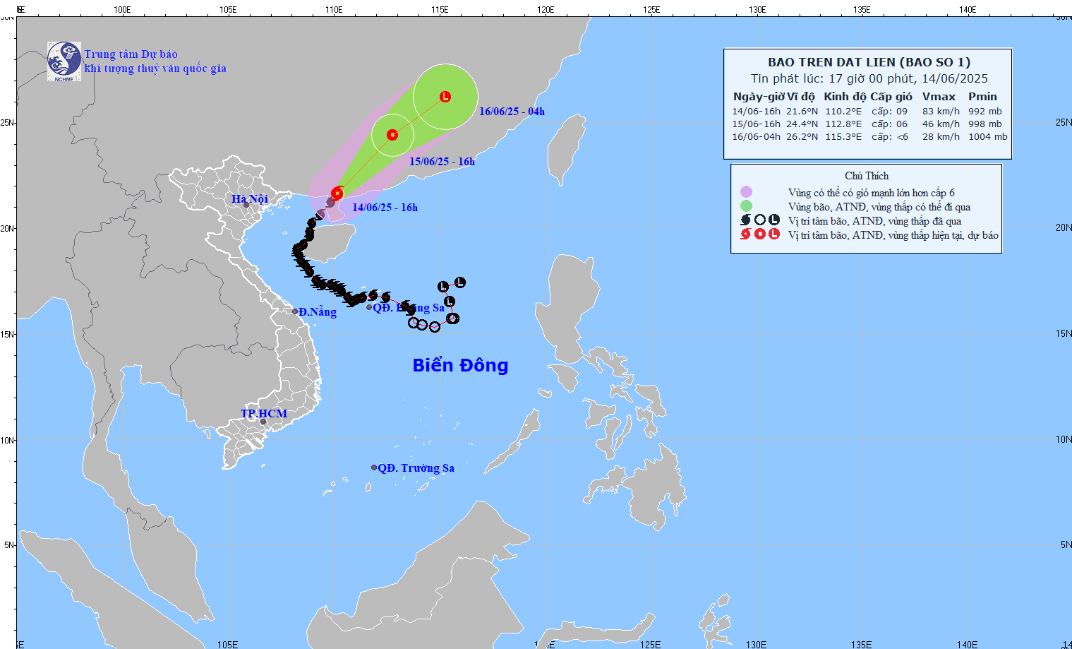
Due to the influence of the storm, the eastern part of the Northern Gulf of Tonkin will have strong winds of level 7-8, gusts of level 10, waves 2.0-4.0m high, and rough seas.
The Northwest of the Gulf of Tonkin (including Co To and Bach Long Vi island districts), the Northwest of the North East Sea will have strong winds of level 5, sometimes level 6, gusts of level 8, waves 2.0-3.0m high, rough seas.
Storm No. 1 is forecast to weaken into a tropical depression on June 15.
The North will have hot weather, some places will have severe heat with the highest temperature of 35-37 degrees Celsius, some places will be over 37 degrees Celsius; the lowest humidity is 55-60%.
From Thanh Hoa to Phu Yen, there will be hot weather, some places will be very hot with the highest temperature of 35-37 degrees Celsius, some places will be above 38 degrees Celsius, the lowest humidity is 50-55%.
The forecast temperature may be 2-4 degrees Celsius different from the actual outdoor temperature, or even higher if there are heat-absorbing surfaces such as concrete and asphalt.
People and tourists in the North and Central regions should be on guard against hot weather that can cause dehydration, exhaustion and stroke due to heat stroke when exposed to high temperatures for a long time.
Meanwhile, the Central Highlands and the South will have scattered showers and thunderstorms in some places, with scattered showers in the late afternoon and evening and thunderstorms in some places.
During thunderstorms, there is a possibility of tornadoes, lightning and strong gusts of wind.

Weather forecast for tomorrow, June 15
Hanoi
Cloudy, no rain at night, hot days, some places are very hot. Light wind.
The lowest temperature is from 26-28 degrees Celsius.
The highest temperature is from 35-37 degrees Celsius, some places are over 37 degrees Celsius.
Northwest
Cloudy, showers and thunderstorms in some places in the evening and at night, hot sunny days, some places are very hot. Light wind.
The lowest temperature is from 24-27 degrees Celsius, some places below 23 degrees Celsius.
The highest temperature is from 35-37 degrees Celsius, some places above 37 degrees Celsius; Lai Chau and Dien Bien are from 32-35 degrees Celsius.
Northeast
Cloudy, showers and thunderstorms in some places in the evening and at night, hot sunny days, some places are very hot. Light wind.
The lowest temperature is from 25-28 degrees Celsius, in mountainous areas it is below 24 degrees Celsius.
The highest temperature is from 35-37 degrees Celsius, in some places it is above 37 degrees Celsius.
Area from Thanh Hoa to Hue
Cloudy, showers and thunderstorms in some places in the evening and at night, hot sunny days, some places are very hot. Southwest wind level 2-3.
The lowest temperature is from 24-27 degrees Celsius.
The highest temperature is from 35-37 degrees Celsius, some places are over 37 degrees Celsius.
Area from Da Nang to Binh Thuan
Cloudy, showers and thunderstorms in some places in the evening and at night; sunny during the day, some places are hot; in the North, it is hot during the day, some places are very hot. Southwest wind level 2-3, coastal areas level 3-4.
Lowest temperature from 25-28 degrees Celsius.
Highest temperature: North from 35-37 degrees Celsius; South from 32-35 degrees Celsius.
Central Highlands
Cloudy, scattered showers and thunderstorms in the late afternoon and evening; sunny day. Southwest wind level 2-3.
The lowest temperature is from 20-23 degrees Celsius.
The highest temperature is from 28-31 degrees Celsius, some places are over 31 degrees Celsius.
Southern region
Cloudy, scattered showers and thunderstorms in the late afternoon and evening; sunny day. Southwest wind level 2-3.
The lowest temperature is from 24-27 degrees Celsius.
The highest temperature is from 31-34 degrees Celsius, some places are over 34 degrees Celsius.


