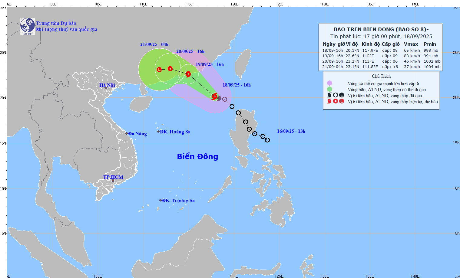
According to the latest storm news from the National Center for Hydro-Meteorological Forecasting, at around 4:00 p.m. on September 18, the tropical depression officially strengthened into storm No. 8 (international name Mitag).
The center of the storm is at about 20.1 degrees North latitude; 117.9 degrees East longitude, in the northeastern sea area of the North East Sea. The strongest wind near the storm center is level 8 (62-74km/h), gusting to level 10. Moving northwest, speed 15-20km/h.
By 4:00 p.m. on September 19, storm No. 8 continued to move northwest, about 15km/h and continued to strengthen.
The storm's location is around 22.6 degrees North latitude - 115.0 degrees East longitude; in the southern coastal area of Guangdong province (China). The intensity reaches level 9, gust level 11.
Natural disaster risk level at Level 3: northeastern sea area of the North East Sea.
Due to the influence of storm No. 8 Mitag, the northeastern sea area of the North East Sea will have strong winds of level 6-7, gusts of level 9; the area near the storm's eye will have strong winds of level 8-9, gusts of level 11, waves 3.0-5.0m high. The sea is very rough.
According to the Joint Typhoon Warning Center (JTWC), Mitag is forecast to continue moving northwest under the influence of the southwest edge of the subtropical high pressure. In the next 24-36 hours, the storm is likely to make landfall, expected to make landfall in the area east of Hong Kong (China).
People and tourists need to be careful, boats operating in the above-mentioned dangerous areas are likely to be affected by thunderstorms, whirlwinds, strong winds, and large waves.
Weather forecast for tomorrow, September 19th nationwide:
Hanoi Lowest temperature: 23-26 degrees Celsius Highest temperature: 31-33 degrees Celsius Cloudy, occasional showers and thunderstorms at night; intermittent sunny days.
Light wind.During thunderstorms, there is a possibility of tornadoes, lightning and strong gusts of wind.
Northwest Lowest temperature: 23-26 degrees Celsius, some places below 22 degrees Celsius Highest temperature: 31-34 degrees Celsius Cloudy, scattered showers and thunderstorms, especially in the South Phu Tho area.
Light wind.During thunderstorms, there is a possibility of tornadoes, lightning and strong gusts of wind.
Northeast Lowest temperature: 23-26 degrees Celsius, mountainous areas below 22 degrees Celsius Highest temperature: 30-33 degrees Celsius, some places above 33 degrees Celsius Cloudy, scattered showers and thunderstorms, scattered showers and thunderstorms in the plains and coastal areas.
Light wind.During thunderstorms, there is a possibility of tornadoes, lightning and strong gusts of wind.
Thanh Hoa to Hue Lowest temperature: 23-26 degrees Celsius Highest temperature: 29-32 degrees Celsius Cloudy, scattered showers and thunderstorms, locally heavy rain.
Light wind.During thunderstorms, there is a possibility of tornadoes, lightning, hail and strong gusts of wind.
South Central Coast Lowest temperature: 23-26 degrees Celsius Highest temperature: 29-32 degrees Celsius Cloudy, showers and scattered thunderstorms at night, locally heavy to very heavy rain; showers and thunderstorms in some places during the day; scattered showers and thunderstorms tomorrow evening, locally heavy rain in some places.
Southwest wind level 2-3.During thunderstorms, there is a possibility of tornadoes, lightning, hail and strong gusts of wind.
Central Highlands Lowest temperature: 20-23 degrees Celsius Highest temperature: 27-30 degrees Celsius, some places above 30 degrees Celsius Cloudy, scattered showers and thunderstorms at night, locally heavy to very heavy rain; showers and thunderstorms in some places during the day; scattered showers and thunderstorms tomorrow evening, locally heavy rain in some places.
Southwest wind level 2-3.During thunderstorms, there is a possibility of tornadoes, lightning, hail and strong gusts of wind.
Southern region Lowest temperature: 23-26 degrees Celsius Highest temperature: 29-32 degrees Celsius, some places above 32 degrees Celsius Cloudy, scattered showers and thunderstorms at night, locally heavy to very heavy rain; showers and thunderstorms in some places during the day; scattered showers and thunderstorms tomorrow evening, locally heavy rain in some places.
Southwest wind level 2-3.During thunderstorms, there is a possibility of tornadoes, lightning, hail and strong gusts of wind.
Ho Chi Minh City Lowest temperature: 24-26 degrees Celsius Highest temperature: 30-33 degrees Celsius Cloudy, showers and scattered thunderstorms at night, locally heavy to very heavy rain; showers and thunderstorms in some places during the day; scattered showers and thunderstorms tomorrow evening, locally heavy rain in some places.Southwest wind level 2-3.
During thunderstorms, there is a possibility of tornadoes, lightning, hail and strong gusts of wind.


