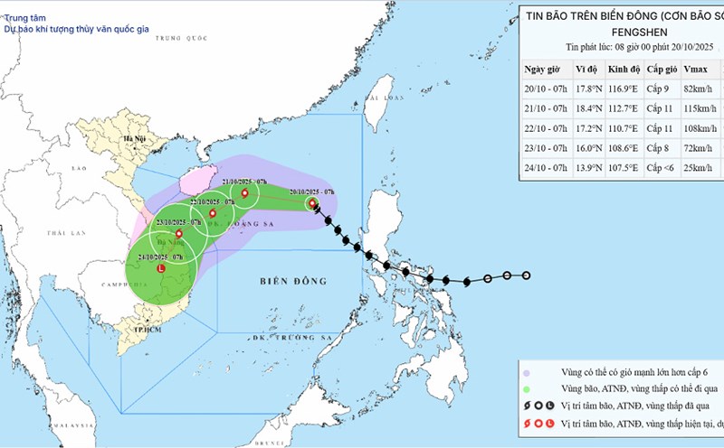
According to the new weather forecast from the National Center for Hydro-Meteorological Forecasting, on the night of October 20, the center of the storm was at about 18.5° North latitude - 114.0° East longitude, about 270 km northeast of the Hoang Sa archipelago.
The strongest wind near the storm center is level 9-10 (75-102 km/h), gusting to level 12. The storm is moving west-northwest at a speed of about 20 km/h.
It is forecasted that by the evening of October 21, the storm will move westward, then turn west-southwest at a speed of 10-15 km/h, in the area north of the Hoang Sa archipelago. The wind intensity increased to level 10-11, gusting to level 13.
The natural disaster risk level is determined at level 3 for the northern East Sea (including the Hoang Sa archipelago) and the southern sea of Quang Tri - Quang Ngai (including Ly Son island).
The northern East Sea area (including Hoang Sa archipelago) has strong winds of level 7-8, near the storm center strong winds of level 9-11, gusting to level 13. Waves are 3.0-5.0 m high, near the center of the storm there are waves 5.0-7.0 m high, the sea is very rough.
The sea area from southern Quang Tri to Quang Ngai (including Ly Son Island) will have strong winds of level 6, from the morning of October 22 increasing to level 7; the area near the storm center will have strong winds of level 8-9, gusting to level 11. Waves are 3.0-5.0 m high, the sea is very rough.
All ships and boats in the danger zone need to pay special attention because they are likely to be affected by thunderstorms, tornadoes, strong winds and large waves.

Due to the influence of the storm's circulation combined with cold air and winter wind disturbances, from the night of October 22 to October 26, the area from Ha Tinh to Quang Ngai will have widespread heavy rain.
Ha Tinh - northern Quang Tri and Quang Ngai areas will have common rainfall from 200-400 mm, some places over 500 mm.
The southern Quang Tri - Da Nang area will have very heavy rainfall, generally 500-700 mm, locally over 900 mm.
Heavy rain is likely to last until the end of October 2025, causing a high risk of flash floods, landslides in mountainous areas and flooding in low-lying areas and urban areas.
Localities need to proactively ensure the safety of reservoirs, and at the same time prepare flood response plans on rivers from Quang Tri to Quang Ngai that are likely to reach and exceed alert level 3. The risk level of natural disasters due to floods and inundation is assessed at level 3.
Weather forecast for today, October 21:
City. Hanoi
Lowest temperature: 21-23 degrees Celsius
Highest temperature: 29-31 degrees Celsius
Cloudy, no rain at night; sunny during the day. Northeast wind level 3.
Northwest
Lowest temperature: 19-22 degrees Celsius, high mountainous areas below 16 degrees Celsius
Highest temperature: 28-31 degrees Celsius
Cloudy, scattered showers at night; sunny during the day. Light wind. Cold at night and morning, some places are cold.
Northeast
Lowest temperature: 20-23 degrees Celsius, high mountainous areas below 16 degrees Celsius
Highest temperature: 28-31 degrees Celsius
Cloudy, no rain at night; sunny during the day. Northeast wind level 3, especially in coastal areas level 3-4. Cold at night and morning, some mountainous areas are cold.
Thanh Hoa to Hue
Lowest temperature: 22-25 degrees Celsius
Highest temperature: 28-31 degrees Celsius
Cloudy, with showers and thunderstorms in some places; in the South, there will be rain, showers and scattered thunderstorms, with some places having heavy rain. North to northwest wind level 3, coastal areas level 3-4. During thunderstorms, there is a possibility of tornadoes, lightning and strong gusts of wind.
South Central Coast
Lowest temperature: 23-26 degrees Celsius
Highest temperature: 29-32 degrees Celsius
Cloudy, in the north there is rain, scattered showers and thunderstorms, locally heavy rain; in the south there are showers and thunderstorms in some places, in the afternoon and evening there are scattered showers and thunderstorms, locally heavy rain. Northeast wind level 2-3. During thunderstorms, there is a possibility of tornadoes, lightning and strong gusts of wind.
Central Highlands
Lowest temperature: 19-22 degrees Celsius
Highest temperature: 27-30 degrees Celsius, some places above 30 degrees Celsius
Cloudy, with showers and thunderstorms in some places; in the afternoon and evening, there will be scattered showers and thunderstorms. Light wind. During thunderstorms, there is a possibility of tornadoes, lightning, hail and strong gusts of wind.
Southern region
Lowest temperature: 23-26 degrees Celsius
Highest temperature: 31-34 degrees Celsius
Cloudy, with showers and thunderstorms in some places; in the afternoon and evening, there will be scattered showers and thunderstorms, with some places having heavy rain. Light wind. During thunderstorms, there is a possibility of tornadoes, lightning, hail and strong gusts of wind.
Ho Chi Minh City
Lowest temperature: 24-26 degrees Celsius
Highest temperature: 32-34 degrees Celsius
Cloudy, with showers and thunderstorms in some places; in the afternoon and evening, there will be scattered showers and thunderstorms, with some places having heavy rain. Light wind. During thunderstorms, there is a possibility of tornadoes, lightning, hail and strong gusts of wind.