According to the latest weather forecast from the National Center for Hydro-Meteorological Forecasting (NCHMF), on September 21, super typhoon RAGASA had the strongest wind near the storm's center at level 14-15 (150-183km/h), gusting above level 17. The storm is moving west-northwest at a speed of about 15-20km/h.
In the next 24 to 72 hours, the super typhoon is forecast to continue to strengthen.
At 1:00 p.m. on September 22, the center of the storm was at about 19.8 degrees North latitude - 122.2 degrees East longitude, about 120km north of Luzon Island, strong at level 16-17, gusting above level 17. The northeastern sea area of the North East Sea is at level 3 natural disaster risk.
At 1:00 p.m. on September 23, the storm moved into the East Sea, at about 20.7 degrees North latitude - 118.2 degrees East longitude, continuing to maintain the intensity of level 16-17, gusting above level 17. The sea area north of latitude 18.0 degrees North latitude and east of longitude 115.5 degrees East longitude is warned of natural disaster risk level 4.
At 1:00 p.m. on September 24, the storm was at about 21.8 degrees North latitude - 113.8 degrees East longitude, in the waters of Guangdong province (China), strong at level 15, gusting above level 17; the waters north of latitude 18.5 degrees North latitude and east of longitude 109.5 degrees East longitude were at level 4 natural disaster risk.
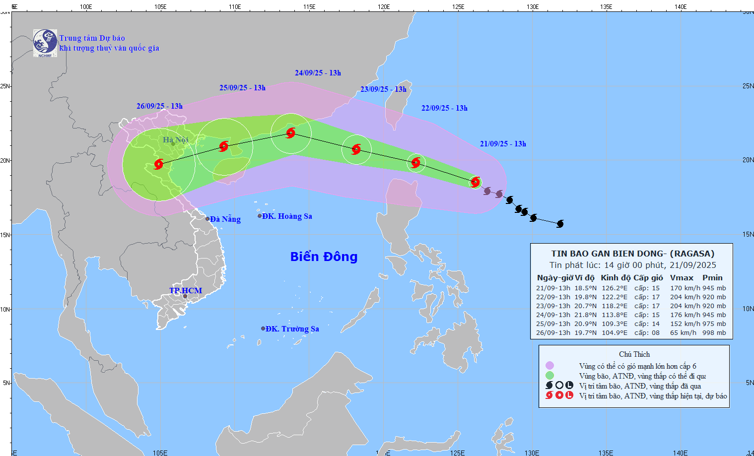
In the next 72 to 120 hours, the storm will move in the West Southwest direction, traveling about 20km per hour and tending to weaken gradually.
At sea, from September 22, the sea area east of the North East Sea will gradually increase to level 8-9, then increase to level 10-14; The area near the storm's eye will have strong winds of level 15-17, gusting above level 17. Waves are over 10m high, the sea is rough. Ship operating in the dangerous area is at risk of being affected by thunderstorms, whirlwinds, strong winds and large waves.
On land, the weather forecast from the night of September 21 to September 23 is that the North and Central Highlands will have scattered showers and thunderstorms, with some places having heavy to very heavy rain.
Area from Nghe An to Hue City, the South Central Coast and Southeast region: scattered showers and thunderstorms in the afternoon and evening, locally heavy rain.
According to the forecast of the Philippine Meteorological Agency, super typhoon Ragasa will enter the East Sea from around the evening of September 22 to the early morning of September 23.

Weather forecast for tomorrow, September 22:
Hanoi Lowest temperature: 25-27 degrees Celsius Highest temperature: 30-32 degrees Celsius Cloudy weather, scattered showers and thunderstorms, light winds.
During thunderstorms, there is a possibility of tornadoes, lightning, hail and strong gusts of wind.
Northwest Lowest temperature: 22-25 degrees Celsius, some places below 22 degrees Celsius Highest temperature: 31-34 degrees Celsius Cloudy weather, scattered showers and thunderstorms, locally heavy to very heavy rain, light wind.
During thunderstorms, there is a possibility of tornadoes, lightning and strong gusts of wind.
Northeast Lowest temperature: 23-26 degrees Celsius, mountainous areas below 22 degrees Celsius Highest temperature: 30-33 degrees Celsius Cloudy weather, scattered showers and thunderstorms, locally heavy to very heavy rain, light wind.
During thunderstorms, there is a possibility of tornadoes, lightning and strong gusts of wind.
Thanh Hoa to Hue Lowest temperature: 23-26 degrees Celsius Highest temperature: 30-33 degrees Celsius Cloudy weather, scattered showers and thunderstorms; scattered showers and thunderstorms tonight and tomorrow afternoon, locally heavy rain, light wind.
During thunderstorms, there is a possibility of tornadoes, lightning, hail and strong gusts of wind.
South Central Coast Lowest temperature: 23-26 degrees Celsius Highest temperature: 31-34 degrees Celsius, some places above 34 degrees Celsius Cloudy weather, scattered showers and thunderstorms; scattered showers and thunderstorms tonight and tomorrow afternoon, locally heavy rain, southwest wind level 2-3.
During thunderstorms, there is a possibility of tornadoes, lightning, hail and strong gusts of wind.
Central Highlands Lowest temperature: 20-23 degrees Celsius Highest temperature: 27-30 degrees Celsius Cloudy weather, scattered showers and thunderstorms, locally heavy to very heavy rain, southwest wind level 2-3.
During thunderstorms, there is a possibility of tornadoes, lightning, hail and strong gusts of wind.
Southern region Lowest temperature: 24-27 degrees Celsius Highest temperature: 29-32 degrees Celsius, some places above 32 degrees Celsius Cloudy weather, scattered showers and thunderstorms; scattered showers and thunderstorms tonight and tomorrow afternoon, locally heavy rain, southwest wind level 2-3.
During thunderstorms, there is a possibility of tornadoes, lightning, hail and strong gusts of wind.
Ho Chi Minh City Lowest temperature: 24-26 degrees Celsius Highest temperature: 28-30 degrees Celsius Cloudy weather, scattered showers and thunderstorms; scattered showers and thunderstorms tonight and tomorrow afternoon, locally heavy rain, southwest wind level 2-3.
During thunderstorms, there is a possibility of tornadoes, lightning, hail and strong gusts of wind.


