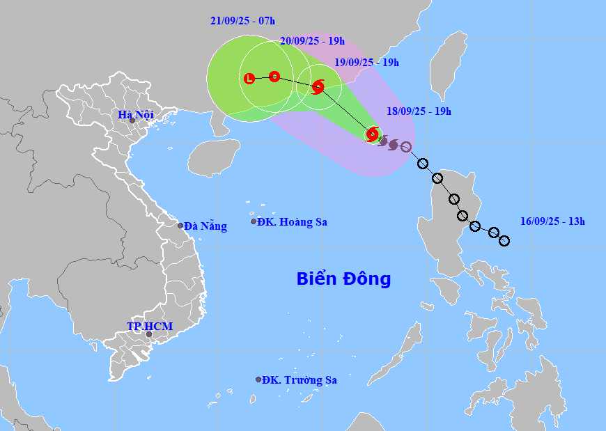
According to the National Center for Hydro-Meteorological Forecasting, on the morning of September 19, storm No. 8 was active in the East Sea.
By 7:00 a.m. on September 19, the tropical depression will move northwest at a speed of 15-20 km/h and is likely to strengthen into storm No. 8. The center of the storm is currently at about 21.9 degrees North latitude - 116.2 degrees East longitude, in the northern sea area of the North East Sea.
The strongest wind near the storm center is level 8-9, gusting to level 11. Natural disaster risk level: Level 3 for the northeastern sea area of the North East Sea.
By 7:00 p.m. the same day, storm No. 8 moved northwest at a speed of about 15km/h and continued to strengthen. The center of the storm is located at about 22.7 degrees North latitude - 114.8 degrees East longitude, in the southern coastal area of Guangdong province (China).
The strongest wind near the storm center is level 9, gusting to level 11. Natural disaster risk level: Level 3 for the northeastern sea area of the North East Sea.
After that, storm No. 8 continued to move deeper into the mainland area south of Quang Dong province and gradually weakened into a tropical depression.
Due to the influence of storm No. 8, the northeastern sea area of the North East Sea will have strong winds of level 6-7, gusting to level 9; the area near the storm's eye will have strong winds of level 8-9, gusting to level 11, waves 3.0-5.0m high. The sea is very rough.
Ship operating in the above-mentioned dangerous areas are likely to be affected by thunderstorms, whirlwinds, strong winds, and large waves.
People and tourists planning to visit these coastal areas or areas affected by storms should pay attention to weather forecasts. Tuan follows local instructions to ensure safety.
Weather forecast for today, September 19th nationwide:
Hanoi
Lowest temperature: 23-26 degrees Celsius Highest temperature: 31-33 degrees Celsius Cloudy, occasional showers and thunderstorms at night; intermittent sunny days.
Light wind.During thunderstorms, there is a possibility of tornadoes, lightning and strong gusts of wind.
Northwest
Lowest temperature: 23-26 degrees Celsius, some places below 22 degrees Celsius Highest temperature: 31-34 degrees Celsius Cloudy, scattered showers and thunderstorms, especially in the South Phu Tho area.
Light wind.During thunderstorms, there is a possibility of tornadoes, lightning and strong gusts of wind.
Northeast
Lowest temperature: 23-26 degrees Celsius, mountainous areas below 22 degrees Celsius Highest temperature: 30-33 degrees Celsius, some places above 33 degrees Celsius Cloudy, scattered showers and thunderstorms, scattered showers and thunderstorms in the plains and coastal areas.
Light wind.During thunderstorms, there is a possibility of tornadoes, lightning and strong gusts of wind.
Thanh Hoa to Hue
Lowest temperature: 23-26 degrees Celsius Highest temperature: 29-32 degrees Celsius Cloudy, scattered showers and thunderstorms, locally heavy rain.
Light wind.During thunderstorms, there is a possibility of tornadoes, lightning, hail and strong gusts of wind.
South Central Coast
Lowest temperature: 23-26 degrees Celsius Highest temperature: 29-32 degrees Celsius Cloudy, scattered showers and thunderstorms at night, locally heavy to very heavy rain; showers and thunderstorms in some places during the day; scattered showers and thunderstorms in the evening, locally heavy rain in some places.
Southwest wind level 2-3.During thunderstorms, there is a possibility of tornadoes, lightning, hail and strong gusts of wind.
Central Highlands
Lowest temperature: 20-23 degrees Celsius Highest temperature: 27-30 degrees Celsius, some places above 30 degrees Celsius Cloudy, scattered showers and thunderstorms at night, locally heavy to very heavy rain in some places; showers and thunderstorms in some places during the day; scattered showers and thunderstorms in the evening, locally heavy rain in some places.
Southwest wind level 2-3.During thunderstorms, there is a possibility of tornadoes, lightning, hail and strong gusts of wind.
Southern region
Lowest temperature: 23-26 degrees Celsius Highest temperature: 29-32 degrees Celsius, some places above 32 degrees Celsius Cloudy, scattered showers and thunderstorms at night, locally heavy to very heavy rain; showers and thunderstorms in some places during the day; scattered showers and thunderstorms in the evening, locally heavy rain in some places.
Southwest wind level 2-3.During thunderstorms, there is a possibility of tornadoes, lightning, hail and strong gusts of wind.
Ho Chi Minh City
Lowest temperature: 24-26 degrees Celsius Highest temperature: 30-33 degrees Celsius Cloudy, scattered showers and thunderstorms at night, locally heavy to very heavy rain; showers and thunderstorms in some places during the day; scattered showers and thunderstorms in the evening, locally heavy rain in some places.
Southwest wind level 2-3.During thunderstorms, there is a possibility of tornadoes, lightning, hail and strong gusts of wind.


