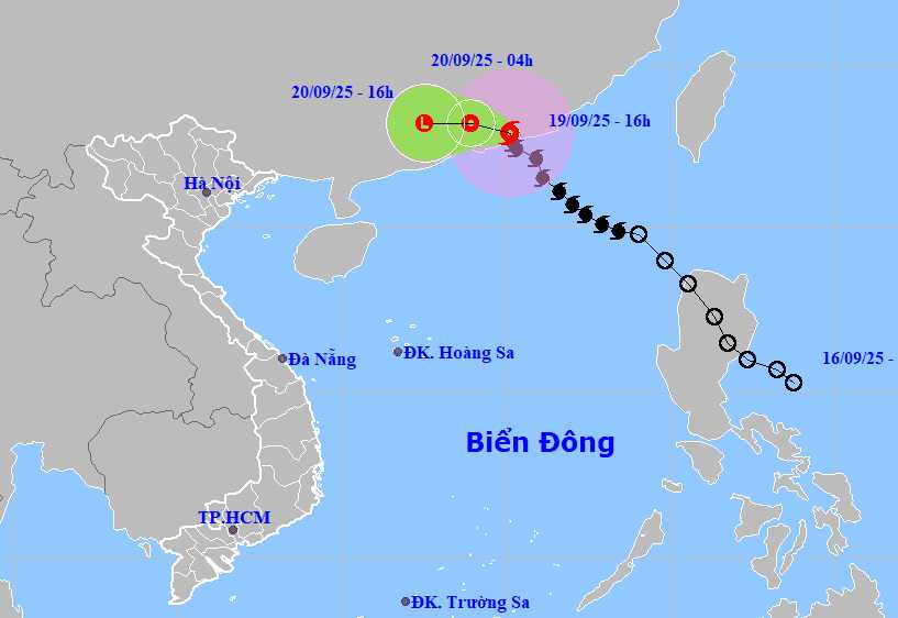
According to the National Center for Hydro-Meteorological Forecasting, on the morning of September 20, storm No. 8 Mitag weakened in Quangdong province (China).
As of 4:00 a.m. on September 20, the storm moved west-northwest at a speed of 10-15 km/h, weakening into a tropical depression on the mainland in the South of Quang Dong province. The center of the tropical depression is located at about 23.2 degrees North latitude - 113.9 degrees East longitude. The strongest wind near the center of the tropical depression is level 6, gusting to level 8.
At 4:00 p.m. on September 20, the tropical depression continued to move west at a speed of 10-15 km/h, moving deep into the mainland of Guangdong and weakening into a low pressure area. The center of the low pressure is located at about 23.2 degrees North latitude - 112.5 degrees East longitude, with winds below level 6.
Due to the influence of storm No. 8, the North East Sea will have strong winds of level 6-7, gusting to level 9; near the storm center, it will be strong at level 8, gusting to level 10. Waves are 3.0-4.5m high, rough seas.
People and tourists planning to visit Guangdong province, China or areas affected by storm No. 8 should pay attention to weather forecasts. Tuan follows local instructions to avoid storms that cause impacts.
Weather forecast for today, September 20th nationwide:
Hanoi Lowest temperature: 25-27 degrees Celsius Highest temperature: 33-35 degrees Celsius Cloudy, no rain at night, sunny during the day.
Light wind.
Northwest Lowest temperature: 23-26 degrees Celsius, some places below 22 degrees Celsius Highest temperature: 32-35 degrees Celsius Cloudy, showers and thunderstorms in the evening and at night, sunny during the day.
Light wind.During thunderstorms, there is a possibility of tornadoes, lightning and strong gusts of wind.
Northeast Lowest temperature: 24-27 degrees Celsius, mountainous areas below 23 degrees Celsius Highest temperature: 32-35 degrees Celsius Cloudy, showers and thunderstorms in some places in the evening and at night, sunny during the day.
Light wind.During thunderstorms, there is a possibility of tornadoes, lightning and strong gusts of wind.
Thanh Hoa to Thua Thien Hue Lowest temperature: 24-27 degrees Celsius Highest temperature: 30-33 degrees Celsius North cloudy, showers and thunderstorms in some places in the evening and at night, sunny during the day.
The South is cloudy, with scattered showers and thunderstorms in some places, especially in the late afternoon and evening, there are scattered showers and thunderstorms, with some places having heavy rain.Light wind.During thunderstorms, there is a possibility of tornadoes, lightning, hail and strong gusts of wind.
South Central Coast Lowest temperature: 24-27 degrees Celsius Highest temperature: 31-34 degrees Celsius Cloudy, with showers and thunderstorms in some places.
In the late afternoon and evening, there will be scattered showers and thunderstorms, with some places having heavy rain.Southwest wind level 2-3.During thunderstorms, there is a possibility of tornadoes, lightning, hail and strong gusts of wind.
Central Highlands Lowest temperature: 20-23 degrees Celsius Highest temperature: 28-31 degrees Celsius Cloudy, scattered showers and thunderstorms in some places, scattered showers and thunderstorms in the late afternoon.
Southwest wind level 2-3.During thunderstorms, there is a possibility of tornadoes, lightning, hail and strong gusts of wind.
Southern region Lowest temperature: 23-26 degrees Celsius Highest temperature: 30-33 degrees Celsius Cloudy, scattered showers and thunderstorms in some places, scattered showers and thunderstorms in the late afternoon.
Southwest wind level 2-3.During thunderstorms, there is a possibility of tornadoes, lightning, hail and strong gusts of wind.
Ho Chi Minh City Lowest temperature: 24-26 degrees Celsius Highest temperature: 31-33 degrees Celsius Cloudy, scattered showers and thunderstorms in some places, scattered showers and thunderstorms in the late afternoon.Southwest wind level 2-3.
During thunderstorms, there is a possibility of tornadoes, lightning, hail and strong gusts of wind.


