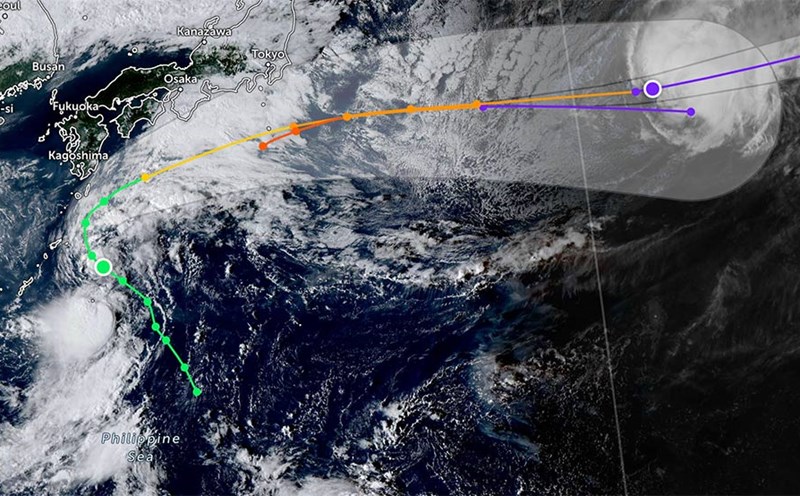
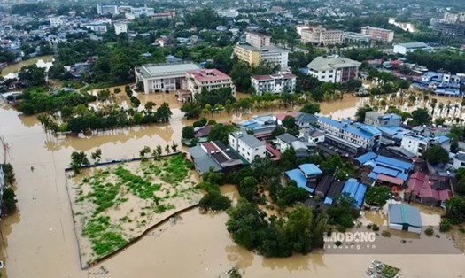
According to the latest storm information from the Philippine Atmospheric, Geophysical and Astronomical Services Administration (PAGASA), at 9:00 a.m. on October 3 (local time), typhoon Matmo (international name: Paolo) made landfall in the Dinapigue area, Isabela province. At the time of landfall, the storm had maximum sustained winds of 130 km/h, gusting up to 180 km/h.
After making landfall, Matmo is forecast to move across much of the Cagayan Valley, Cordillera Administrative Region and Ilocos Region during the day, before heading out to the South China Sea tonight, October 3, becoming the 11th storm.
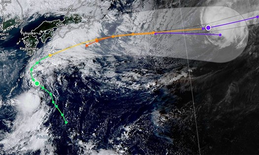
According to the National Center for Hydro-Meteorological Forecasting, by 7:00 a.m. on October 4, storm Matmo will move in a West-Northwest direction at a speed of about 25km/h, entering the East Sea and is likely to strengthen.
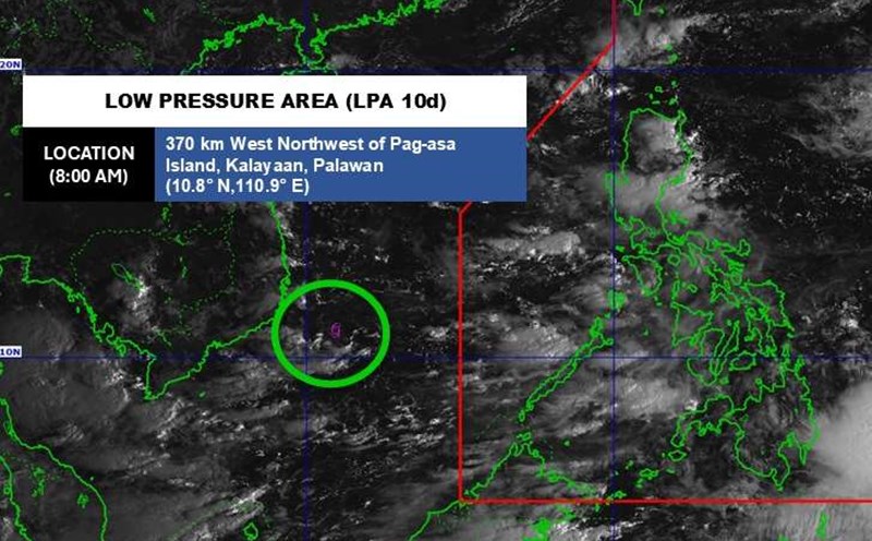
The center of the storm was at about 18.0 degrees North latitude - 116.8 degrees East longitude, in the northern sea of the East Sea, about 750km southeast of the Lusian Peninsula (China).
Strong wind level 10-11, gust level 14. Natural disaster risk level: level 3 for the eastern sea area of the North East Sea.
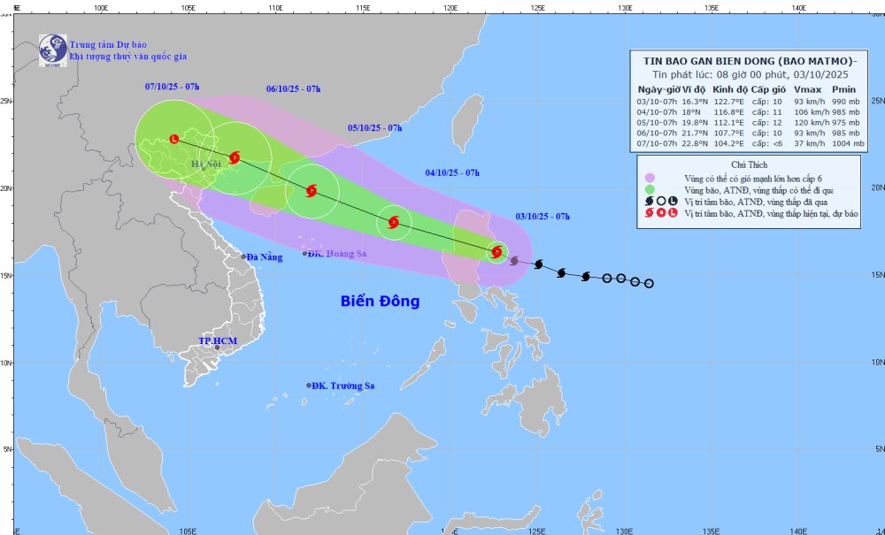
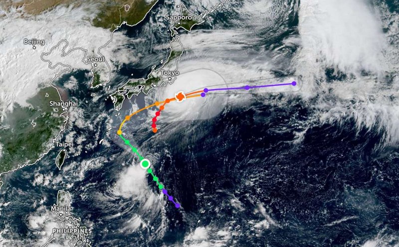
At 7:00 a.m. on October 5, the storm will continue to move in the West Northwest direction at a speed of 20-25km/h and is likely to strengthen. The center of the storm is located at about 19.8 degrees North latitude - 112.1 degrees East longitude, about 200km southeast of the Loi Chau peninsula. Strong storm intensity level 12, gust level 15. Natural disaster risk level: level 3 for the northern sea area of the East Sea.
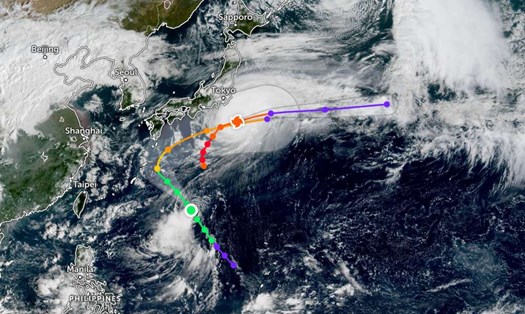
It is forecasted that at 7:00 a.m. on October 6, the storm will enter the Northern Gulf of Tonkin and gradually weaken. The center of the storm is located at about 21.7 degrees North latitude - 107.7 degrees East longitude, in the Northeast region of the North. Strong wind intensity level 10, gust level 13. Natural disaster risk level: level 3, affecting the northwestern sea of the East Sea and the northern area of the Gulf of Tonkin.
In the next 72-96 hours, the storm will continue to move in the West Northwest direction, traveling 15-20km per hour and continuing to weaken.
Due to the influence of storm Matmo, from noon and afternoon of October 3, the eastern sea area of the North East Sea will have winds gradually increasing to level 6-7, then increasing to level 8-9, near the storm center will have strong winds of level 10-11, gusting to level 13. Waves are 4-6m high, the sea is rough.
On October 4-5, the northern sea area of the East Sea is likely to be affected by strong winds of level 11-12, gusting to level 15. Ship operating in dangerous waters are at high risk of thunderstorms, whirlwinds, strong winds and large waves.
People and tourists planning to visit the Philippines or areas where the storm passes should pay attention to weather forecasts. Check flight schedules and follow local instructions to avoid impactful storms.