According to the National Center for Hydro-Meteorological Forecasting, on June 8, cold air affected some places in the northern mountainous region, causing showers and thunderstorms, with locally heavy rain. Temperatures in these areas decreased by about 7-10 degrees Celsius compared to previous days.
Forecast from the evening and night of June 8, cold air will continue to affect other places in the Northeast region, then expand to some places in the Northwest and North Central regions.
On land, the wind turns northeast level 2-3, coastal areas level 3. Due to the impact of cold air, the Northeast region and Thanh Hoa turn cool. The lowest temperature in this cold air wave is commonly from 22-25 degrees C, especially in the Northern mountainous region, some places below 21 degrees C.
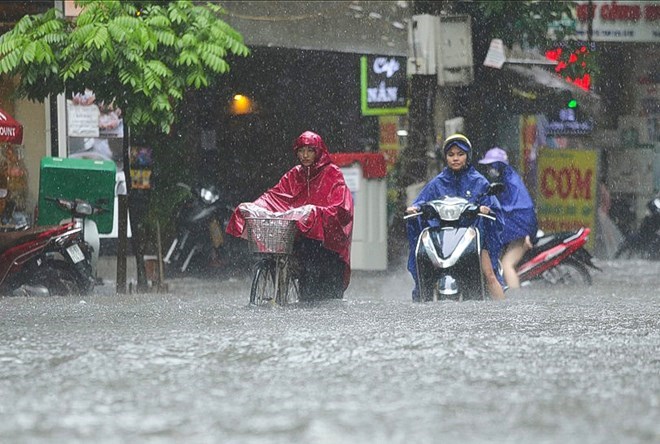
In Hanoi, from the evening of June 8 to the morning of June 9, it is forecast to have moderate rain, heavy rain and thunderstorms, with locally very heavy rain. From the night of June 8, the weather will turn cool, the lowest temperature is commonly from 23-25 degrees C.
The meteorological agency warns that from the evening of June 8 to the night of June 9, the Northwest region, the north of Phu Tho province and Tuyen Quang province will have heavy to very heavy rain with thunderstorms. North Central region will experience moderate to heavy rain, with very heavy rain in some places.
Meanwhile, from the evening of June 8 to the morning of June 9, the remaining areas in the North also had moderate rain, heavy rain and thunderstorms, locally very heavy rain appeared.
Due to the impact of widespread thunderstorms, there is a risk of extreme weather phenomena such as tornadoes, lightning, hail and strong gusts of wind. Prolonged heavy rain can cause flash floods on small rivers and streams, landslides in hilly areas and localized flooding in low-lying areas and urban areas.
At sea, from the night of June 8, the area of the Northern Gulf of Tonkin will have strong northeast winds of level 4-5, sometimes level 6, gusting to level 7. Sea waves are 1.5-2.5m high, rough seas. Dangerous weather conditions may affect the operation of ships and maritime activities in the area.
Meteorological experts recommend that people and tourists continue to closely monitor the developments of the cold air and widespread thunderstorms. Tourists planning to visit the Northern mountainous areas should pay attention to the risk of flash floods and landslides. Should bring umbrellas and raincoats when going out to prevent sudden weather changes.


