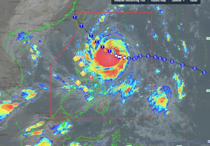
As of 5:00 a.m. on October 29, the center of storm Kong-rey was located at approximately 17.3 degrees North latitude - 127.8 degrees East longitude, 645 km east of Tuguegarao City, Cagayan.
The storm is moving west-northwest at a speed of about 10 km/h. The strongest winds remain at 110 km/h near the storm's center, with gusts reaching up to 135 km/h.

It is forecasted that on October 29, the storm will mainly move in a West-Northwest direction, then turn Northwest on October 31. In the afternoon or evening of October 31, the storm will make landfall on the east coast of Taiwan (China).
The storm then turned north/northeast, moving into the East China Sea and exiting the Philippine forecast area (PAR) on the evening of October 31.
PAGASA said the tropical storm is expected to rapidly intensify as it moves through the Philippine Sea and could reach typhoon strength within the next 12 hours. The possibility of Kong-rey becoming a super typhoon cannot be ruled out.
The Taiwan Weather Administration (CWA) forecasts that Typhoon Kong-rey could become a typhoon on October 29. The storm is expected to make landfall in the island's Taitung County from the night of October 31 to the morning of November 1.
As it strengthens into a typhoon, the storm's radius will expand from 220km at 2pm on October 28 to 250km on the morning of October 29. CWA typhoon forecaster Huang En-hunguy predicted that the storm's size is expected to continue expanding to 280km in the next 24 hours.
Typhoon Kong-rey will have the greatest impact on Taiwan (China) on October 31 and November 1. Heavy to very heavy rain is forecast in the northern, eastern and southern parts of the island and mountainous areas in the central part of the island.


