According to the updated information on the evening of September 7 from the National Center for Hydro-Meteorological Forecasting, storm No. 3 is seriously affecting the northern region of Vietnam.
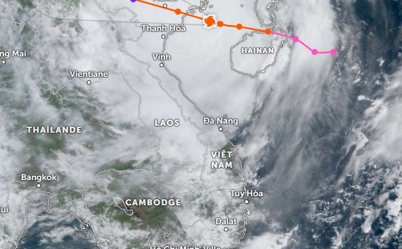
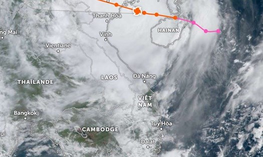
At 9:00 p.m. (September 7), the center of storm No. 3 Yagi was on the mainland of Hanoi Capital, the center of the storm was at about 21.0 degrees North latitude; 105.6 degrees East longitude with the strongest wind level 9-10 (75-102km/h), gusting to level 12.
Meteorologists predict that the storm will continue to cause gusts of wind in the next few hours. It is forecast that in the next 3 hours, the storm will move in a southwest direction, at a speed of about 15-20km/h, towards Hoa Binh province. The storm is likely to weaken into a low pressure area.
Due to the influence of storm No. 3's circulation, Bach Long Vi Island has strong winds of level 13, gusting to level 14; Co To Island has strong winds of level 13, gusting to level 16; Tien Yen (Quang Ninh) has strong winds of level 9, gusting to level 11; Dam Ha (Quang Ninh) has strong winds of level 10, gusting to level 13; Cua Ong (Quang Ninh) has strong winds of level 12, gusting to level 14; Phu Lien (Hai Phong) has strong winds of level 11, gusting to level 14.
Cat Hai (Hai Phong) strong wind level 11, gust level 14; Dong Xuyen (Hai Phong) strong wind level 10, gust level 12; Ba Lat (Thai Binh) strong wind level 9, gust level 12; Van Ly (Nam Dinh) strong wind level 7, gust level 8; Hai Duong strong wind level 12, gust level 13; Luc Ngan (Bac Giang) strong wind level 9, gust level 11; Hung Yen strong wind level 8, gust level 11; Bac Giang strong wind level 7, gust level 9; Bac Ninh strong wind level 7, gust level 10;…
The Northeastern region has suffered heavy to very heavy rain, with rainfall from 0:00 to 19:00 on September 7 in some places exceeding 200mm. Cat Ba (Hai Phong) recorded 215mm, Dong Trieu (Quang Ninh) 224mm, Cam Pha (Quang Ninh) 213mm, Mau Son (Lang Son) 220mm, Phu Duc (Thai Binh) 409mm, Xuan Thuy (Nam Dinh) 221mm.
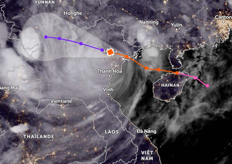
It is forecasted that in the next 12 to 24 hours, storm No. 3 will continue to move in the West-Northwest direction at a speed of 15-20 km/h. According to the graphic predicting the storm's path and current speed, around 11pm - 0am tonight, the storm's center will leave Hanoi.
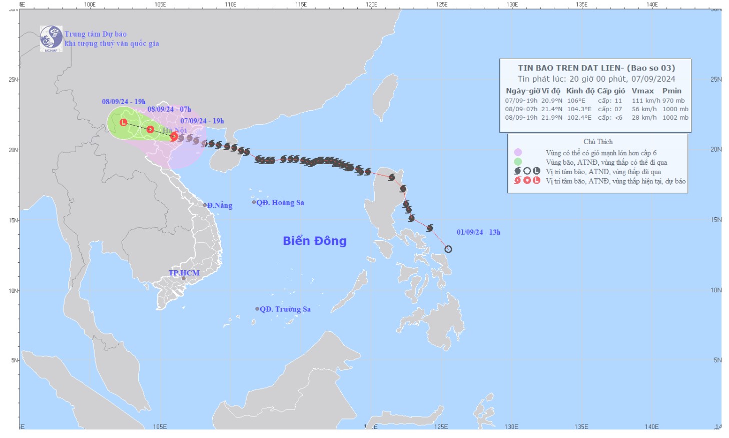
At 7:00 a.m. on September 8, the storm is expected to be located at approximately 21.4 degrees North latitude and 104.3 degrees East longitude in the Northwest region, with a level 6-7 intensity and gusts of level 9-10. The dangerous area will be north of latitude 19.0 degrees North and west of longitude 108.5 degrees East.
By 7:00 p.m. on September 8, the storm will continue to move inland and gradually weaken, forecast to be located at about 21.9 degrees North latitude and 102.4 degrees East longitude, in the Upper Laos region, with an intensity below level 6.
Regarding the impact of the storm, at sea, the Gulf of Tonkin area, including Bach Long Vi and Co To island districts, will continue to experience strong winds of level 8-10, gusting to level 13, and very rough seas.
On land, coastal areas from Quang Ninh to Thanh Hoa will have strong winds of level 7-8, areas near the storm's eye will have strong winds of level 9-11, gusting to level 14, while areas deep inland in the Northeast will have strong winds of level 6-8, gusting to level 9-11.
Waves in the Gulf of Tonkin could be 3.0-5.0m high, while waves in coastal areas from Quang Ninh to Ninh Binh could be 2.0-4.0m high. Boat mooring areas, aquaculture areas, and sea dykes and embankments in the danger zone are all likely to be affected by strong winds, large waves, and storm surges/ebb.
Heavy rain will continue to cause flooding in low-lying areas. From the evening of September 7 to the morning of September 8, the Northeast and Thanh Hoa may record rainfall of 80-180mm, locally over 350mm.
In the afternoon and night of September 8, the rain may decrease slightly but still remain with common rainfall from 20-50mm, some places over 100mm. Particularly in mountainous areas, there will be heavy to very heavy rain with common rainfall from 60-120mm, some places over 250mm.

In the Northwest, from the evening of September 7 to the morning of September 9, rainfall will range from 100-350mm, with some places receiving over 500mm. Heavy rain is likely to cause flash floods on small rivers and streams and landslides on steep slopes.
Faced with the complicated storm situation, residents and tourists in the affected areas are advised to stay indoors, reinforce their houses from the inside and stay calm until the storm passes.