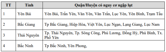
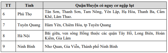
15/25 Northern provinces face risk of flash floods and landslides
According to data from the National Center for Hydro-Meteorological Forecasting, in the past 24 hours (from 2:00 p.m. on September 9 to 2:00 p.m. on September 10), the Northern provinces and Thanh Hoa had moderate rain, heavy rain, and very heavy rain in some places such as: Nam Cuoi 79.2mm (Lai Chau); Dong Tam 296.8mm (Hoa Binh); Cam Duong 208.6mm (Lao Cai); Minh Bao 401.2mm (Yen Bai); Nam Dan 164mm (Ha Giang); Hung Duc 121mm (Tuyen Quang); Dai Pham 209mm (Phu Tho); Hoang Nong 120mm (Thai Nguyen); Dam Ha 238mm (Quang Ninh); Cam Luong 120mm (Thanh Hoa)...
Soil moisture models show that some areas in the above provinces are close to saturation (over 85%) or have reached saturation.
The Meteorological Agency forecasts that in the next 3-6 hours, the Northeast region and Thanh Hoa will have rain with average rainfall of 30-60mm, some places over 100mm; other areas in the North will have rain with rainfall of 10-30mm, some places over 50mm.
In the next 6 hours, there is a risk of flash floods on small rivers and streams, landslides on steep slopes in many districts, specifically as follows:

Flood warning on many rivers in the North
In the past hours, floods on Thao River in Lao Cai City and Yen Bai have been above historical flood levels.
It is forecasted that in the next 12 hours , the flood on Thao River in Lao Cai will continue to decrease; in Yen Bai it will decrease slowly but still above the historical flood level; in Phu Tho it will rise to alert level 2.
Floods on the Lo River in Tuyen Quang are likely to peak at 27.3m, 1.3m above alert level 3 tonight (September 10); in Vu Quang, they will continue to rise and peak at 20.4m, about 0.1m below alert level 3, tonight (September 10).
Floods on the Cau River continue to rise and are above alert level 3; the Thuong River continues to rise slowly above alert level 3.
Floods on Luc Nam River are slowly receding below alert level 3.
Floods on the Thai Binh River continue to rise above alert level 2.
Floods on the Hoang Long River continue to rise above alert level 3.
Floods on the Red River in Hanoi continue to rise rapidly below alert level 2.
In the next 12-24 hours , the flood on Thao River in Lao Cai will continue to recede; in Bao Ha it will recede slowly; in Yen Bai it will continue to recede but still above historical flood levels; in Phu Tho it will rise above alert level 2.
The flood on the Lo River will recede slowly.
Floods on Thuong and Cau rivers are changing slowly and remain at alert level 3.
Luc Nam River flood continues to fall below alert level 3.
Floods on the Thai Binh River continue to rise to alert level 3.
Floods on the Hoang Long River will change slowly above alert level 3.
Floods on the Red River in Hanoi will rise slowly and stay below alert level 2.
In the next 12 to 24 hours, the water level at downstream stations of the Red River - Thai Binh River system is likely to rise to alert level 3 and above alert level 3. Rising flood water levels cause flooding in low-lying areas along the river, alluvial areas outside the main dike, causing riverbank alluvial overflows, dyke erosion, seriously affecting vulnerable locations in the dyke system, embankments, and riverside works in the provinces: Hanoi, Ha Nam, Nam Dinh, Hai Duong, Hung Yen, Thai Binh, Ninh Binh.
There is a high risk of flooding in low-lying areas along rivers in the provinces of Lang Son, Cao Bang, Lao Cai, Yen Bai, Phu Tho, Bac Giang, Bac Kan, Thai Nguyen, Hoa Binh; flash floods and landslides on steep slopes in the mountainous areas of the North. The flood risk warning level is level 3.