
Today (August 23), the Northeast region and Thanh Hoa have moderate rain, heavy rain and thunderstorms, with locally very heavy rain. The cause of the rain is due to the impact of storm No. 4.
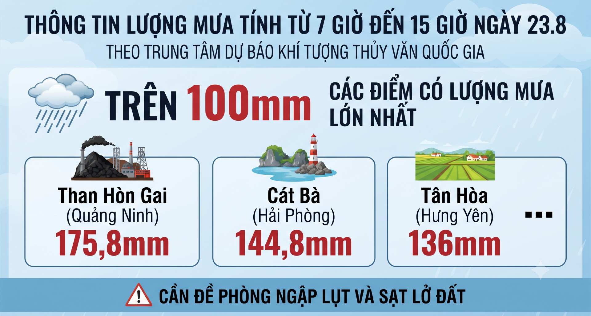
Rain tends to gradually decrease from the night of August 24.
The Northeast region, the south of Phu Tho and Thanh Hoa provinces from the evening of August 23 to the end of August 24, will have moderate rain, heavy rain and thunderstorms with common rainfall from 30 - 70mm, locally very heavy rain over 150mm.
Especially the areas of Bac Ninh, Quang Ninh, Hai Phong, Hung Yen, Ninh Binh, Thanh Hoa have heavy to very heavy rain with common rainfall of 60 - 120mm, locally over 250mm. Warning of the risk of heavy rain with rainfall greater than 120mm/3h.
From the night of August 24, heavy rain in the Northeast region, the south of Phu Tho and Thanh Hoa provinces tends to gradually decrease.
The Northwest region, Nghe An from the evening of August 23 to August 24, will have scattered showers and thunderstorms with rainfall of 15-30mm, locally heavy rain over 80mm.
In thunderstorms, there is a possibility of tornadoes, lightning and strong gusts of wind. Warning level of natural disaster risk due to heavy rain, tornadoes, lightning, and hail is level 1, especially Quang Ninh, Hai Phong, and Bac Ninh areas level 2.
Flood warnings downstream of Luc Nam and Thuong rivers
Lowwater floods on the Luc Nam and Thuong rivers (Bac Ninh) are trending upwards. Water level at 1:00 PM on August 23rd on the Luc Nam River at Luc Nam station is 6.63m, 0.33m above alarm level 3; on the Thuong River at Phu Lang Thuong station is 5.8m, about 0.5m above alarm level 2.
Forecast for the next 6-12 hours, floods downstream of the Luc Nam and Thuong rivers will continue to rise and be above alarm level 3.
In the next 12-24 hours, floods downstream of the Luc Nam and Thuong rivers will fluctuate above alarm level 3.
From now (August 23) to August 25, floods on rivers in the Northeast region are likely to remain at high levels, peak floods on the Cau River, Thuong River, Luc Nam River; Trung, Ky Cung, Bac Giang (Lang Son) rivers at alarm level 2-alerte level 3, some rivers above alarm level 3; Bang Giang River (Cao Bang), Thai Binh River (Hai Phong) at Pha Lai station rise to alarm level 1-alerte level 2.
Warning of flooding in low-lying, riverside areas of communes/wards in Bac Ninh province such as Tuan Dao, An Lac, Duong Huu, Tay Yen Tu, Dai Son, Bien Son, Bien Dong, Yen Dinh, Phuong Son, Chu, Nam Duong, Luc Ngan, Deo Gia, Truong Son, Luc Son, Luc Nam, Nghia Phuong, Cam Ly, Bac Lung, Sa Ly, Hop Thinh, Xuan Cam, Yen Trung, Nenh, Yen Dung, Canh Thuy, Kep, Tien Luc, Nha Nam, Yen The, Tien Phong, Tan An, Lang Giang, Bo Ha, My Thai, Dong Ky, Xuan Luong.
High risk of flash floods on small rivers and streams and landslides on slopes in Quang Ninh, Lang Son, Bac Ninh, Cao Bang, and Thai Nguyen provinces.
Warning level of natural disaster risk due to floods is level 3. River floods cause flooding in low-lying areas along rivers, affecting activities such as waterway traffic, aquaculture, agricultural production, people's livelihoods and socio-economic activities.


