
Currently, storm No. 4 is operating in the sea area of Quang Ninh-Hai Phong and has complicated developments. The strongest wind in the area near the storm center is strong at level 8, gusting at level 10.
Storm No. 4 goes around for many days

Mr. Hoang Phuc Lam - Deputy Director of the National Center for Hydro-Meteorological Forecasting has made noteworthy analyses related to the windy path of this storm.
According to Mr. Lam, in the next 72 hours, storm No. 4 will move slowly at an average speed of about 3-5km/h and continuously change direction, going around the Gulf of Tonkin for many days.
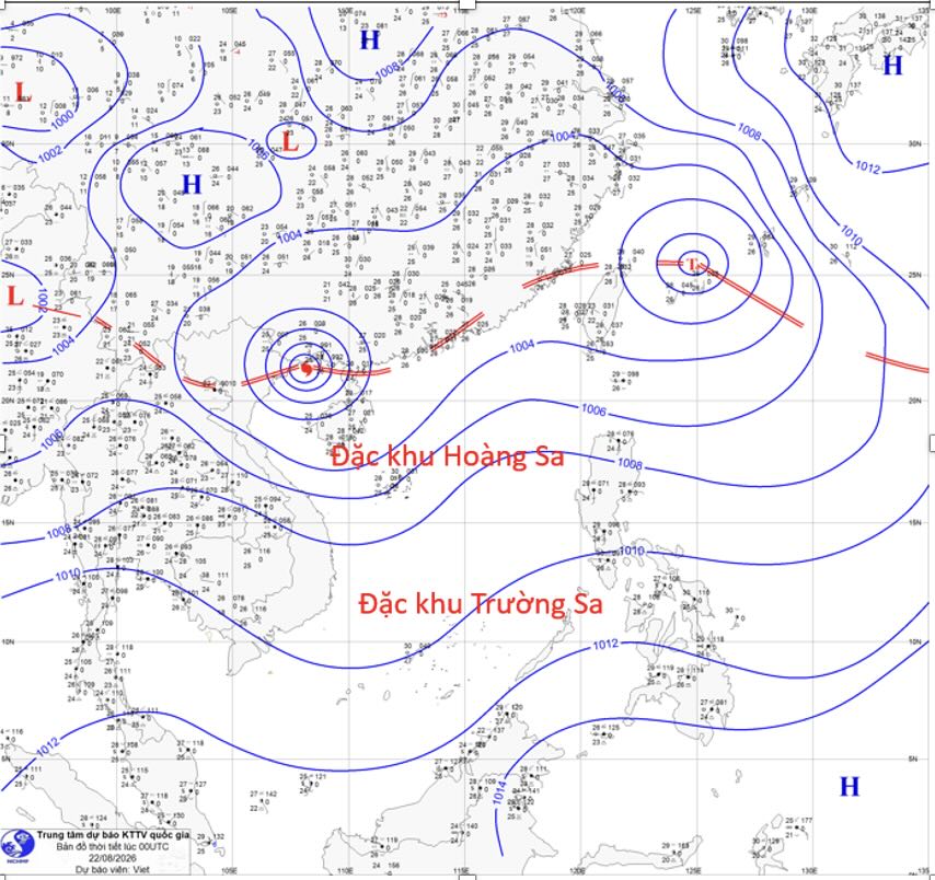
The reason is that storm No. 4 is currently operating on a tropical convergence zone with its axis passing through the Northern region and the sea area north of the Gulf of Tonkin, weakly affected by environmental factors dominating the storm's movement (aerial guidance, vertical wind interruption...). In the next 24 hours, storm No. 4 will move in a South-Southwest direction, then change direction to Southeast in the 24-48 hour period and continue to change direction to East-Northeast (outward direction) in the 48-72 hour period" - Mr. Lam analyzed.
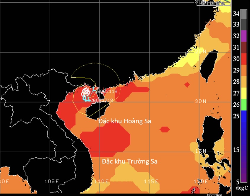
Representatives of the meteorological agency added that the sea surface temperature in the Gulf of Tonkin, in the area where storm No. 4 is operating, is relatively high. The humidity provided for the storm's activity is still relatively high, and the storm moves slowly, so storm No. 4 is still likely to strengthen, but the strength of the storm is not much.
The main impacts of storm No. 4
Mr. Hoang Phuc Lam assessed that due to the impact of storm No. 4, the Gulf of Tonkin area (including Bach Long Vi, Van Don, Co To, Cat Hai special zones; Hon Dau island), coastal sea areas of Quang Ninh and Hai Phong provinces will be long-term affected by the circulation of storm No. 4 with strong winds of level 6-7, near the storm center level 8, gusts of level 10; sea waves 2-4m high; strong rough seas.
On the mainland coast of Quang Ninh province and Hai Phong city, there are strong winds at level 6-7, gusts at level 8-9. Strong winds can blow off houses, damage temporary structures, break down green trees and billboards; affecting electricity and traffic systems.
In addition, due to the influence of the circulation of storm No. 4 and the tropical convergence zone passing through the Northern region in the Northeast region, the south of Phu Tho and Thanh Hoa provinces from August 22 to the night of August 24, the common rainfall is 100-200mm, locally over 400mm; especially Quang Ninh, Hai Phong commonly 250-350mm, locally over 600mm; Lang Son, Bac Ninh, commonly 200-300mm, locally over 500mm. After the night of August 24, widespread rain is still likely to last in the Northern region and Thanh Hoa" - Mr. Lam recommended.
Heavy rain may cause flooding in urban areas, industrial parks and low-lying areas; increasing the risk of floods on small rivers and streams, flash floods and landslides in mountainous areas.
On the afternoon of August 21, the tropical depression over the Gulf of Tonkin strengthened into a storm, storm No. 4 and has the international name Narra (named after the Philippines. Narra in Filipino is a sandalwood tree and also a national symbol of the Philippines).


